Enable Location

We need your location to show you interesting places around you

Discover nearby places

Find interesting locations and hidden gems around you

Precise directions

Get accurate directions and distances to places

Your location is never shared with other users. It's only used when you tap the location button.

Sears-Kay Ruin

Log in to your account

Start exploring — it's free

Trusted by 66,614 travelers worldwide

Continue with Google
Continue with Apple
or

We will send you a code to connect

By continuing, you accept our Terms and Conditions and our Privacy Policy

Check your inbox

We've sent a pincode in your inbox. Please enter the code below.

Discussion Reviews 1 Photos
4k Popularity

Sears-Kay Ruin, Archaeological site in Carefree, United States.

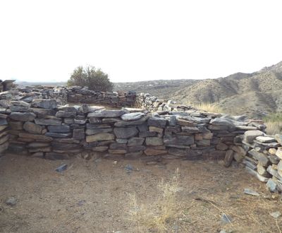
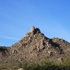
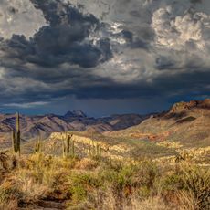
Sears-Kay Ruin is an archaeological site set on a hilltop inside Tonto National Forest in Maricopa County, Arizona. The site holds around 40 stone chambers with walls and foundations still visible, arranged in a pattern that points to a fortified settlement.

The Hohokam people built this settlement around 1050 and lived there for roughly 150 years. They left around 1200, and no one has yet found a clear reason for their departure.

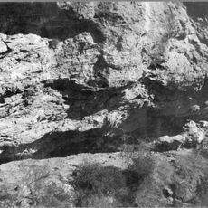
The stone walls visible here show building techniques developed by the Hohokam people, which later shaped how the Akimel O'odham and Tohono O'odham built their own structures. Visitors can walk close to the walls and observe how the stones were fitted together without mortar.

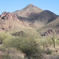
The ruins are reached by a short hiking trail with a moderate elevation change, so sturdy shoes are a good idea. Desert conditions mean the heat can be intense, and carrying enough water is important, especially in summer.

One chamber on the site, known as the Mystery Room, has rounded corners instead of the square angles found in every other room. Researchers have not yet found a convincing explanation for this difference, making it one of the more puzzling details of the site.

The community of curious travelers

AroundUs brings together thousands of curated places, local tips, and hidden gems, enriched daily by 60,000 contributors worldwide.

Start exploring
Location
GPS coordinates
33.84432,-111.28450
Latest update
March 3, 2026 10:05
Around this place
Canyon Lake
United States of America

Canyon Lake

36.3 km
Lost Dutchman State Park
United States of America

Lost Dutchman State Park

46.8 km
Four Peaks
United States of America

Four Peaks

18.2 km
Saguaro Lake
United States of America

Saguaro Lake

37.9 km
Weaver's Needle
United States of America

Weaver's Needle

46.4 km
Pinnacle Peak
United States of America

Pinnacle Peak

55.2 km
Skeleton Cave
United States of America

Skeleton Cave

30.3 km
Salt River Canyon Wilderness
United States of America

Salt River Canyon Wilderness

48.3 km
United States of America

Mount McDowell

50.8 km
Stewart Mountain Dam
United States of America

Stewart Mountain Dam

38.7 km
Mormon Flat Dam
United States of America

Mormon Flat Dam

35.4 km
Roosevelt Lake Bridge
United States of America

Roosevelt Lake Bridge

22.3 km
Thompson Peak
United States of America

Thompson Peak

53.7 km
Verde River Sheep Bridge
United States of America

Verde River Sheep Bridge

46.9 km
United States of America

Peralta Canyon

52.1 km
Pinnacle Peak Park
United States of America

Pinnacle Peak Park

54.9 km
Sierra Ancha Wilderness
United States of America

Sierra Ancha Wilderness

37.7 km
Gold Canyon Golf Resort
United States of America

Gold Canyon Golf Resort

54.8 km
Pleasant Valley Ranger Station
United States of America

Pleasant Valley Ranger Station

43.7 km
Fountain Hills Observatory
United States of America

Fountain Hills Observatory

48.2 km
Las Sendas Golf Club
United States of America

Las Sendas Golf Club

53.8 km
Tonto National Monument Visitor Center
United States of America

Tonto National Monument Visitor Center

27.3 km
Verde River Golf and Social Club
United States of America

Verde River Golf and Social Club

39.8 km
Desert Canyon Golf Course
United States of America

Desert Canyon Golf Course

49.1 km
Boulder Creek Bridge
United States of America

Boulder Creek Bridge

36.9 km
Aztec Peak Lookout
United States of America

Aztec Peak Lookout

35 km
Mormon Flat Bridge
United States of America

Mormon Flat Bridge

37.1 km
Alchesay Canyon Bridge
United States of America

Alchesay Canyon Bridge

22.8 km
Show the full map
Reviews
Share your experience

No review yet

Discussions
Start a discussion...

No discussion yet

« Sears-Kay Ruin - Archaeological site in Carefree, United States » is provided by Around Us (aroundus.com). Images and texts are derived from Wikimedia project under a Creative Commons license. You are allowed to copy, distribute, and modify copies of this page, under the conditions set by the license, as long as this note is clearly visible.

Discover hidden gems everywhere you go!

From secret cafés to breathtaking viewpoints, skip the crowded tourist spots and find places that match your style. Our app makes it easy with voice search, smart filtering, route optimization, and insider tips from travelers worldwide. Download now for the complete mobile experience.

Around Us App Screenshot

A unique approach to discovering new places

Le Figaro

All the places worth exploring

France Info

A tailor-made excursion in just a few clicks

20 Minutes

Around Us
Travel Guide & Maps
Download

Send to your phone

QR Code
1

Open the camera app on your mobile.

2

Point at the QR code with your camera. A notification will appear.

3

Tap the notification to open the link.