Enable Location

We need your location to show you interesting places around you

Discover nearby places

Find interesting locations and hidden gems around you

Precise directions

Get accurate directions and distances to places

Your location is never shared with other users. It's only used when you tap the location button.

Canyon Lake

Log in to your account

Start exploring — it's free

Trusted by 62,465 travelers worldwide

Continue with Google
Continue with Apple
or

We will send you a code to connect

By continuing, you accept our Terms and Conditions and our Privacy Policy

Check your inbox

We've sent a pincode in your inbox. Please enter the code below.

Canyon Lake

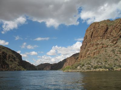
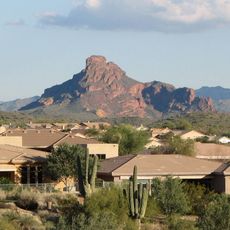
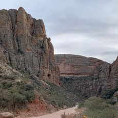
Canyon Lake, Reservoir in Tonto National Forest, Arizona, United States

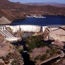
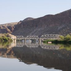
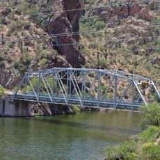
Canyon Lake is a reservoir in Tonto National Forest, Arizona, covering 950 acres and enclosed by steep canyon walls. The body of water stretches through desert terrain with 30 miles (48 km) of shoreline winding along the rocky landscape.

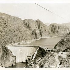
The Mormon Flat Dam was built between 1923 and 1925, forming Canyon Lake as part of the Salt River Project water management system. This construction marked one of the first major dams in the region, enabling agricultural irrigation and power generation for central Arizona.

The Dolly Steamboat continues the century-old tradition of guided water tours, offering dinner cruises through the desert canyons.

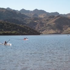
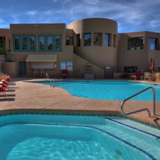
The marina at the site offers equipment rentals for water activities, including pontoon boats, canoes, and fishing gear throughout the year. The area sits about an hour northeast of Phoenix by car, with access to several hiking trails along the shore.

The water holds several fish species including rainbow trout, largemouth bass, and walleye at an elevation of 1660 feet (506 m) above sea level. A historic paddle wheeler vessel regularly cruises across the lake, echoing earlier modes of transport in the region.

The community of curious travelers

AroundUs brings together thousands of curated places, local tips, and hidden gems, enriched daily by 60,000 contributors worldwide.

Start exploring
Location
GPS coordinates
33.54360,-111.43700
Latest update
December 5, 2025 22:29
Around this place
Lost Dutchman State Park
United States of America

Lost Dutchman State Park

10.4 km
Four Peaks
United States of America

Four Peaks

18.8 km
Saguaro Lake
United States of America

Saguaro Lake

8.7 km
Weaver's Needle
United States of America

Weaver's Needle

13.7 km
Skeleton Cave
United States of America

Skeleton Cave

7.6 km
United States of America

Mount McDowell

23.8 km
Arizona Commemorative Air Force Museum
United States of America

Arizona Commemorative Air Force Museum

29.5 km
Buckhorn Baths Motel
United States of America

Buckhorn Baths Motel

28.4 km
Stewart Mountain Dam
United States of America

Stewart Mountain Dam

9.5 km
Mormon Flat Dam
United States of America

Mormon Flat Dam

1.3 km
Roosevelt Lake Bridge
United States of America

Roosevelt Lake Bridge

29.7 km
United States of America

Peralta Canyon

19.5 km
United States of America

Buckhorn Hot Mineral Wells

28.3 km
Gold Canyon Golf Resort
United States of America

Gold Canyon Golf Resort

19.3 km
Fountain Hills Observatory
United States of America

Fountain Hills Observatory

29.9 km
Las Sendas Golf Club
United States of America

Las Sendas Golf Club

22.6 km
Desert Sands Golf Course
United States of America

Desert Sands Golf Course

28.3 km
Sunland Springs Golf
United States of America

Sunland Springs Golf

24.1 km
Stapley Aquatic Center
United States of America

Stapley Aquatic Center

31.3 km
Desert Canyon Golf Course
United States of America

Desert Canyon Golf Course

26.1 km
Falcon Field Airport
United States of America

Falcon Field Airport

28.6 km
Goldfield Ghost Town
United States of America

Goldfield Ghost Town

10.7 km
Shepherd Aquatic Complex
United States of America

Shepherd Aquatic Complex

27.4 km
Apache Trail
United States of America

Apache Trail

17.1 km
Boulder Creek Bridge
United States of America

Boulder Creek Bridge

1.7 km
Mormon Flat Bridge
United States of America

Mormon Flat Bridge

793 m
Alchesay Canyon Bridge
United States of America

Alchesay Canyon Bridge

29.2 km
Queen Creek Bridge
United States of America

Queen Creek Bridge

30.2 km
Show the full map
« Canyon Lake - Reservoir in Tonto National Forest, Arizona, United States » is provided by Around Us (aroundus.com). Images and texts are derived from Wikimedia project under a Creative Commons license. You are allowed to copy, distribute, and modify copies of this page, under the conditions set by the license, as long as this note is clearly visible.

Discover hidden gems everywhere you go!

From secret cafés to breathtaking viewpoints, skip the crowded tourist spots and find places that match your style. Our app makes it easy with voice search, smart filtering, route optimization, and insider tips from travelers worldwide. Download now for the complete mobile experience.

Around Us App Screenshot

A unique approach to discovering new places

Le Figaro

All the places worth exploring

France Info

A tailor-made excursion in just a few clicks

20 Minutes

Around Us
Travel Guide & Maps
Download

Send to your phone

QR Code
1

Open the camera app on your mobile.

2

Point at the QR code with your camera. A notification will appear.

3

Tap the notification to open the link.