See the monuments around you in AROpen chests in the app
Around Us is built for your phone — point your camera at the streets and discover the monuments and places around you in augmented reality.Around Us is built for your phone — chests unlock when you walk, explore and capture nearby places.
Arizona contains geological formations spanning millions of years alongside evidence of Spanish colonial settlement and prehistoric cultures. The landscape includes sandstone canyons such as Antelope Canyon X and Canyon de Chelly National Monument, extensive desert areas with saguaro and organ pipe cacti, and volcanic remnants at Sunset Crater. Historical sites include Spanish missions like Tumacácori, pueblo ruins at Montezuma Castle, and mining towns such as Bisbee and Jerome.
The state holds significant paleontological sites at Petrified Forest National Park, where fossilized tree trunks from the Triassic period lie exposed, and cave systems like Kartchner Caverns with active speleothem formations. The Vermilion Cliffs region displays layered sandstone formations including The Wave, while the Chiricahua Mountains show volcanic rock pinnacles formed from welded ash. Waterfalls such as Havasu Falls and Grand Falls result from geological faulting and seasonal water flow.
Archaeological sites document occupation by the Hohokam, Sinagua, and Ancestral Puebloans between 300 and 1400 CE. Tonto Natural Bridge forms one of the largest travertine bridges in North America, while Besh-Ba-Gowah shows Salado culture construction methods from the 13th century. The territory spans from the Sonoran Desert in the south to the Colorado Plateau in the north, creating distinct climate zones and ecosystems within a compact area.
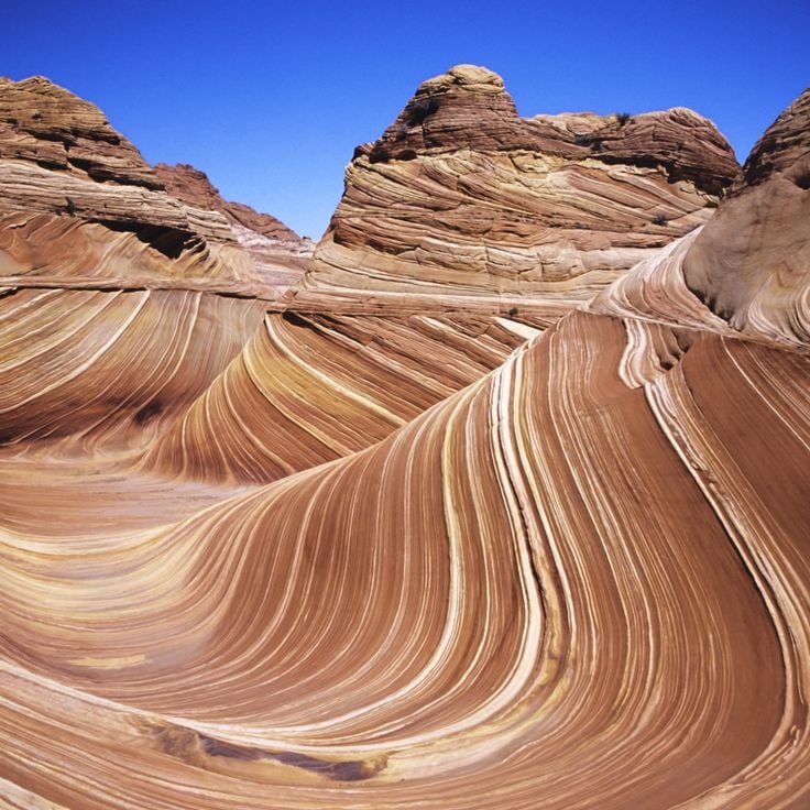
This sandstone formation developed through natural erosion processes over millions of years. The undulating structures display horizontally bedded layers of consolidated sand from the Navajo Formation, deposited during the Jurassic period approximately 190 million years ago. The formations sit in the northern part of Arizona near the Utah border and represent geological features of the American Southwest. Access to this area is limited to 64 people per day, and visitors require a permit obtained through a lottery system. The hike to the formation covers roughly 6 miles (10 kilometers) of unmarked terrain without established trails.
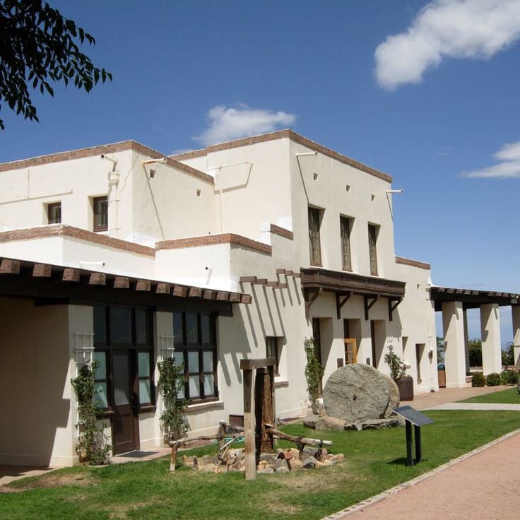
This park displays Spanish colonial architecture with mission buildings from the 18th century. The site documents Native American history in Arizona and preserves three mission ruins from the Spanish colonial period. Tumacácori National Historical Park lies in the Santa Cruz River Valley and provides insight into the cultural connections between Spanish missionaries and the Tohono O'odham and Yaqui peoples. The adobe structures show the architectural methods of the colonial period with vaulted ceilings, wall paintings, and an open church nave.
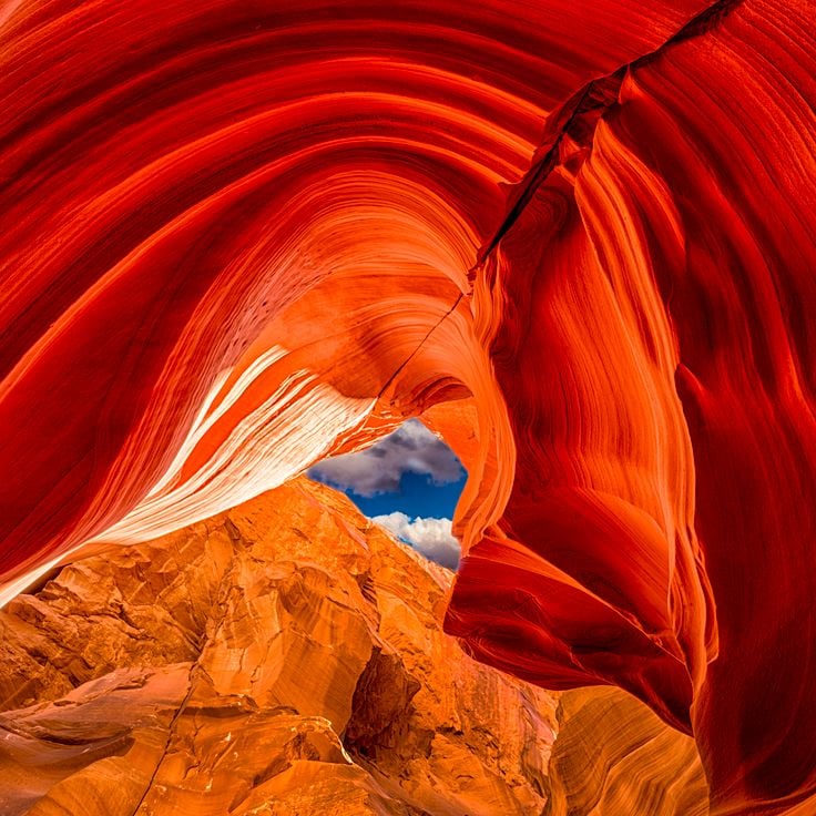
This canyon section lies within the Navajo Nation and displays sandstone formations shaped by water erosion over thousands of years. Daylight enters through narrow openings and creates changing light effects on the undulating rock walls. The geological structures belong to the Navajo Sandstone, deposited approximately 190 million years ago during the Jurassic period. The canyon extends several hundred yards and the passageways measure less than 3 feet (about 1 meter) wide in places. Visitor numbers are lower than in other sections of the Antelope Canyon formation, allowing longer stays in individual areas. These slot canyons formed through periodic flash floods that carved away the soft sandstone rock.
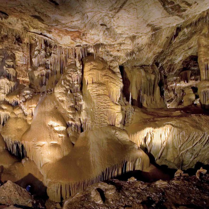
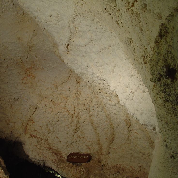
This cave system in Arizona displays underground formations including stalactites, stalagmites and mineral deposits. The system remained hidden until 1974 and maintains a constant temperature of 68 degrees Fahrenheit (20 degrees Celsius) throughout the year. The caverns preserve active formations that continue to grow, including columns and shield formations. Kartchner Caverns State Park provides access to these geological features through guided tours that explain the development of the cave system over thousands of years. This site contributes to the collection of historical and natural areas in Arizona, presenting the underground geology of the region.
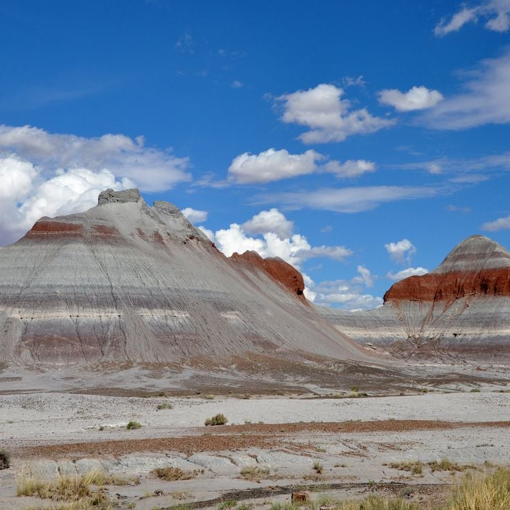
Petrified Forest National Park preserves a landscape of fossilized tree trunks dating from the Triassic period approximately 225 million years ago. This collection of geological formations, desert landscapes and historical sites in Arizona presents the fossilized remains of an ancient forest transformed into quartz. The park contains colorful rock formations of the Chinle Formation along with petroglyphs created by Ancestral Puebloans and other indigenous peoples who carved into the rock hundreds of years ago. The park badlands display layers of colored claystone and sandstone spanning several hundred feet (91 to 152 m).
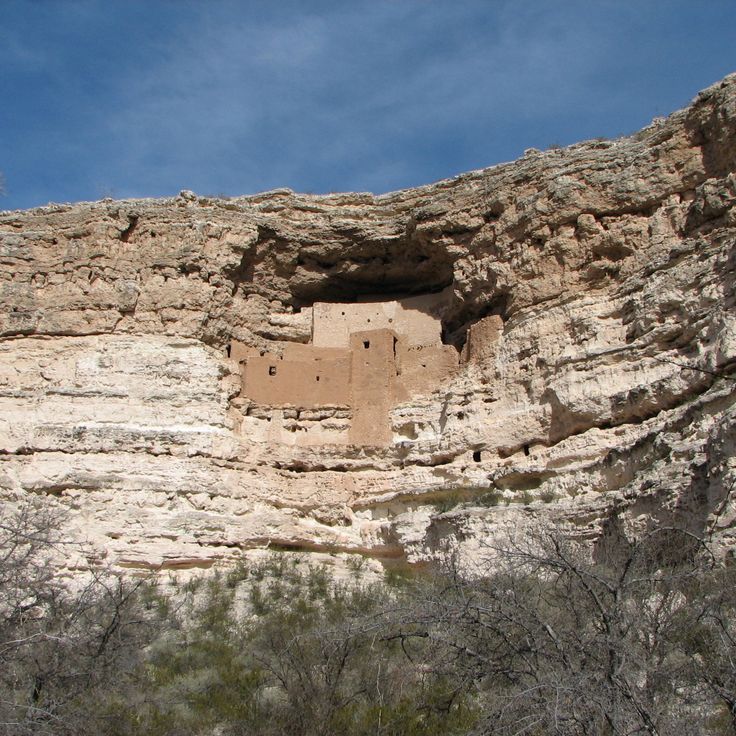
Montezuma Castle National Monument preserves a five-story residential complex from the 12th century built into a natural limestone cave 100 feet (30 meters) above the valley floor. This structure demonstrates the construction methods of the Sinagua people in the Arizona uplands. The archaeological site documents adaptation to the regional topography and represents evidence of pre-Columbian settlement in the American Southwest. Located along Beaver Creek, this complex illustrates the relationship between geological formations and historical land use in Arizona.
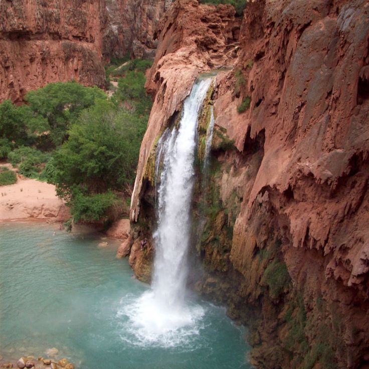
This waterfall in the Havasupai Reservation drops approximately 100 feet into turquoise pools. The water gains its distinctive color from high calcium carbonate content dissolved in the rock. Havasu Falls is one of several waterfalls in Havasu Creek Canyon, which flows through the Supai Formation of the Colorado Plateau. Access requires a hike of approximately 10 miles from the trailhead or helicopter transportation. The area is located on Havasupai tribal land and requires advance permits for visitation.
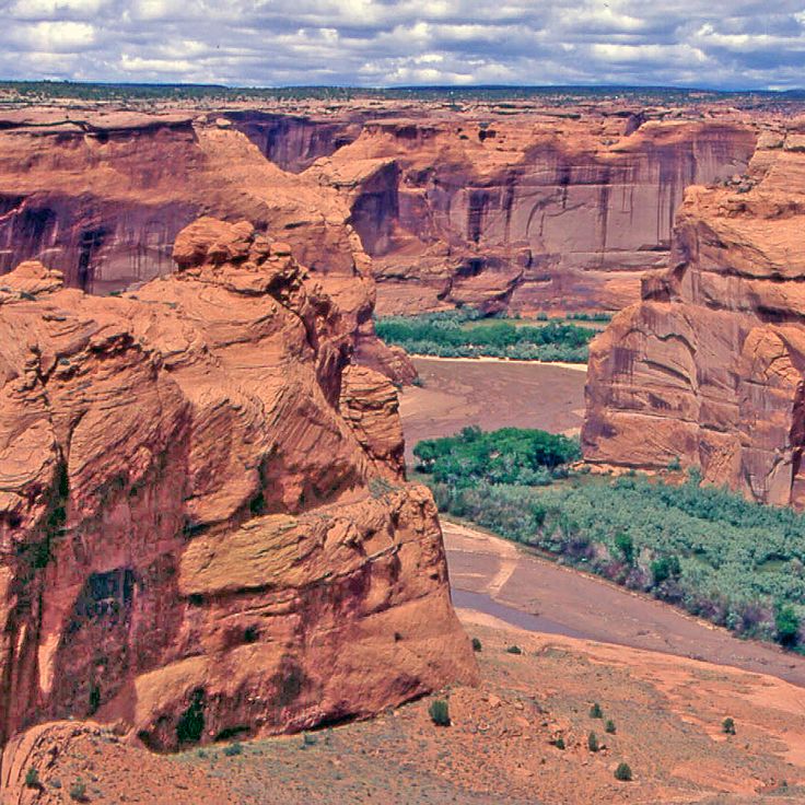
This national monument preserves Anasazi cliff dwellings from the 4th century and agricultural lands used by the Navajo people. The walls of Canyon de Chelly rise up to 1,000 feet (305 meters) from the valley floor and display geological layers of red sandstone. The archaeological sites include White House Ruins and Antelope House, built within alcoves in the rock faces. Several side canyons such as Canyon del Muerto contain additional ruins and rock art. The canyon lies within the Navajo Nation and demonstrates the continuous habitation and use of the area by different cultures over more than 1,500 years.
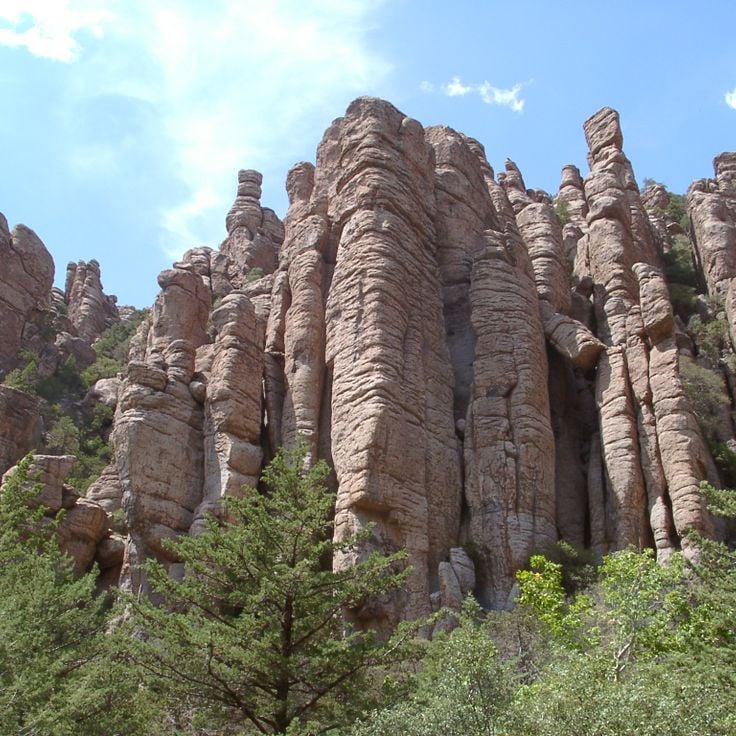
The Chiricahua National Monument preserves volcanic formations that originated about 27 million years ago. The vertical rock columns, natural stone arches, and balanced boulders formed through erosion of rhyolitic tuff from a caldera eruption. This monument encompasses more than 18 square miles (47 square kilometers) of the Chiricahua Mountains in southeastern Arizona. The rock formations reach heights of up to 200 feet (60 meters), and the area demonstrates geological processes shaped by water, wind, and temperature changes.
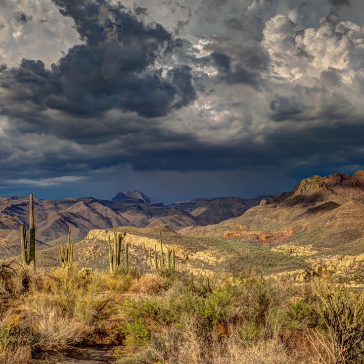
This Sonoran Desert preserve covers 517 square miles (1,338 square kilometers) of arid terrain displaying various species of cacti, including the namesake organ pipe cacti with their multiple vertical stems rising in arms. The landscape of Organ Pipe Cactus National Monument encompasses two mountain ranges, flat bajadas, and desert valleys where senita cacti, saguaros, and over 30 other cactus species grow. The area sits along the Arizona-Sonora border and features geological formations of volcanic rock and sedimentary layers formed over 18 million years.
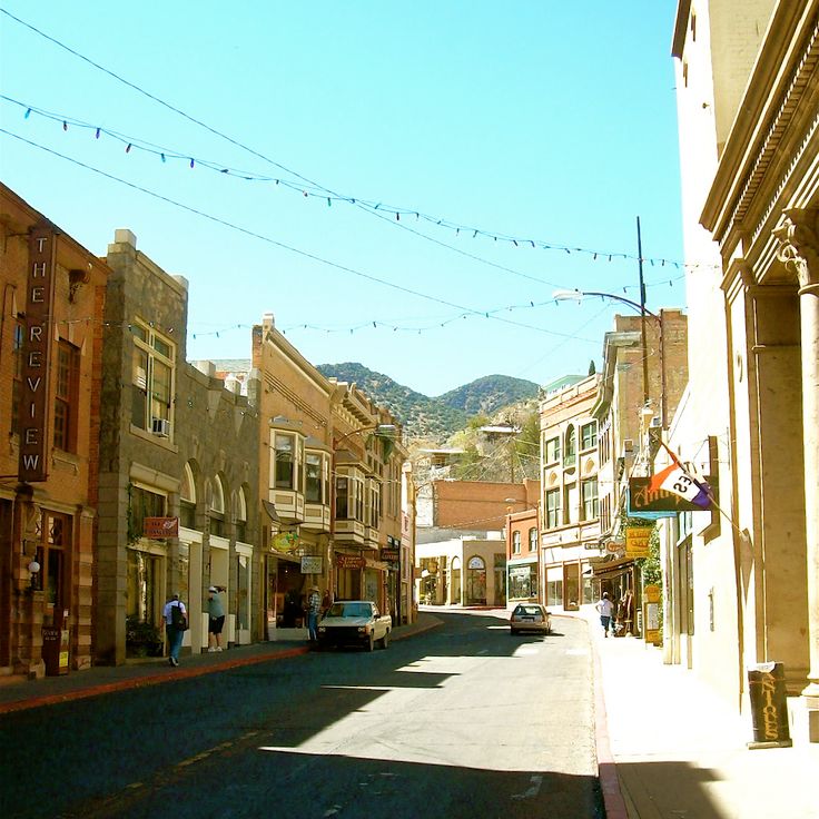
This former copper mining town in the Mule Mountains consists of Victorian buildings clinging to steep hillsides. Bisbee was established in the late 19th century during the mining boom and became one of the world's most productive copper mining operations. The historic downtown preserves hundreds of buildings from this era, including the Copper Queen Hotel and the Phelps Dodge General Office Building. After the mines closed in the 1970s, artists and craftspeople transformed the town into a cultural community. Museums document the mining history and offer tours through underground mine shafts.
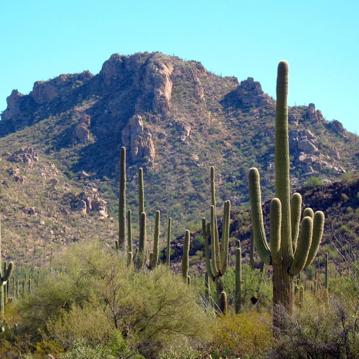
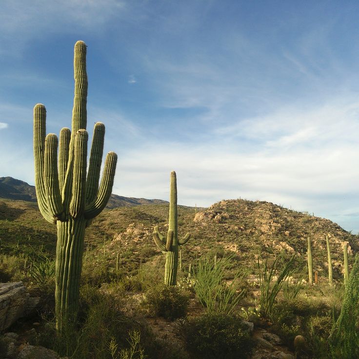
Saguaro National Park protects large stands of Saguaro cacti, which grow up to 50 feet (15 meters) tall in the Sonoran Desert environment. This protected area preserves the characteristic vegetation of the region and displays the geological formations of the American Southwest. The park occupies two separate districts east and west of Tucson, providing access to desert landscapes with numerous cactus species and varied plant and animal communities adapted to the extreme conditions of the Sonoran Desert climate.
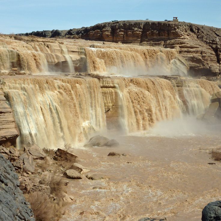
These falls in Navajo territory drop 185 feet over volcanic rock into a narrow gorge. Grand Falls flows primarily during spring snowmelt and after rainstorms, when the Little Colorado River carries large amounts of reddish sediment. The cascades formed approximately 100,000 years ago when lava flows from nearby Merriam Crater blocked the original river channel, forcing the water to carve a new course over the basalt cliffs. The area lies within the Painted Desert and is part of the Navajo Nation. The falls frequently run dry during summer months, leaving only the exposed volcanic rock formations of layered basalt.
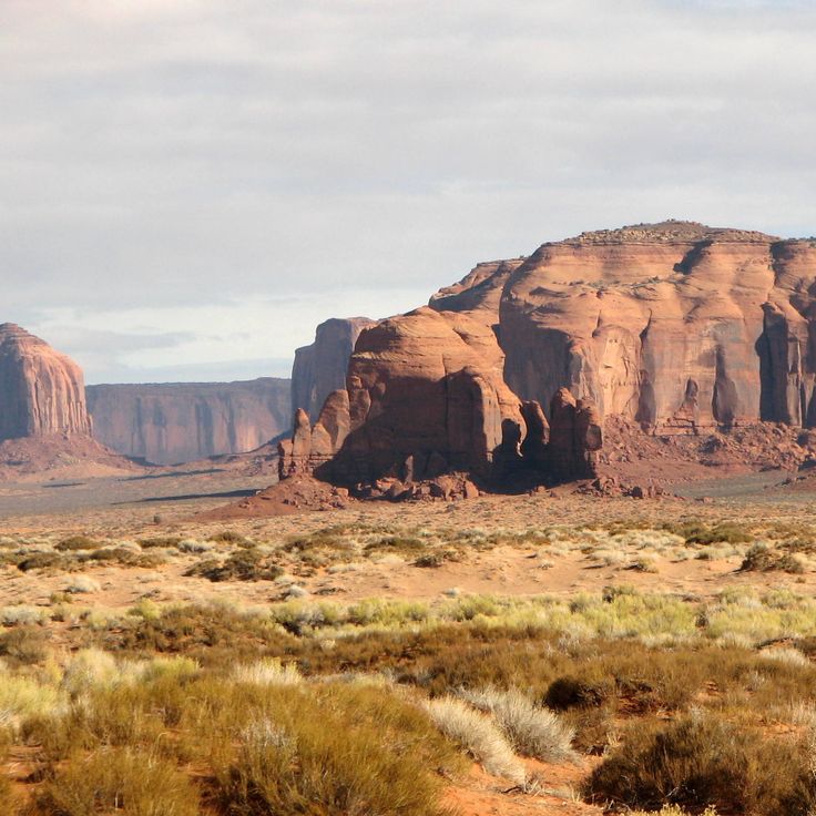
Mystery Valley preserves the remains of 12th-century settlements with petroglyphs and stone structures from the Anasazi culture. This geological formation in the American Southwest lies within Navajo Nation territory and features archaeological sites set among desert landscapes of sandstone formations. The valley contains rock engravings and dwellings that provide insights into the prehistoric occupation of the region. The stone buildings and rock art document the history of Native American inhabitants in this zone of Arizona.
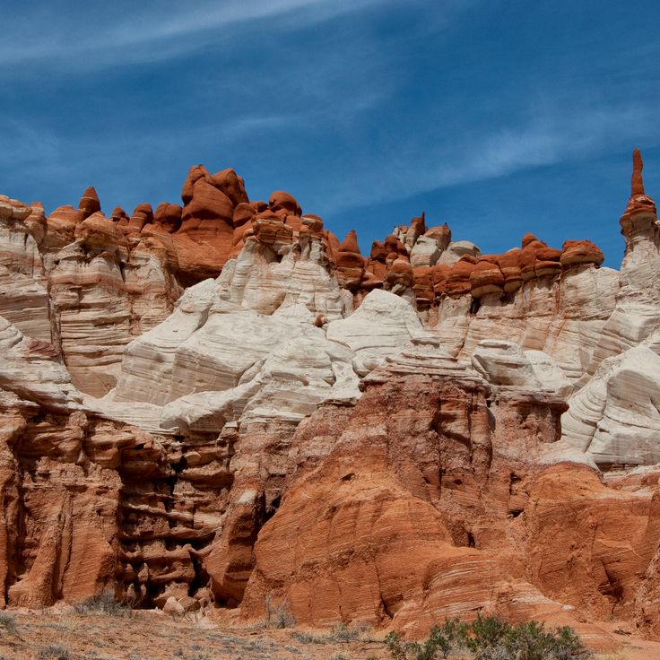
This canyon on the Hopi Reservation displays sandstone formations in blue and gray tones, shaped by erosion over millions of years. The geological structures of Blue Canyon show the characteristic sediment layers of the American Southwest and provide insight into the geological development of the region. The color variations in the rock result from different mineral compositions and oxidation processes. As part of Arizona's natural areas, this formation documents the complex geological processes that have shaped the desert landscapes of the state.
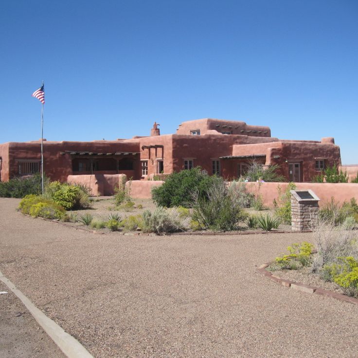
This adobe building from 1924 stands in the Painted Desert and originally served as a trading post and lodging for travelers. The structure was later remodeled in Pueblo Revival style and now displays exhibitions about the geology, history, and culture of the region. The interior contains murals by Hopi artists created in the 1940s. The building sits on a rise with views over the colored badlands of the Painted Desert. Collections document the development of tourism along Route 66 and the relationships between indigenous peoples and settlers in northern Arizona.
The Agua Fria National Monument protects 71,000 acres (287 square kilometers) of land near the Agua Fria River, preserving archaeological sites from prehistoric times. The area documents Native American history with more than 450 pueblo ruins and numerous petroglyphs carved on basalt rocks. The landscape combines high plateau grasslands with riparian zones and provides habitat for pronghorn antelope, prairie dogs, and various bird species. Hiking trails lead to the archaeological sites, where settlements from the 13th and 14th centuries are documented. This monument sits between Phoenix and Prescott and demonstrates the transition zone between Sonoran Desert and highland vegetation.
The Sierra Ancha Wilderness covers 20,850 acres in the Tonto National Forest and presents sandstone formations, desert vegetation and archaeological sites from the Salado culture. This wilderness area extends across rugged mountain terrain with elevations ranging from 4,000 to 7,500 feet (1,200 to 2,300 meters) and contains cliff dwellings from the 13th and 14th centuries. The landscape combines pine forests in the higher elevations with cacti and mesquite trees in the valleys and displays the geological layers of central Arizona.
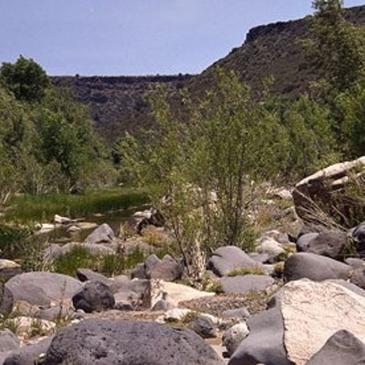
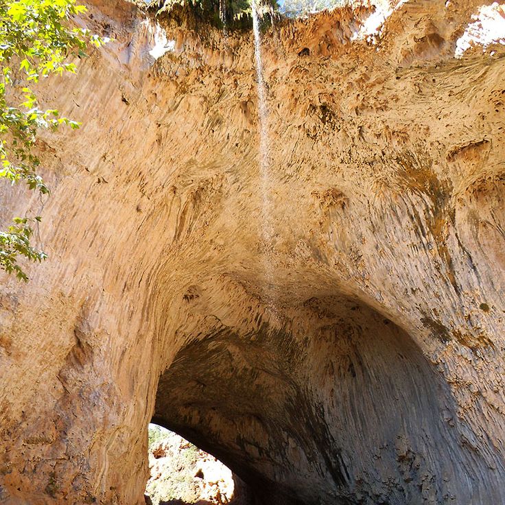
Tonto Natural Bridge State Park protects a travertine arch formed by calcium carbonate deposits from spring water. The bridge rises 183 feet (56 meters) above Pine Creek and developed through mineral accumulation over several thousand years. Trails lead to observation points at the upper and lower sections of the formation, where visitors can view the travertine deposits and the vegetation in the valley below. This park in central Arizona presents a geological structure shaped by mineral-rich water flowing through the limestone rock layers.
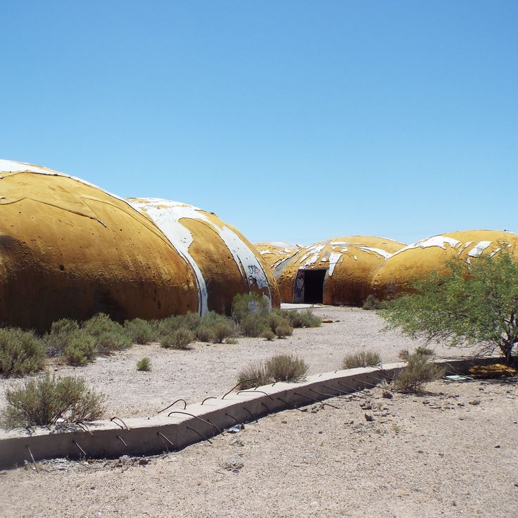
The Abandoned Domes of Casa Grande are circular concrete structures built in 1983 that remain incomplete in the Arizona desert. These buildings stand on private property and represent an architectural experiment with round construction forms. The structures form part of Arizona's geological formations and historic sites, documenting an attempt at alternative building methods in the American Southwest. The domes consist of poured concrete and create several connected circular buildings that were never completed due to changed plans. The site illustrates the development of desert architecture and experimental construction projects in the region.
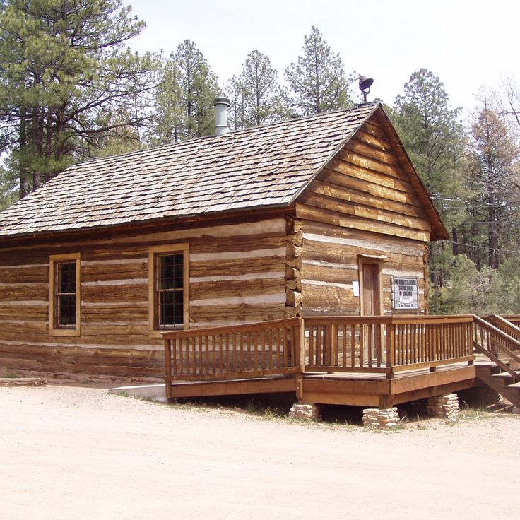
The Strawberry Schoolhouse is a wooden single-room school building constructed in 1885 in Gila County. This historic structure now functions as a museum dedicated to early Arizona education history. The building contains period school furnishings, teaching materials, and documents from the pioneer era. This schoolhouse represents one of the oldest surviving educational facilities in the region and illustrates the challenges of providing education in remote settlements of the American Southwest during the late 19th century.
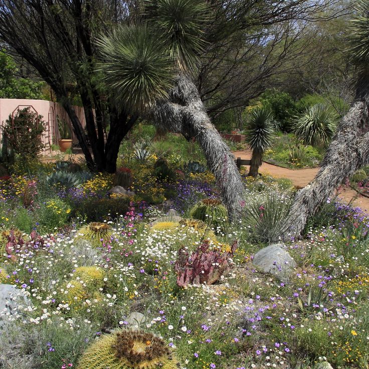
This botanical garden spans 323 acres and houses more than 3900 plant species from desert regions worldwide. The Boyce Thompson Arboretum was established in 1924 as a research facility for dryland vegetation and sits at the base of the Picketpost Mountains. The grounds present collections of cacti, succulents and other plants adapted to arid conditions. Several themed gardens display flora from different desert ecosystems, including the Sonoran Desert, Australian drylands and South African regions. A permanent stream runs through the property, creating a riparian zone amid the desert landscape.
Oracle State Park covers 4,000 acres (1,619 hectares) in the transition zone between Sonora Desert and highland vegetation. This park preserves the historic Kannally Ranch from the 1930s and offers 15 miles (24 kilometers) of marked hiking trails through grassland and oak woodland. The ranch serves as a center for environmental education and documents the history of cattle ranching in Arizona. The trails lead through different elevations with distinct ecosystems where visitors can observe the regional vegetation and wildlife.
This district in the eastern section of the park covers approximately 67,000 acres (27,000 hectares) and ranges from 2,700 feet to 8,666 feet (823 to 2,641 meters) in elevation. The Rincon Mountains display a sequence of vegetation zones from Sonoran Desert lowlands with saguaro cacti through grasslands and oak woodlands to pine forests on the higher ridges. The area contains geological formations of metamorphic and igneous rock, as well as trails that traverse different ecological zones. The Douglas Spring Trail and Tanque Verde Ridge Trail provide access to the upper elevations where Douglas fir and ponderosa pine grow.
These caverns extend 210 feet (64 meters) below ground and are among the driest cave systems in Arizona. The Grand Canyon Caverns formed approximately 65 million years ago through limestone deposits and feature well-preserved geological formations due to the absence of moisture. Visitors can join guided tours that lead through multiple chambers and provide insights into the geological history of the region. The caverns are located along historic Route 66 between Peach Springs and Seligman.
This 1916 historic property displays the history of copper mining and daily life in an early 20th century mining town in Arizona. Jerome State Historic Park occupies the Douglas Mansion and presents exhibits about mining technology, working conditions for miners, and the social development of the community during the copper mining boom in the region. The collection includes mining equipment, historical photographs, and objects from the daily life of residents.
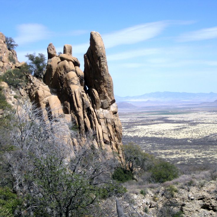
This granite formation in Coronado National Forest served as a defensive position for the Chiricahua Apache between 1860 and 1886. Cochise Stronghold consists of rock walls and valleys in the Dragoon Mountains. The steep granite cliffs and narrow canyons provided natural protection during conflicts with US troops. The area sits at elevations of about 5000 to 7000 feet (roughly 1500 to 2100 meters) and displays the geological features of southeastern Arizona mountain ranges. Trails lead through the rock formations to the historic Apache sites.
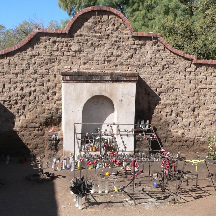
El Tiradito is a 19th century Mexican shrine in Pima County that demonstrates the religious significance for the local community. This shrine contains candles and a well where visitors leave notes with wishes. The site represents one of Arizona's historical locations and illustrates the cultural connections between Spanish-Mexican traditions and the development of the American Southwest. El Tiradito documents the religious practices of the Mexican population in this region and continues to serve as a place of devotion.
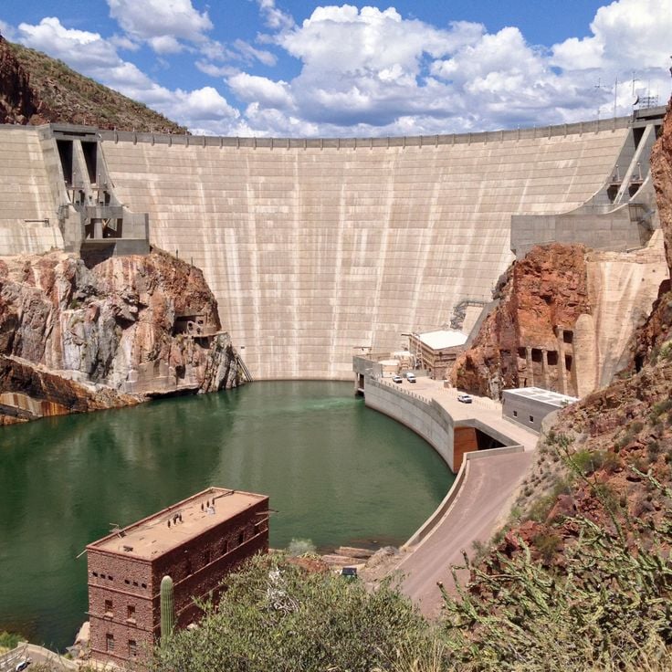
This concrete dam was built in 1911 and rises 280 feet (85 meters) above the Salt River. The Roosevelt Dam regulates water flow into Roosevelt Lake and forms an important element of the region's water supply system. The structure represents early engineering achievements in the American Southwest and fits within Arizona's geological formations that this guide documents. The dam serves irrigation and power generation purposes in Gila County.
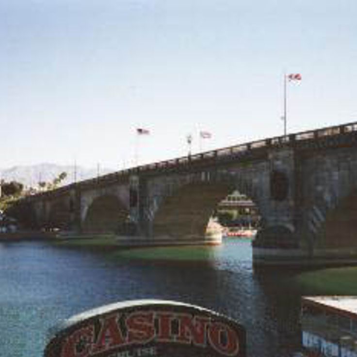
This stone bridge from 1831 was purchased for $2.5 million in 1967 and transported stone by stone to Arizona. The London Bridge was rebuilt at Lake Havasu as part of an urban development project and fitted with an artificial channel running beneath its arches. Originally spanning the Thames in England, the bridge was replaced by a modern structure and its historic material reused in the United States. The bridge displays elements of 19th-century engineering and now serves as a pedestrian crossing over the artificially created waterway. The structure is part of the tourist infrastructure of Lake Havasu City and connects the mainland to an island in the reservoir.
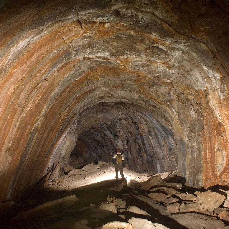
This cave in Coconino County formed through lava flows and extends for one mile (1.6 kilometers) beneath the surface. The tube developed when the outer layer of lava solidified while molten material continued flowing inside. The temperature within the cave remains constant at approximately 42°F (5°C), providing contrast to the changing conditions at the surface. The tunnel displays various volcanic formations along the walls and ceiling. This geological structure is part of Northern Arizona's volcanic landscape and offers insight into the processes that shaped the terrain.
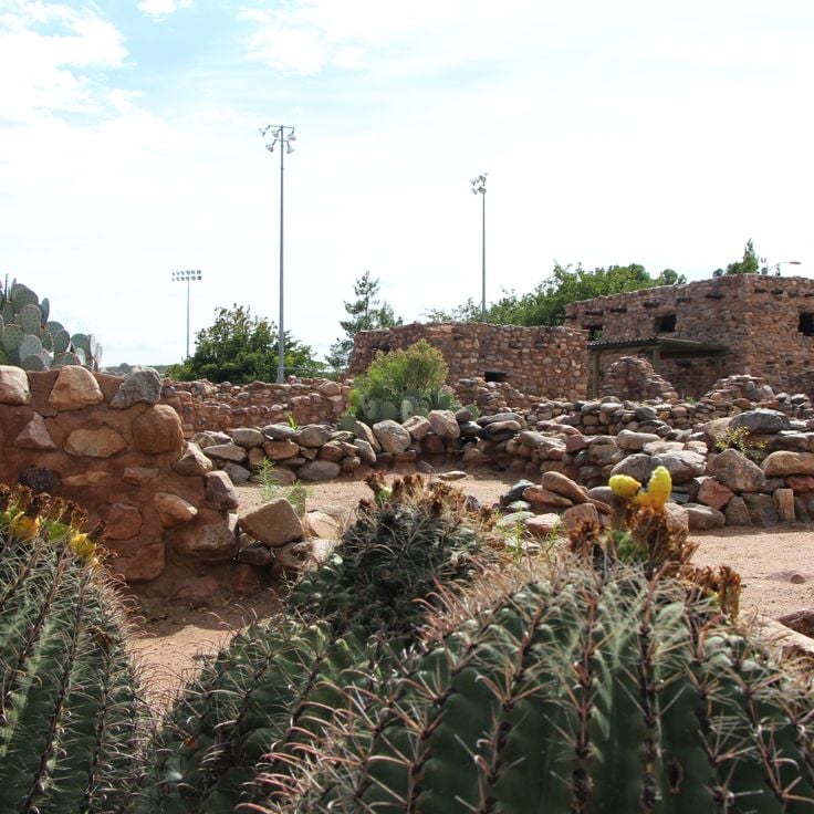
Besh-Ba-Gowah Archaeological Park presents a 700-year-old settlement of the Salado culture from the 13th century, featuring partially restored stone walls, residential structures and a museum. This archaeological site displays over 200 rooms that originally stood up to three stories tall. Excavated ceramics, stone tools and everyday objects document the life of this community along the upper Gila River. This archaeological park represents one of Arizona's significant pre-Columbian sites, providing insight into the construction methods, craftsmanship and daily life of the Salado people who inhabited the area between 1225 and 1400.
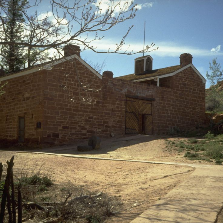
Pipe Spring National Monument preserves a stone fort from the 1800s that served settlers as a protective structure and water source. The springs supplied residents with water in this dry region of Mohave County, while the thick stone walls provided protection from raids. Today, this monument presents the history of early settlement in Arizona and documents the importance of water sources for survival in the desert landscapes of the American Southwest. The preserved gardens and buildings illustrate the lives of pioneers in this remote frontier region.
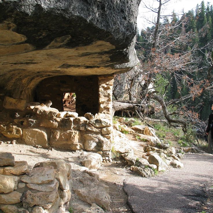
This national monument preserves a 600-foot (183-meter) deep canyon containing over 80 prehistoric dwellings of the Sinagua culture, built into the rock walls between the 12th and 13th centuries. The cliff dwellings occupy natural limestone overhangs along the canyon walls and demonstrate the adaptation of indigenous populations to the harsh environment of the Colorado Plateau. Walnut Canyon National Monument documents the archaeological history of this Arizona region and provides access to several preserved structures through a trail system that follows the cliff edges and offers insight into the lives of the former inhabitants.
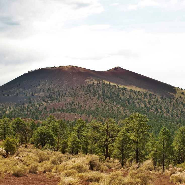
Sunset Crater Volcano National Monument protects the remains of an extinct volcano that erupted in 1085 and left behind black lava fields and volcanic deposits. This volcano is among Arizona's geological formations and demonstrates the volcanic activity of the American Southwest. The landscape consists of basalt flows, cinder cones and cooled lava formations that originated from the eruption nearly a thousand years ago. The site documents volcanic processes and their effects on the surrounding environment. The crater rises above the surrounding plains and provides insight into the geological history of the region.
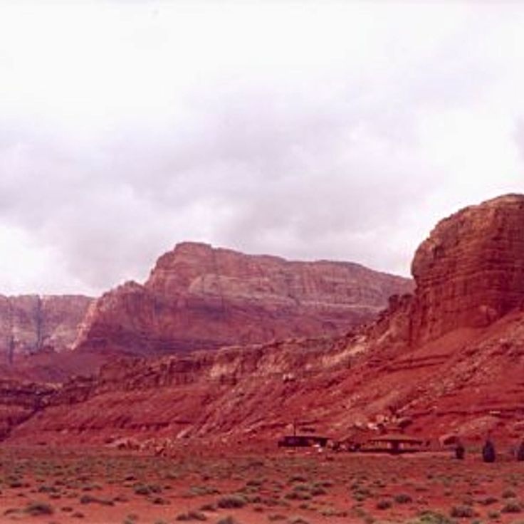
These sandstone cliffs extend across the Colorado Plateau and reach heights of 3,000 feet (914 meters). The Vermilion Cliffs consist of red sandstone that has been shaped by erosion processes over millions of years. The geological formations display layering from different geological periods and document the landscape development of the American Southwest. The area belongs to the sandstone formations of Arizona that received their characteristic shapes through wind and water erosion. The cliffs form part of an extensive rock formation that stretches through northern Arizona.
This sandstone formation developed through natural erosion processes over millions of years. The undulating structures display horizontally bedded layers of consolidated sand from the Navajo Formation, deposited during the Jurassic period approximately 190 million years ago. The formations sit in the northern part of Arizona near the Utah border and represent geological features of the American Southwest. Access to this area is limited to 64 people per day, and visitors require a permit obtained through a lottery system. The hike to the formation covers roughly 6 miles (10 kilometers) of unmarked terrain without established trails.
This park displays Spanish colonial architecture with mission buildings from the 18th century. The site documents Native American history in Arizona and preserves three mission ruins from the Spanish colonial period. Tumacácori National Historical Park lies in the Santa Cruz River Valley and provides insight into the cultural connections between Spanish missionaries and the Tohono O'odham and Yaqui peoples. The adobe structures show the architectural methods of the colonial period with vaulted ceilings, wall paintings, and an open church nave.
This canyon section lies within the Navajo Nation and displays sandstone formations shaped by water erosion over thousands of years. Daylight enters through narrow openings and creates changing light effects on the undulating rock walls. The geological structures belong to the Navajo Sandstone, deposited approximately 190 million years ago during the Jurassic period. The canyon extends several hundred yards and the passageways measure less than 3 feet (about 1 meter) wide in places. Visitor numbers are lower than in other sections of the Antelope Canyon formation, allowing longer stays in individual areas. These slot canyons formed through periodic flash floods that carved away the soft sandstone rock.
This cave system in Arizona displays underground formations including stalactites, stalagmites and mineral deposits. The system remained hidden until 1974 and maintains a constant temperature of 68 degrees Fahrenheit (20 degrees Celsius) throughout the year. The caverns preserve active formations that continue to grow, including columns and shield formations. Kartchner Caverns State Park provides access to these geological features through guided tours that explain the development of the cave system over thousands of years. This site contributes to the collection of historical and natural areas in Arizona, presenting the underground geology of the region.
Petrified Forest National Park preserves a landscape of fossilized tree trunks dating from the Triassic period approximately 225 million years ago. This collection of geological formations, desert landscapes and historical sites in Arizona presents the fossilized remains of an ancient forest transformed into quartz. The park contains colorful rock formations of the Chinle Formation along with petroglyphs created by Ancestral Puebloans and other indigenous peoples who carved into the rock hundreds of years ago. The park badlands display layers of colored claystone and sandstone spanning several hundred feet (91 to 152 m).
Montezuma Castle National Monument preserves a five-story residential complex from the 12th century built into a natural limestone cave 100 feet (30 meters) above the valley floor. This structure demonstrates the construction methods of the Sinagua people in the Arizona uplands. The archaeological site documents adaptation to the regional topography and represents evidence of pre-Columbian settlement in the American Southwest. Located along Beaver Creek, this complex illustrates the relationship between geological formations and historical land use in Arizona.
This waterfall in the Havasupai Reservation drops approximately 100 feet into turquoise pools. The water gains its distinctive color from high calcium carbonate content dissolved in the rock. Havasu Falls is one of several waterfalls in Havasu Creek Canyon, which flows through the Supai Formation of the Colorado Plateau. Access requires a hike of approximately 10 miles from the trailhead or helicopter transportation. The area is located on Havasupai tribal land and requires advance permits for visitation.
This national monument preserves Anasazi cliff dwellings from the 4th century and agricultural lands used by the Navajo people. The walls of Canyon de Chelly rise up to 1,000 feet (305 meters) from the valley floor and display geological layers of red sandstone. The archaeological sites include White House Ruins and Antelope House, built within alcoves in the rock faces. Several side canyons such as Canyon del Muerto contain additional ruins and rock art. The canyon lies within the Navajo Nation and demonstrates the continuous habitation and use of the area by different cultures over more than 1,500 years.
The Chiricahua National Monument preserves volcanic formations that originated about 27 million years ago. The vertical rock columns, natural stone arches, and balanced boulders formed through erosion of rhyolitic tuff from a caldera eruption. This monument encompasses more than 18 square miles (47 square kilometers) of the Chiricahua Mountains in southeastern Arizona. The rock formations reach heights of up to 200 feet (60 meters), and the area demonstrates geological processes shaped by water, wind, and temperature changes.
This Sonoran Desert preserve covers 517 square miles (1,338 square kilometers) of arid terrain displaying various species of cacti, including the namesake organ pipe cacti with their multiple vertical stems rising in arms. The landscape of Organ Pipe Cactus National Monument encompasses two mountain ranges, flat bajadas, and desert valleys where senita cacti, saguaros, and over 30 other cactus species grow. The area sits along the Arizona-Sonora border and features geological formations of volcanic rock and sedimentary layers formed over 18 million years.
This former copper mining town in the Mule Mountains consists of Victorian buildings clinging to steep hillsides. Bisbee was established in the late 19th century during the mining boom and became one of the world's most productive copper mining operations. The historic downtown preserves hundreds of buildings from this era, including the Copper Queen Hotel and the Phelps Dodge General Office Building. After the mines closed in the 1970s, artists and craftspeople transformed the town into a cultural community. Museums document the mining history and offer tours through underground mine shafts.
Saguaro National Park protects large stands of Saguaro cacti, which grow up to 50 feet (15 meters) tall in the Sonoran Desert environment. This protected area preserves the characteristic vegetation of the region and displays the geological formations of the American Southwest. The park occupies two separate districts east and west of Tucson, providing access to desert landscapes with numerous cactus species and varied plant and animal communities adapted to the extreme conditions of the Sonoran Desert climate.
These falls in Navajo territory drop 185 feet over volcanic rock into a narrow gorge. Grand Falls flows primarily during spring snowmelt and after rainstorms, when the Little Colorado River carries large amounts of reddish sediment. The cascades formed approximately 100,000 years ago when lava flows from nearby Merriam Crater blocked the original river channel, forcing the water to carve a new course over the basalt cliffs. The area lies within the Painted Desert and is part of the Navajo Nation. The falls frequently run dry during summer months, leaving only the exposed volcanic rock formations of layered basalt.
Mystery Valley preserves the remains of 12th-century settlements with petroglyphs and stone structures from the Anasazi culture. This geological formation in the American Southwest lies within Navajo Nation territory and features archaeological sites set among desert landscapes of sandstone formations. The valley contains rock engravings and dwellings that provide insights into the prehistoric occupation of the region. The stone buildings and rock art document the history of Native American inhabitants in this zone of Arizona.
This canyon on the Hopi Reservation displays sandstone formations in blue and gray tones, shaped by erosion over millions of years. The geological structures of Blue Canyon show the characteristic sediment layers of the American Southwest and provide insight into the geological development of the region. The color variations in the rock result from different mineral compositions and oxidation processes. As part of Arizona's natural areas, this formation documents the complex geological processes that have shaped the desert landscapes of the state.
This adobe building from 1924 stands in the Painted Desert and originally served as a trading post and lodging for travelers. The structure was later remodeled in Pueblo Revival style and now displays exhibitions about the geology, history, and culture of the region. The interior contains murals by Hopi artists created in the 1940s. The building sits on a rise with views over the colored badlands of the Painted Desert. Collections document the development of tourism along Route 66 and the relationships between indigenous peoples and settlers in northern Arizona.
The Agua Fria National Monument protects 71,000 acres (287 square kilometers) of land near the Agua Fria River, preserving archaeological sites from prehistoric times. The area documents Native American history with more than 450 pueblo ruins and numerous petroglyphs carved on basalt rocks. The landscape combines high plateau grasslands with riparian zones and provides habitat for pronghorn antelope, prairie dogs, and various bird species. Hiking trails lead to the archaeological sites, where settlements from the 13th and 14th centuries are documented. This monument sits between Phoenix and Prescott and demonstrates the transition zone between Sonoran Desert and highland vegetation.
The Sierra Ancha Wilderness covers 20,850 acres in the Tonto National Forest and presents sandstone formations, desert vegetation and archaeological sites from the Salado culture. This wilderness area extends across rugged mountain terrain with elevations ranging from 4,000 to 7,500 feet (1,200 to 2,300 meters) and contains cliff dwellings from the 13th and 14th centuries. The landscape combines pine forests in the higher elevations with cacti and mesquite trees in the valleys and displays the geological layers of central Arizona.
Tonto Natural Bridge State Park protects a travertine arch formed by calcium carbonate deposits from spring water. The bridge rises 183 feet (56 meters) above Pine Creek and developed through mineral accumulation over several thousand years. Trails lead to observation points at the upper and lower sections of the formation, where visitors can view the travertine deposits and the vegetation in the valley below. This park in central Arizona presents a geological structure shaped by mineral-rich water flowing through the limestone rock layers.
The Abandoned Domes of Casa Grande are circular concrete structures built in 1983 that remain incomplete in the Arizona desert. These buildings stand on private property and represent an architectural experiment with round construction forms. The structures form part of Arizona's geological formations and historic sites, documenting an attempt at alternative building methods in the American Southwest. The domes consist of poured concrete and create several connected circular buildings that were never completed due to changed plans. The site illustrates the development of desert architecture and experimental construction projects in the region.
The Strawberry Schoolhouse is a wooden single-room school building constructed in 1885 in Gila County. This historic structure now functions as a museum dedicated to early Arizona education history. The building contains period school furnishings, teaching materials, and documents from the pioneer era. This schoolhouse represents one of the oldest surviving educational facilities in the region and illustrates the challenges of providing education in remote settlements of the American Southwest during the late 19th century.
This botanical garden spans 323 acres and houses more than 3900 plant species from desert regions worldwide. The Boyce Thompson Arboretum was established in 1924 as a research facility for dryland vegetation and sits at the base of the Picketpost Mountains. The grounds present collections of cacti, succulents and other plants adapted to arid conditions. Several themed gardens display flora from different desert ecosystems, including the Sonoran Desert, Australian drylands and South African regions. A permanent stream runs through the property, creating a riparian zone amid the desert landscape.
Oracle State Park covers 4,000 acres (1,619 hectares) in the transition zone between Sonora Desert and highland vegetation. This park preserves the historic Kannally Ranch from the 1930s and offers 15 miles (24 kilometers) of marked hiking trails through grassland and oak woodland. The ranch serves as a center for environmental education and documents the history of cattle ranching in Arizona. The trails lead through different elevations with distinct ecosystems where visitors can observe the regional vegetation and wildlife.
This district in the eastern section of the park covers approximately 67,000 acres (27,000 hectares) and ranges from 2,700 feet to 8,666 feet (823 to 2,641 meters) in elevation. The Rincon Mountains display a sequence of vegetation zones from Sonoran Desert lowlands with saguaro cacti through grasslands and oak woodlands to pine forests on the higher ridges. The area contains geological formations of metamorphic and igneous rock, as well as trails that traverse different ecological zones. The Douglas Spring Trail and Tanque Verde Ridge Trail provide access to the upper elevations where Douglas fir and ponderosa pine grow.
These caverns extend 210 feet (64 meters) below ground and are among the driest cave systems in Arizona. The Grand Canyon Caverns formed approximately 65 million years ago through limestone deposits and feature well-preserved geological formations due to the absence of moisture. Visitors can join guided tours that lead through multiple chambers and provide insights into the geological history of the region. The caverns are located along historic Route 66 between Peach Springs and Seligman.
This 1916 historic property displays the history of copper mining and daily life in an early 20th century mining town in Arizona. Jerome State Historic Park occupies the Douglas Mansion and presents exhibits about mining technology, working conditions for miners, and the social development of the community during the copper mining boom in the region. The collection includes mining equipment, historical photographs, and objects from the daily life of residents.
This granite formation in Coronado National Forest served as a defensive position for the Chiricahua Apache between 1860 and 1886. Cochise Stronghold consists of rock walls and valleys in the Dragoon Mountains. The steep granite cliffs and narrow canyons provided natural protection during conflicts with US troops. The area sits at elevations of about 5000 to 7000 feet (roughly 1500 to 2100 meters) and displays the geological features of southeastern Arizona mountain ranges. Trails lead through the rock formations to the historic Apache sites.
El Tiradito is a 19th century Mexican shrine in Pima County that demonstrates the religious significance for the local community. This shrine contains candles and a well where visitors leave notes with wishes. The site represents one of Arizona's historical locations and illustrates the cultural connections between Spanish-Mexican traditions and the development of the American Southwest. El Tiradito documents the religious practices of the Mexican population in this region and continues to serve as a place of devotion.
This concrete dam was built in 1911 and rises 280 feet (85 meters) above the Salt River. The Roosevelt Dam regulates water flow into Roosevelt Lake and forms an important element of the region's water supply system. The structure represents early engineering achievements in the American Southwest and fits within Arizona's geological formations that this guide documents. The dam serves irrigation and power generation purposes in Gila County.
This stone bridge from 1831 was purchased for $2.5 million in 1967 and transported stone by stone to Arizona. The London Bridge was rebuilt at Lake Havasu as part of an urban development project and fitted with an artificial channel running beneath its arches. Originally spanning the Thames in England, the bridge was replaced by a modern structure and its historic material reused in the United States. The bridge displays elements of 19th-century engineering and now serves as a pedestrian crossing over the artificially created waterway. The structure is part of the tourist infrastructure of Lake Havasu City and connects the mainland to an island in the reservoir.
This cave in Coconino County formed through lava flows and extends for one mile (1.6 kilometers) beneath the surface. The tube developed when the outer layer of lava solidified while molten material continued flowing inside. The temperature within the cave remains constant at approximately 42°F (5°C), providing contrast to the changing conditions at the surface. The tunnel displays various volcanic formations along the walls and ceiling. This geological structure is part of Northern Arizona's volcanic landscape and offers insight into the processes that shaped the terrain.
Besh-Ba-Gowah Archaeological Park presents a 700-year-old settlement of the Salado culture from the 13th century, featuring partially restored stone walls, residential structures and a museum. This archaeological site displays over 200 rooms that originally stood up to three stories tall. Excavated ceramics, stone tools and everyday objects document the life of this community along the upper Gila River. This archaeological park represents one of Arizona's significant pre-Columbian sites, providing insight into the construction methods, craftsmanship and daily life of the Salado people who inhabited the area between 1225 and 1400.
Pipe Spring National Monument preserves a stone fort from the 1800s that served settlers as a protective structure and water source. The springs supplied residents with water in this dry region of Mohave County, while the thick stone walls provided protection from raids. Today, this monument presents the history of early settlement in Arizona and documents the importance of water sources for survival in the desert landscapes of the American Southwest. The preserved gardens and buildings illustrate the lives of pioneers in this remote frontier region.
This national monument preserves a 600-foot (183-meter) deep canyon containing over 80 prehistoric dwellings of the Sinagua culture, built into the rock walls between the 12th and 13th centuries. The cliff dwellings occupy natural limestone overhangs along the canyon walls and demonstrate the adaptation of indigenous populations to the harsh environment of the Colorado Plateau. Walnut Canyon National Monument documents the archaeological history of this Arizona region and provides access to several preserved structures through a trail system that follows the cliff edges and offers insight into the lives of the former inhabitants.
Sunset Crater Volcano National Monument protects the remains of an extinct volcano that erupted in 1085 and left behind black lava fields and volcanic deposits. This volcano is among Arizona's geological formations and demonstrates the volcanic activity of the American Southwest. The landscape consists of basalt flows, cinder cones and cooled lava formations that originated from the eruption nearly a thousand years ago. The site documents volcanic processes and their effects on the surrounding environment. The crater rises above the surrounding plains and provides insight into the geological history of the region.
These sandstone cliffs extend across the Colorado Plateau and reach heights of 3,000 feet (914 meters). The Vermilion Cliffs consist of red sandstone that has been shaped by erosion processes over millions of years. The geological formations display layering from different geological periods and document the landscape development of the American Southwest. The area belongs to the sandstone formations of Arizona that received their characteristic shapes through wind and water erosion. The cliffs form part of an extensive rock formation that stretches through northern Arizona.