Kartchner Caverns State Park
Kartchner Caverns State Park, Show cave and state park in Cochise County, Arizona.
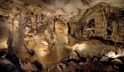
The limestone caves contain numerous mineral formations, including stalactites and stalagmites that have formed over thousands of years through water deposits.
Two cavers discovered these caves in November 1974 and kept their existence secret for four years to protect them from potential damage.
The park serves as an educational center where visitors learn about cave formation, geological processes, and the importance of cave conservation.
The park maintains specific temperature and humidity levels inside the caves to preserve the formations and offers guided tours with advance reservations.
The caverns provide a habitat for over 1000 bats in the summer months and feature the world's longest known soda straw stalactite.
Location: Cochise County
Inception: 1988
Official opening: November 5, 1999
Operator: Arizona State Parks
Website: https://azstateparks.com/kartchner
GPS coordinates: 31.83750,-110.34722
Latest update: May 26, 2025 21:43
Arizona contains geological formations spanning millions of years alongside evidence of Spanish colonial settlement and prehistoric cultures. The landscape includes sandstone canyons such as Antelope Canyon X and Canyon de Chelly National Monument, extensive desert areas with saguaro and organ pipe cacti, and volcanic remnants at Sunset Crater. Historical sites include Spanish missions like Tumacácori, pueblo ruins at Montezuma Castle, and mining towns such as Bisbee and Jerome. The state holds significant paleontological sites at Petrified Forest National Park, where fossilized tree trunks from the Triassic period lie exposed, and cave systems like Kartchner Caverns with active speleothem formations. The Vermilion Cliffs region displays layered sandstone formations including The Wave, while the Chiricahua Mountains show volcanic rock pinnacles formed from welded ash. Waterfalls such as Havasu Falls and Grand Falls result from geological faulting and seasonal water flow. Archaeological sites document occupation by the Hohokam, Sinagua, and Ancestral Puebloans between 300 and 1400 CE. Tonto Natural Bridge forms one of the largest travertine bridges in North America, while Besh-Ba-Gowah shows Salado culture construction methods from the 13th century. The territory spans from the Sonoran Desert in the south to the Colorado Plateau in the north, creating distinct climate zones and ecosystems within a compact area.
Fort Huachuca
31.4 km
Bird Cage Theatre
30.1 km
Empire Ranch
28.5 km
Texas Canyon
33.3 km
Colossal Cave
36.9 km
Schieffelin Hall
30 km
Kentucky Camp
37.8 km
Tombstone Courthouse
29.8 km
Murray Springs Clovis Site
33.7 km
San Pedro Riparian National Conservation Area
35 km
Las Cienegas National Conservation Area
25.1 km
Tombstone Historic District
30 km
Presidio Santa Cruz de Terrenate
16.8 km
Amerind Foundation
34.3 km
Apache Peak
7.9 km
Ciénega Bridge
34.8 km
Canelo Hills Cienega Reserve
35 km
Mae West Peaks
36.1 km
J.H. Smith Grocery Store and Filling Station
36.1 km
Canelo School
36.4 km
Canelo Ranger Station
35.7 km
Lime Peak
38.8 km
Benson Railroad Historic District
15.5 km
Apache Powder Historic Residential District
15.1 km
San Pedro Golf Course
16.9 km
Marsh Station Bridge
34.8 km
Fairbank Railroad Bridge
18.7 km
San Pedro River Railroad Bridge
15.6 kmReviews
Visited this place? Tap the stars to rate it and share your experience / photos with the community! Try now! You can cancel it anytime.
Discover hidden gems everywhere you go!
From secret cafés to breathtaking viewpoints, skip the crowded tourist spots and find places that match your style. Our app makes it easy with voice search, smart filtering, route optimization, and insider tips from travelers worldwide. Download now for the complete mobile experience.
A unique approach to discovering new places❞
— Le Figaro
All the places worth exploring❞
— France Info
A tailor-made excursion in just a few clicks❞
— 20 Minutes