Strawberry Schoolhouse
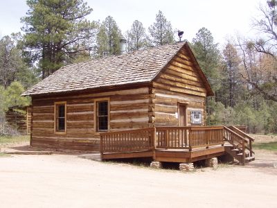
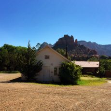
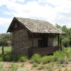
Strawberry Schoolhouse, Historic schoolhouse in Strawberry, Arizona.
The single-room pine log structure measures 30 feet by 20 feet, featuring a sandstone foundation and ponderosa pine walls near State Route 87.
Built in 1885 during Arizona's territorial period, the schoolhouse operated until 1916 when student enrollment decreased, leading to its closure.
The building served multiple functions for the community, operating as an educational facility, dance hall, church, and meeting house throughout its active years.
The Pine-Strawberry Archaeological and Historical Society maintains the structure as a museum, displaying original furnishings and educational materials from the 1800s.
The schoolhouse interior contains factory-made double desks, a large blackboard, Webster's dictionary, and a pump organ from its operational period.
Location: Arizona
GPS coordinates: 34.40580,-111.51900
Latest update: March 8, 2025 03:11
Arizona contains geological formations spanning millions of years alongside evidence of Spanish colonial settlement and prehistoric cultures. The landscape includes sandstone canyons such as Antelope Canyon X and Canyon de Chelly National Monument, extensive desert areas with saguaro and organ pipe cacti, and volcanic remnants at Sunset Crater. Historical sites include Spanish missions like Tumacácori, pueblo ruins at Montezuma Castle, and mining towns such as Bisbee and Jerome. The state holds significant paleontological sites at Petrified Forest National Park, where fossilized tree trunks from the Triassic period lie exposed, and cave systems like Kartchner Caverns with active speleothem formations. The Vermilion Cliffs region displays layered sandstone formations including The Wave, while the Chiricahua Mountains show volcanic rock pinnacles formed from welded ash. Waterfalls such as Havasu Falls and Grand Falls result from geological faulting and seasonal water flow. Archaeological sites document occupation by the Hohokam, Sinagua, and Ancestral Puebloans between 300 and 1400 CE. Tonto Natural Bridge forms one of the largest travertine bridges in North America, while Besh-Ba-Gowah shows Salado culture construction methods from the 13th century. The territory spans from the Sonoran Desert in the south to the Colorado Plateau in the north, creating distinct climate zones and ecosystems within a compact area.
Oak Creek Canyon
59.5 km
Cathedral Rock
52.5 km
Red Rock State Park
53.6 km
Tonto Natural Bridge
11.2 km
Bell Rock
49.4 km
Blue Ridge Reservoir
32.3 km
Dead Horse Ranch State Park
59.4 km
Out of Africa Wildlife Park
43.7 km
Discovery Channel Telescope
38.7 km
Wet Beaver Wilderness
15.4 km
Fort Verde State Historic Park
35.4 km
Childs-Irving Hydroelectric Facilities
17.7 km
Courthouse Butte
49.1 km
V-Bar-V Heritage Site
33.8 km
Fossil Springs Wilderness
5.3 km
Verde River Sheep Bridge
40.4 km
Tonto Natural Bridge State Park
11.1 km
Fossil Creek Bridge
10.2 km
Beaver Creek Ranger Station
34.6 km
Clear Creek Church
31.3 km
Sedona Ranger Station
55.6 km
Copper Creek Guard Station
47.3 km
Master Mechanic's House
59.1 km
Sedona Heritage Museum
57.1 km
Verde Valley Archaeology Center and Museum
36.2 km
Midgley Bridge
57.2 km
Moqui Lookout
36.7 km
Apache Maid Lookout
35.7 kmReviews
Visited this place? Tap the stars to rate it and share your experience / photos with the community! Try now! You can cancel it anytime.
Discover hidden gems everywhere you go!
From secret cafés to breathtaking viewpoints, skip the crowded tourist spots and find places that match your style. Our app makes it easy with voice search, smart filtering, route optimization, and insider tips from travelers worldwide. Download now for the complete mobile experience.
A unique approach to discovering new places❞
— Le Figaro
All the places worth exploring❞
— France Info
A tailor-made excursion in just a few clicks❞
— 20 Minutes