Enable Location

We need your location to show you interesting places around you

Discover nearby places

Find interesting locations and hidden gems around you

Precise directions

Get accurate directions and distances to places

Your location is never shared with other users. It's only used when you tap the location button.

Beaver Creek Ranger Station

Log in to your account

Start exploring — it's free

Trusted by 62,465 travelers worldwide

Continue with Google
Continue with Apple
or

We will send you a code to connect

By continuing, you accept our Terms and Conditions and our Privacy Policy

Check your inbox

We've sent a pincode in your inbox. Please enter the code below.

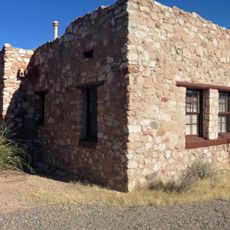
Beaver Creek Ranger Station, Forest Service station in Rimrock, United States

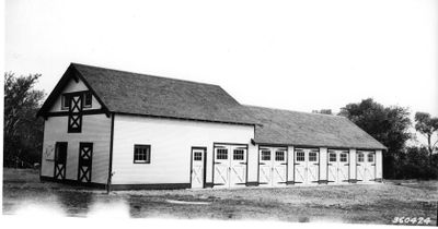
Beaver Creek Ranger Station is a forest management complex with three main buildings and two additional structures on a large property near Rimrock in Arizona. The facility includes a ranger office, residential quarters, and a maintenance building for equipment and upkeep work.

The station was built in 1935 by the Civilian Conservation Corps, a Depression-era program that employed young men on public land projects. It was added to the National Register of Historic Places in 1993 as a significant example from that period.

The buildings show the simple, practical design style common to Forest Service structures from that era. You can see this in the windows, woodwork, and how the structures are put together.

The complex sits northeast of Rimrock near Interstate 17 and is easily accessible by car. The grounds are open to view, with the buildings visible from outside, allowing visitors to see the historic structures in their original setting.

The station preserves the original building arrangement and land layout from the 1930s. This gives visitors a rare view of how the Forest Service designed and organized its administrative compounds in that era.

The community of curious travelers

AroundUs brings together thousands of curated places, local tips, and hidden gems, enriched daily by 60,000 contributors worldwide.

Start exploring
Location
Architects
United States Forest Service
GPS coordinates
34.67278,-111.71139
Latest update
December 14, 2025 18:07
Around this place
Oak Creek Canyon
United States of America

Oak Creek Canyon

26.7 km
Cathedral Rock
United States of America

Cathedral Rock

18 km
Slide Rock State Park
United States of America

Slide Rock State Park

27.1 km
Red Rock State Park
United States of America

Red Rock State Park

19.1 km
Tuzigoot National Monument
United States of America

Tuzigoot National Monument

30.8 km
Bell Rock
United States of America

Bell Rock

15 km
Dead Horse Ranch State Park
United States of America

Dead Horse Ranch State Park

28.9 km
Out of Africa Wildlife Park
United States of America

Out of Africa Wildlife Park

20.6 km
Discovery Channel Telescope
United States of America

Discovery Channel Telescope

27.7 km
Fort Verde State Historic Park
United States of America

Fort Verde State Historic Park

17.6 km
Courthouse Butte
United States of America

Courthouse Butte

14.9 km
V-Bar-V Heritage Site
United States of America

V-Bar-V Heritage Site

1.5 km
Fossil Springs Wilderness
United States of America

Fossil Springs Wilderness

29.3 km
Fossil Creek Bridge
United States of America

Fossil Creek Bridge

31.9 km
Strawberry Schoolhouse
United States of America

Strawberry Schoolhouse

34.6 km
Clear Creek Church
United States of America

Clear Creek Church

19.6 km
Sedona Ranger Station
United States of America

Sedona Ranger Station

21.7 km
Clarkdale Historic District
United States of America

Clarkdale Historic District

33.7 km
Master Mechanic's House
United States of America

Master Mechanic's House

29.6 km
Willard House
United States of America

Willard House

30.3 km
Sedona Heritage Museum
United States of America

Sedona Heritage Museum

23.4 km
Tuzigoot Museum
United States of America

Tuzigoot Museum

30.8 km
Devil's Bridge, Sedona
United States of America

Devil's Bridge, Sedona

26.7 km
Verde Valley Archaeology Center and Museum
United States of America

Verde Valley Archaeology Center and Museum

18.2 km
Clark Memorial Clubhouse
United States of America

Clark Memorial Clubhouse

33.5 km
Midgley Bridge
United States of America

Midgley Bridge

23.8 km
Apache Maid Lookout
United States of America

Apache Maid Lookout

15.8 km
Broadway Street Bridge
United States of America

Broadway Street Bridge

33.5 km
Show the full map
« Beaver Creek Ranger Station - Forest Service station in Rimrock, United States » is provided by Around Us (aroundus.com). Images and texts are derived from Wikimedia project under a Creative Commons license. You are allowed to copy, distribute, and modify copies of this page, under the conditions set by the license, as long as this note is clearly visible.

Discover hidden gems everywhere you go!

From secret cafés to breathtaking viewpoints, skip the crowded tourist spots and find places that match your style. Our app makes it easy with voice search, smart filtering, route optimization, and insider tips from travelers worldwide. Download now for the complete mobile experience.

Around Us App Screenshot

A unique approach to discovering new places

Le Figaro

All the places worth exploring

France Info

A tailor-made excursion in just a few clicks

20 Minutes

Around Us
Travel Guide & Maps
Download

Send to your phone

QR Code
1

Open the camera app on your mobile.

2

Point at the QR code with your camera. A notification will appear.

3

Tap the notification to open the link.