Tonto Natural Bridge State Park

Log in to your account

AroundUs is a community-driven map of interesting places, built by curious explorers like you. It grows with every review, story, and photo you share.
Connect to save your favorite spots, contribute locations, and create personalized routes.
Continue with Google
Continue with Apple
Continue with X
Continue with Facebook
Continue with email
By continuing, you accept our Terms and Conditions and our Privacy Policy
Create an account

Tonto Natural Bridge State Park

Add to collection
Map
Suggest a change
Share

Tonto Natural Bridge State Park, Natural travertine bridge park in Gila County, United States.

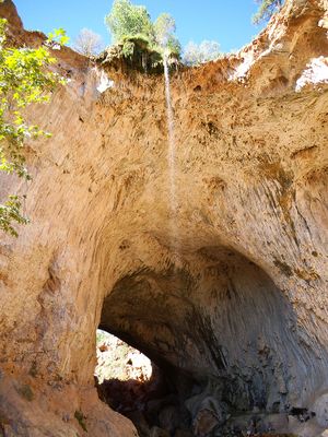
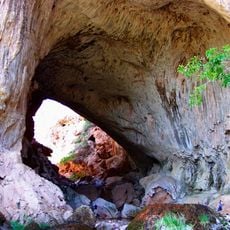
Tonto Natural Bridge State Park features a massive limestone arch that rises 180 feet above a tunnel carved through the rock, spanning roughly 150 feet across. This formation stands over a creek where several marked trails guide visitors through the landscape to view the bridge from different angles.

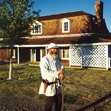
A Scottish prospector discovered the bridge in 1877 while fleeing Apache raiders and subsequently claimed the land through homesteading rights. His settlement marked the beginning of European presence in this remote canyon area.

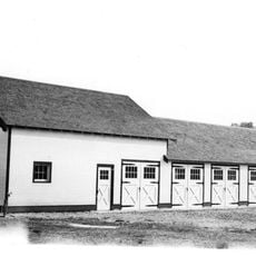
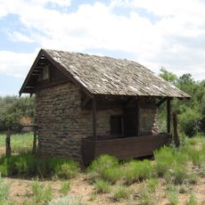
The historic Goodfellow Lodge functions as a visitor center today, showing how early settlers lived in this remote location. Visitors can observe the way the house was built and used, reflecting the pioneering spirit of those who stayed here.

The park has four hiking trails with varying difficulty levels, all clearly marked and accessible from the visitor center. Wear sturdy shoes and bring plenty of water, as some paths are steep and shaded, offering protection from the sun during hot seasons.

The limestone arch formed over thousands of years through an unusual combination of volcanic lava and seawater that created a durable dam-like structure. This geological process is difficult to see today, but it shaped the landscape in ways that most visitors never fully understand when they first arrive.

Location: Gila County

Website: https://azstateparks.com/tonto

GPS coordinates: 34.32056,-111.45667

Latest update: December 6, 2025 17:46

Photos
Natural areas and historic sites in Arizona

Arizona contains geological formations spanning millions of years alongside evidence of Spanish colonial settlement and prehistoric cultures. The landscape includes sandstone canyons such as Antelope Canyon X and Canyon de Chelly National Monument, extensive desert areas with saguaro and organ pipe...

Around this place
Cathedral Rock
United States of America

Cathedral Rock

63.6 km
Red Rock State Park
United States of America

Red Rock State Park

64.7 km
Tonto Natural Bridge
United States of America

Tonto Natural Bridge

100 m
Bell Rock
United States of America

Bell Rock

60.4 km
Blue Ridge Reservoir
United States of America

Blue Ridge Reservoir

33.5 km
Out of Africa Wildlife Park
United States of America

Out of Africa Wildlife Park

53.8 km
Willow Springs Lake
United States of America

Willow Springs Lake

53.1 km
Discovery Channel Telescope
United States of America

Discovery Channel Telescope

47.3 km
Wet Beaver Wilderness
United States of America

Wet Beaver Wilderness

17.8 km
Fort Verde State Historic Park
United States of America

Fort Verde State Historic Park

45.4 km
Childs-Irving Hydroelectric Facilities
United States of America

Childs-Irving Hydroelectric Facilities

22.5 km
Sears-Kay Ruin
United States of America

Sears-Kay Ruin

55.3 km
Courthouse Butte
United States of America

Courthouse Butte

60.1 km
V-Bar-V Heritage Site
United States of America

V-Bar-V Heritage Site

44.9 km
Fossil Springs Wilderness
United States of America

Fossil Springs Wilderness

16.3 km
Verde River Sheep Bridge
United States of America

Verde River Sheep Bridge

35.6 km
Fossil Creek Bridge
United States of America

Fossil Creek Bridge

17.8 km
Beaver Creek Ranger Station
United States of America

Beaver Creek Ranger Station

45.6 km
Strawberry Schoolhouse
United States of America

Strawberry Schoolhouse

11.1 km
Clear Creek Church
United States of America

Clear Creek Church

41 km
Sedona Ranger Station
United States of America

Sedona Ranger Station

66.7 km
Pleasant Valley Ranger Station
United States of America

Pleasant Valley Ranger Station

52.7 km
Copper Creek Guard Station
United States of America

Copper Creek Guard Station

49.4 km
Sedona Heritage Museum
United States of America

Sedona Heritage Museum

68.1 km
Verde River Golf and Social Club
United States of America

Verde River Golf and Social Club

67.4 km
Verde Valley Archaeology Center and Museum
United States of America

Verde Valley Archaeology Center and Museum

46.2 km
Moqui Lookout
United States of America

Moqui Lookout

37.9 km
Midgley Bridge
United States of America

Midgley Bridge

68.1 km
Show the full map
Reviews

Visited this place? Tap the stars to rate it and share your experience / photos with the community! Try now! You can cancel it anytime.

« Tonto Natural Bridge State Park - Natural travertine bridge park in Gila County, United States » is provided by Around Us (aroundus.com). Images and texts are derived from Wikimedia project under a Creative Commons license. You are allowed to copy, distribute, and modify copies of this page, under the conditions set by the license, as long as this note is clearly visible.

Discover hidden gems everywhere you go!

From secret cafés to breathtaking viewpoints, skip the crowded tourist spots and find places that match your style. Our app makes it easy with voice search, smart filtering, route optimization, and insider tips from travelers worldwide. Download now for the complete mobile experience.

Around Us App Screenshot

A unique approach to discovering new places

Le Figaro

All the places worth exploring

France Info

A tailor-made excursion in just a few clicks

20 Minutes