Enable Location

We need your location to show you interesting places around you

Discover nearby places

Find interesting locations and hidden gems around you

Precise directions

Get accurate directions and distances to places

Your location is never shared with other users. It's only used when you tap the location button.

Willow Springs Lake

Log in to your account

Start exploring — it's free

Trusted by 62,445 travelers worldwide

Continue with Google
Continue with Apple
or

We will send you a code to connect

By continuing, you accept our Terms and Conditions and our Privacy Policy

Check your inbox

We've sent a pincode in your inbox. Please enter the code below.

Willow Springs Lake

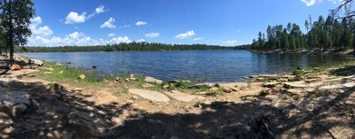
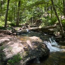
Willow Springs Lake, lake in Coconino County, Arizona, United States of America

Willow Springs Lake is a reservoir in Coconino County situated at about 7,600 feet (2,300 meters) elevation amid tall pine trees. Its water surface covers roughly 150 acres and is ringed by rocky hills and forested shores, creating a calm and natural setting with a paved boat ramp, picnic areas, and shoreline benches for visitors.

The lake was created in 1966 by the Arizona Game and Fish Department to provide a fishing and recreation destination. Since its establishment, it has grown into a popular spot for families and outdoor enthusiasts and is regularly stocked with trout during spring and summer.

The name comes from willow trees that once grew in the area. Today, visitors experience how the lake serves as a gathering place for fishing and water recreation, with families and outdoor enthusiasts using the shoreline picnic areas and boat ramp throughout the seasons.

The lake is open year-round, though access is most convenient during warmer months when facilities are fully operational. Bring your own drinking water since none is provided on-site, and a valid Arizona fishing license is required to fish in the lake.

The lake is part of the Rim Lakes group and is fed primarily by snowmelt, which naturally regulates its water levels without needing irrigation releases. In winter, the surface freezes, transforming it into an ice fishing destination, a rare activity in this region.

The community of curious travelers

AroundUs brings together thousands of curated places, local tips, and hidden gems, enriched daily by 60,000 contributors worldwide.

Start exploring
Location
Elevation above the sea
2,293 m
GPS coordinates
34.30360,-110.87100
Latest update
February 7, 2026 11:01
Around this place
Chevelon Creek Bridge
United States of America

Chevelon Creek Bridge

75.7 km
Tonto Natural Bridge
United States of America

Tonto Natural Bridge

53.9 km
Meteor Crater Natural Landmark
United States of America

Meteor Crater Natural Landmark

81.8 km
Blue Ridge Reservoir
United States of America

Blue Ridge Reservoir

40.3 km
Discovery Channel Telescope
United States of America

Discovery Channel Telescope

70.4 km
Wet Beaver Wilderness
United States of America

Wet Beaver Wilderness

71.7 km
Salt River Canyon Wilderness
United States of America

Salt River Canyon Wilderness

72.5 km
Childs-Irving Hydroelectric Facilities
United States of America

Childs-Irving Hydroelectric Facilities

76.3 km
Snowflake Arizona Temple
United States of America

Snowflake Arizona Temple

73.2 km
Sears-Kay Ruin
United States of America

Sears-Kay Ruin

63.8 km
La Posada Historic District
United States of America

La Posada Historic District

81.5 km
Fossil Springs Wilderness
United States of America

Fossil Springs Wilderness

63.8 km
Roosevelt Lake Bridge
United States of America

Roosevelt Lake Bridge

74.9 km
Verde River Sheep Bridge
United States of America

Verde River Sheep Bridge

81 km
Sierra Ancha Wilderness
United States of America

Sierra Ancha Wilderness

53.6 km
Tonto Natural Bridge State Park
United States of America

Tonto Natural Bridge State Park

53.9 km
Fossil Creek Bridge
United States of America

Fossil Creek Bridge

70.4 km
Cedar Canyon Bridge
United States of America

Cedar Canyon Bridge

66.8 km
Strawberry Schoolhouse
United States of America

Strawberry Schoolhouse

60.6 km
Corduroy Creek Bridge
United States of America

Corduroy Creek Bridge

69.7 km
Pleasant Valley Ranger Station
United States of America

Pleasant Valley Ranger Station

22 km
Horton Creek Trail #285
United States of America

Horton Creek Trail #285

19.9 km
Tonto National Monument Visitor Center
United States of America

Tonto National Monument Visitor Center

76.6 km
Show Low Historical Society
United States of America

Show Low Historical Society

77 km
Aztec Peak Lookout
United States of America

Aztec Peak Lookout

54.8 km
Moqui Lookout
United States of America

Moqui Lookout

39.9 km
Apache Maid Lookout
United States of America

Apache Maid Lookout

78 km
Alchesay Canyon Bridge
United States of America

Alchesay Canyon Bridge

75.6 km
Show the full map
« Willow Springs Lake - lake in Coconino County, Arizona, United States of America » is provided by Around Us (aroundus.com). Images and texts are derived from Wikimedia project under a Creative Commons license. You are allowed to copy, distribute, and modify copies of this page, under the conditions set by the license, as long as this note is clearly visible.

Discover hidden gems everywhere you go!

From secret cafés to breathtaking viewpoints, skip the crowded tourist spots and find places that match your style. Our app makes it easy with voice search, smart filtering, route optimization, and insider tips from travelers worldwide. Download now for the complete mobile experience.

Around Us App Screenshot

A unique approach to discovering new places

Le Figaro

All the places worth exploring

France Info

A tailor-made excursion in just a few clicks

20 Minutes

Around Us
Travel Guide & Maps
Download

Send to your phone

QR Code
1

Open the camera app on your mobile.

2

Point at the QR code with your camera. A notification will appear.

3

Tap the notification to open the link.