Horton Creek Trail #285

Log in to your account

AroundUs is a community-driven map of interesting places, built by curious explorers like you. It grows with every review, story, and photo you share.
Connect to save your favorite spots, contribute locations, and create personalized routes.
By continuing, you accept our Terms and Conditions and our Privacy Policy

Horton Creek Trail #285, Forest hiking trail in Gila County, United States.
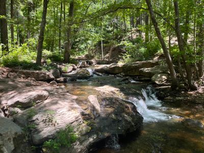
The Horton Creek Trail extends for 7.1 miles through Arizona's natural terrain, following a creek with numerous small waterfalls and clear pools.

The trail incorporates sections of an old jeep path that connected homesteads in the region, including the property of L.J. Horton during early settlement times.

The United States Forest Service maintains this recreational path, which attracts numerous local families and nature enthusiasts throughout mild weather seasons.

Visitors should begin their hike at the concrete bridge parking area, following the paved road toward campgrounds before locating the trailhead on the left side.

The trail features an exceptionally large spring that emerges from the rim's side, supplying water to Horton Creek through underground limestone formations.

Location: Gila County

Operator: United States Forest Service

Address: Nf-289, Payson, AZ 85541, USA 85541 Payson

Website: https://fs.usda.gov/recarea/tonto/recreation/hiking/recarea/?recid=35613&actid=50

GPS coordinates: 34.35504,-111.07809

Latest update: May 3, 2025 12:31

Around this place
Show the full map
Meteor Crater
United States of America

Meteor Crater

75.1 km
Four Peaks
United States of America

Four Peaks

78.1 km
Tonto Natural Bridge
United States of America

Tonto Natural Bridge

35 km
Meteor Crater Natural Landmark
United States of America

Meteor Crater Natural Landmark

75.1 km
Blue Ridge Reservoir
United States of America

Blue Ridge Reservoir

25.1 km
Willow Springs Lake
United States of America

Willow Springs Lake

18.9 km
Discovery Channel Telescope
United States of America

Discovery Channel Telescope

53.6 km
Wet Beaver Wilderness
United States of America

Wet Beaver Wilderness

52.7 km
Fort Verde State Historic Park
United States of America

Fort Verde State Historic Park

74.8 km
Childs-Irving Hydroelectric Facilities
United States of America

Childs-Irving Hydroelectric Facilities

57.1 km
Sears-Kay Ruin
United States of America

Sears-Kay Ruin

60 km
V-Bar-V Heritage Site
United States of America

V-Bar-V Heritage Site

67.9 km
Fossil Springs Wilderness
United States of America

Fossil Springs Wilderness

44 km
Roosevelt Lake Bridge
United States of America

Roosevelt Lake Bridge

76.2 km
Verde River Sheep Bridge
United States of America

Verde River Sheep Bridge

65.6 km
Sierra Ancha Wilderness
United States of America

Sierra Ancha Wilderness

62.2 km
Tonto Natural Bridge State Park
United States of America

Tonto Natural Bridge State Park

35 km
Fossil Creek Bridge
United States of America

Fossil Creek Bridge

50.8 km
Beaver Creek Ranger Station
United States of America

Beaver Creek Ranger Station

68 km
Strawberry Schoolhouse
United States of America

Strawberry Schoolhouse

40.9 km
Clear Creek Church
United States of America

Clear Creek Church

71.4 km
Pleasant Valley Ranger Station
United States of America

Pleasant Valley Ranger Station

29.6 km
Bell Trail
United States of America

Bell Trail

68.3 km
Tonto National Monument Visitor Center
United States of America

Tonto National Monument Visitor Center

79.1 km
Verde Valley Archaeology Center and Museum
United States of America

Verde Valley Archaeology Center and Museum

75.7 km
American Astronaut Wall of Fame
United States of America

American Astronaut Wall of Fame

75.6 km
Aztec Peak Lookout
United States of America

Aztec Peak Lookout

62.4 km
Moqui Lookout
United States of America

Moqui Lookout

24.8 km
Show the full map

Reviews

Visited this place? Tap the stars to rate it and share your experience / photos with the community! Try now! You can cancel it anytime.

« Horton Creek Trail #285 - Forest hiking trail in Gila County, United States. » is provided by Around Us (aroundus.com). Images and texts are derived from Wikimedia project under a Creative Commons license. You are allowed to copy, distribute, and modify copies of this page, under the conditions set by the license, as long as this note is clearly visible.

Discover hidden gems everywhere you go!

From secret cafés to breathtaking viewpoints, skip the crowded tourist spots and find places that match your style. Our app makes it easy with voice search, smart filtering, route optimization, and insider tips from travelers worldwide. Download now for the complete mobile experience.

Around Us App Screenshot

A unique approach to discovering new places

Le Figaro

All the places worth exploring

France Info

A tailor-made excursion in just a few clicks

20 Minutes