Enable Location

We need your location to show you interesting places around you

Discover nearby places

Find interesting locations and hidden gems around you

Precise directions

Get accurate directions and distances to places

Your location is never shared with other users. It's only used when you tap the location button.

Wet Beaver Wilderness

Log in to your account

Start exploring — it's free

Trusted by 64,480 travelers worldwide

Continue with Google
Continue with Apple
or

We will send you a code to connect

By continuing, you accept our Terms and Conditions and our Privacy Policy

Check your inbox

We've sent a pincode in your inbox. Please enter the code below.

Wet Beaver Wilderness
Discussion Reviews 1 Photos
6.5k Popularity

Wet Beaver Wilderness, Protected wilderness area in Coconino National Forest, Arizona.

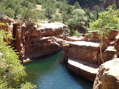
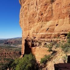
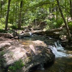
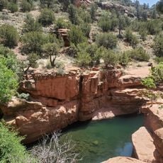
Wet Beaver Wilderness is a protected area in Coconino National Forest in Arizona, carved by deep canyons with reddish sandstone walls and layered shale. A creek runs through the gorge all year long, threading a strip of green through an otherwise dry and open desert landscape.

Congress designated this area as wilderness in 1984 under the Arizona Wilderness Act, one of several protections passed that year for land across the state. The designation locked in protection for the canyon and its creek, preventing any future construction or development inside the boundaries.

The name "Wet Beaver" refers to the creek running through the area and sets it apart from the nearby Dry Beaver Wilderness. Visitors walking along the trail quickly notice how the water draws dense plant growth that looks and feels completely different from the dry land surrounding it.

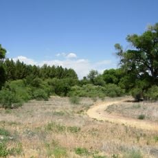
The main trail follows the creek valley and involves crossing the water multiple times, so sturdy footwear is a good idea. Spring and fall tend to offer the most comfortable conditions, as summer heat in the canyon can be intense.

Although the creek flows all year, its water level can change a great deal depending on recent rainfall, making some crossings difficult or impossible after heavy rain. Checking current conditions before heading out can make a real difference in how far into the canyon a visitor can go.

The community of curious travelers

AroundUs brings together thousands of curated places, local tips, and hidden gems, enriched daily by 60,000 contributors worldwide.

Start exploring
Location
GPS coordinates
34.32000,-111.65000
Latest update
March 3, 2026 10:10
Around this place
Cathedral Rock
United States of America

Cathedral Rock

57.2 km
Red Rock State Park
United States of America

Red Rock State Park

57.4 km
Tonto Natural Bridge
United States of America

Tonto Natural Bridge

17.7 km
Bell Rock
United States of America

Bell Rock

54.5 km
Blue Ridge Reservoir
United States of America

Blue Ridge Reservoir

47.5 km
Dead Horse Ranch State Park
United States of America

Dead Horse Ranch State Park

58.5 km
Out of Africa Wildlife Park
United States of America

Out of Africa Wildlife Park

41.1 km
Discovery Channel Telescope
United States of America

Discovery Channel Telescope

51.7 km
Fort Verde State Historic Park
United States of America

Fort Verde State Historic Park

33 km
Childs-Irving Hydroelectric Facilities
United States of America

Childs-Irving Hydroelectric Facilities

5.6 km
Courthouse Butte
United States of America

Courthouse Butte

54.4 km
V-Bar-V Heritage Site
United States of America

V-Bar-V Heritage Site

38.5 km
Mayer Red Brick Schoolhouse
United States of America

Mayer Red Brick Schoolhouse

54.9 km
Fossil Springs Wilderness
United States of America

Fossil Springs Wilderness

17.4 km
Verde River Sheep Bridge
United States of America

Verde River Sheep Bridge

27.5 km
Cathedral Rock Trailhead
United States of America

Cathedral Rock Trailhead

57.7 km
Tonto Natural Bridge State Park
United States of America

Tonto Natural Bridge State Park

17.8 km
Fossil Creek Bridge
United States of America

Fossil Creek Bridge

8.5 km
Beaver Creek Ranger Station
United States of America

Beaver Creek Ranger Station

39.7 km
Strawberry Schoolhouse
United States of America

Strawberry Schoolhouse

15.4 km
Clear Creek Church
United States of America

Clear Creek Church

28.1 km
Copper Creek Guard Station
United States of America

Copper Creek Guard Station

32.4 km
Master Mechanic's House
United States of America

Master Mechanic's House

57.5 km
Horton Creek Trail #285
United States of America

Horton Creek Trail #285

52.7 km
Bell Trail
United States of America

Bell Trail

39.9 km
Verde Valley Archaeology Center and Museum
United States of America

Verde Valley Archaeology Center and Museum

33.6 km
Moqui Lookout
United States of America

Moqui Lookout

51.9 km
Apache Maid Lookout
United States of America

Apache Maid Lookout

46 km
Show the full map
Reviews
Share your experience

No review yet

Discussions
Start a discussion...

No discussion yet

« Wet Beaver Wilderness - Protected wilderness area in Coconino National Forest, Arizona » is provided by Around Us (aroundus.com). Images and texts are derived from Wikimedia project under a Creative Commons license. You are allowed to copy, distribute, and modify copies of this page, under the conditions set by the license, as long as this note is clearly visible.

Discover hidden gems everywhere you go!

From secret cafés to breathtaking viewpoints, skip the crowded tourist spots and find places that match your style. Our app makes it easy with voice search, smart filtering, route optimization, and insider tips from travelers worldwide. Download now for the complete mobile experience.

Around Us App Screenshot

A unique approach to discovering new places

Le Figaro

All the places worth exploring

France Info

A tailor-made excursion in just a few clicks

20 Minutes

Around Us
Travel Guide & Maps
Download

Send to your phone

QR Code
1

Open the camera app on your mobile.

2

Point at the QR code with your camera. A notification will appear.

3

Tap the notification to open the link.