Enable Location

We need your location to show you interesting places around you

Discover nearby places

Find interesting locations and hidden gems around you

Precise directions

Get accurate directions and distances to places

Your location is never shared with other users. It's only used when you tap the location button.

Blue Ridge Reservoir

Log in to your account

Start exploring — it's free

Trusted by 64,892 travelers worldwide

Continue with Google
Continue with Apple
or

We will send you a code to connect

By continuing, you accept our Terms and Conditions and our Privacy Policy

Check your inbox

We've sent a pincode in your inbox. Please enter the code below.

Blue Ridge Reservoir
Discussion Reviews 1 Photos
8.3k Popularity

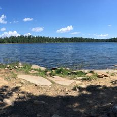
Blue Ridge Reservoir, reservoir in Arizona

Blue Ridge Reservoir is a man-made lake in Coconino County, northern Arizona, formed by damming East Clear Creek. It sits at roughly 6,600 feet (about 2,000 m) in elevation, surrounded by pine forest that stays green through most of the year.

The reservoir was created in the mid-20th century as part of water planning for the northern Arizona region. Building the dam permanently changed the course of East Clear Creek and turned the valley into a standing body of water.

The area is used for fishing, boating, and camping, with nearby campgrounds giving direct access to the water. Because the area can receive heavy snow in winter, a visit from late spring through fall tends to work best.

Although it sits on the Arizona high plateau, the landscape around the reservoir looks more like the Rocky Mountains than the desert scenery most people associate with the state. First-time visitors are often caught off guard by how dense and cool the surrounding forest feels.

The community of curious travelers

AroundUs brings together thousands of curated places, local tips, and hidden gems, enriched daily by 60,000 contributors worldwide.

Start exploring
Location
GPS coordinates
34.53831,-111.20542
Latest update
March 3, 2026 08:20
Around this place
Meteor Crater
United States of America

Meteor Crater

57 km
Cathedral Rock
United States of America

Cathedral Rock

62.3 km
Canyon Diablo meteorite
United States of America

Canyon Diablo meteorite

59.1 km
Tonto Natural Bridge
United States of America

Tonto Natural Bridge

33.6 km
Meteor Crater Natural Landmark
United States of America

Meteor Crater Natural Landmark

57 km
Bell Rock
United States of America

Bell Rock

59 km
Willow Springs Lake
United States of America

Willow Springs Lake

40.3 km
Discovery Channel Telescope
United States of America

Discovery Channel Telescope

30.3 km
Wet Beaver Wilderness
United States of America

Wet Beaver Wilderness

47.5 km
Fort Verde State Historic Park
United States of America

Fort Verde State Historic Park

59.4 km
Meteor Crater Visitor Center
United States of America

Meteor Crater Visitor Center

57.6 km
Childs-Irving Hydroelectric Facilities
United States of America

Childs-Irving Hydroelectric Facilities

50 km
Courthouse Butte
United States of America

Courthouse Butte

58.2 km
V-Bar-V Heritage Site
United States of America

V-Bar-V Heritage Site

49 km
Fossil Springs Wilderness
United States of America

Fossil Springs Wilderness

32.5 km
Cathedral Rock Trailhead
United States of America

Cathedral Rock Trailhead

62.2 km
Tonto Natural Bridge State Park
United States of America

Tonto Natural Bridge State Park

33.5 km
Fossil Creek Bridge
United States of America

Fossil Creek Bridge

42.1 km
Beaver Creek Ranger Station
United States of America

Beaver Creek Ranger Station

48.7 km
Strawberry Schoolhouse
United States of America

Strawberry Schoolhouse

32.3 km
Clear Creek Church
United States of America

Clear Creek Church

57.1 km
Pleasant Valley Ranger Station
United States of America

Pleasant Valley Ranger Station

53.1 km
Horton Creek Trail #285
United States of America

Horton Creek Trail #285

23.5 km
Bell Trail
United States of America

Bell Trail

48.9 km
Verde Valley Archaeology Center and Museum
United States of America

Verde Valley Archaeology Center and Museum

60.3 km
American Astronaut Wall of Fame
United States of America

American Astronaut Wall of Fame

57.6 km
Midgley Bridge
United States of America

Midgley Bridge

62.5 km
Moqui Lookout
United States of America

Moqui Lookout

4.5 km
Show the full map
Reviews
Share your experience

No review yet

Discussions
Start a discussion...

No discussion yet

« Blue Ridge Reservoir - reservoir in Arizona » is provided by Around Us (aroundus.com). Images and texts are derived from Wikimedia project under a Creative Commons license. You are allowed to copy, distribute, and modify copies of this page, under the conditions set by the license, as long as this note is clearly visible.

Discover hidden gems everywhere you go!

From secret cafés to breathtaking viewpoints, skip the crowded tourist spots and find places that match your style. Our app makes it easy with voice search, smart filtering, route optimization, and insider tips from travelers worldwide. Download now for the complete mobile experience.

Around Us App Screenshot

A unique approach to discovering new places

Le Figaro

All the places worth exploring

France Info

A tailor-made excursion in just a few clicks

20 Minutes

Around Us
Travel Guide & Maps
Download

Send to your phone

QR Code
1

Open the camera app on your mobile.

2

Point at the QR code with your camera. A notification will appear.

3

Tap the notification to open the link.