Enable Location

We need your location to show you interesting places around you

Discover nearby places

Find interesting locations and hidden gems around you

Precise directions

Get accurate directions and distances to places

Your location is never shared with other users. It's only used when you tap the location button.

Mesilla Plaza

Log in to your account

Start exploring — it's free

Trusted by 62,535 travelers worldwide

Continue with Google
Continue with Apple
or

We will send you a code to connect

By continuing, you accept our Terms and Conditions and our Privacy Policy

Check your inbox

We've sent a pincode in your inbox. Please enter the code below.

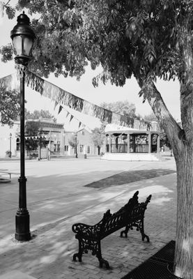
Mesilla Plaza, Historic plaza in Mesilla, New Mexico, US

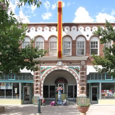
Mesilla Plaza is a historic square in southern New Mexico surrounded by territorial-style buildings from the 1850s that line its edges. The plaza itself features brick sidewalks, open grassy areas, and a bandstand at its center.

Mexican residents founded Mesilla following the Treaty of Guadalupe Hidalgo in 1848 to preserve their culture as northern territories became part of the United States. The settlement grew rapidly into a major trading center and a crucial hub on important travel routes across the region.

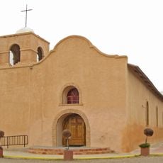
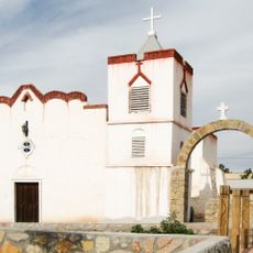
The Basilica of San Albino has stood at the plaza's north end since 1906, displaying its yellow-brick walls and pyramid-topped bell towers as symbols of religious faith held by generations. This space continues to serve as a gathering place where people celebrate local traditions and religious observances throughout the year.

The plaza remains accessible throughout the year and features restaurants, shops, and historic buildings within easy walking distance around its perimeter. Visitors can stroll across the brick-paved surface and explore the various structures that frame this central space.

By the late 1860s, Mesilla had become the largest settlement between San Antonio and San Diego, serving as a major stop on the Butterfield Overland Mail route. This strategic position made it an essential hub for trade and communication across the frontier at that time.

The community of curious travelers

AroundUs brings together thousands of curated places, local tips, and hidden gems, enriched daily by 60,000 contributors worldwide.

Start exploring
Location
Inception
1848
GPS coordinates
32.27431,-106.79546
Latest update
December 12, 2025 17:44
Around this place
Aggie Memorial Stadium
United States of America

Aggie Memorial Stadium

5.2 km
Prehistoric Trackways National Monument
United States of America

Prehistoric Trackways National Monument

14.5 km
Fort Selden
United States of America

Fort Selden

26.1 km
Organ Needle
United States of America

Organ Needle

23.4 km
San Augustin Mountains
United States of America

San Augustin Mountains

27.6 km
Rio Grande Theatre
United States of America

Rio Grande Theatre

4.4 km
Mesilla Valley Bosque State Park
United States of America

Mesilla Valley Bosque State Park

6.4 km
Cathedral of the Immaculate Heart of Mary
United States of America

Cathedral of the Immaculate Heart of Mary

3.9 km
Thomas Branigan Memorial Library
United States of America

Thomas Branigan Memorial Library

4.9 km
Wells Fargo Tower
United States of America

Wells Fargo Tower

3.8 km
San Jose Church
United States of America

San Jose Church

18.9 km
Green Bridge
United States of America

Green Bridge

7.6 km
Goddard Hall
United States of America

Goddard Hall

4 km
Alameda-Depot Historic District
United States of America

Alameda-Depot Historic District

4.4 km
Phillips Chapel CME Church
United States of America

Phillips Chapel CME Church

5 km
Chope's Town Cafe and Bar
United States of America

Chope's Town Cafe and Bar

19.2 km
Foster Hall
United States of America

Foster Hall

4.1 km
Rio Grande Bridge at Radium Springs
United States of America

Rio Grande Bridge at Radium Springs

26.6 km
L.B. Bentley General Merchandise
United States of America

L.B. Bentley General Merchandise

25.2 km
Nason House
United States of America

Nason House

4 km
Barela-Reynolds House
United States of America

Barela-Reynolds House

24 m
Frank and Amelia Jones House
United States of America

Frank and Amelia Jones House

16.2 km
Hadley-Ludwick House
United States of America

Hadley-Ludwick House

3.3 km
Nestor Armijo House
United States of America

Nestor Armijo House

3.9 km
Dona Ana Village Historic District
United States of America

Dona Ana Village Historic District

12.8 km
Mesilla Park Historic District
United States of America

Mesilla Park Historic District

2.3 km
Old Doña Ana County Courthouse
United States of America

Old Doña Ana County Courthouse

3.9 km
Branigan Cultural Center
United States of America

Branigan Cultural Center

4.6 km
Show the full map
« Mesilla Plaza - Historic plaza in Mesilla, New Mexico, US » is provided by Around Us (aroundus.com). Images and texts are derived from Wikimedia project under a Creative Commons license. You are allowed to copy, distribute, and modify copies of this page, under the conditions set by the license, as long as this note is clearly visible.

Discover hidden gems everywhere you go!

From secret cafés to breathtaking viewpoints, skip the crowded tourist spots and find places that match your style. Our app makes it easy with voice search, smart filtering, route optimization, and insider tips from travelers worldwide. Download now for the complete mobile experience.

Around Us App Screenshot

A unique approach to discovering new places

Le Figaro

All the places worth exploring

France Info

A tailor-made excursion in just a few clicks

20 Minutes

Around Us
Travel Guide & Maps
Download

Send to your phone

QR Code
1

Open the camera app on your mobile.

2

Point at the QR code with your camera. A notification will appear.

3

Tap the notification to open the link.