Enable Location

We need your location to show you interesting places around you

Discover nearby places

Find interesting locations and hidden gems around you

Precise directions

Get accurate directions and distances to places

Your location is never shared with other users. It's only used when you tap the location button.

Log in to your account

Start exploring — it's free

Trusted by 62,535 travelers worldwide

Continue with Google
Continue with Apple
or

We will send you a code to connect

By continuing, you accept our Terms and Conditions and our Privacy Policy

Check your inbox

We've sent a pincode in your inbox. Please enter the code below.

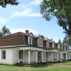
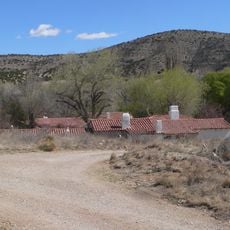
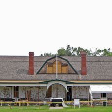
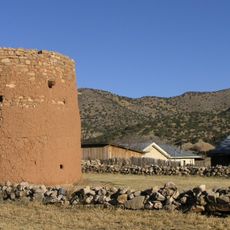
Flying H Ranch, Historic ranch near Roswell, New Mexico.

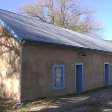
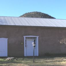
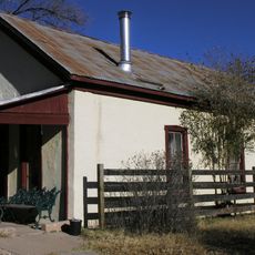
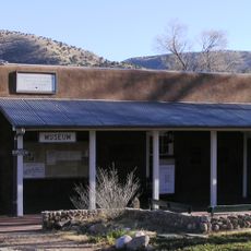
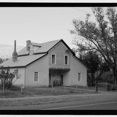
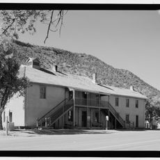
Flying H Ranch is a historic ranching property near Roswell with ten buildings arranged across separate areas. The structures feature traditional New Mexico building methods using adobe and wood, representing how working ranches were constructed and organized.

The ranch developed in the 1890s as a working property that helped shape early ranching in the region. It was listed on the National Register in 1988 to preserve its importance as a record of how ranchers lived and operated during that time.

The buildings show how early ranchers lived and worked in the New Mexico territory. Adobe and wood structures display the practical ways people constructed their homes and work spaces.

The property sits near U.S. Route 70 between Hope and Elk Area, making it accessible from the main road. Visitors can view the buildings and walk around the grounds to observe how the structures are positioned and what each served during its working years.

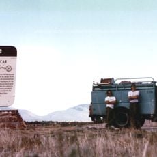
Billy the Kid spent time at this ranch and used a dugout shelter on the property as a hideout during his years in the territory. This connection to the outlaw adds another layer of interest for those fascinated by Old West history.

The community of curious travelers

AroundUs brings together thousands of curated places, local tips, and hidden gems, enriched daily by 60,000 contributors worldwide.

Start exploring
Location
GPS coordinates
33.01139,-105.13944
Latest update
December 14, 2025 18:03
Around this place
Fort Stanton
United States of America

Fort Stanton

64.7 km
National Solar Observatory
United States of America

National Solar Observatory

68.3 km
Dunn Solar Telescope
United States of America

Dunn Solar Telescope

68.4 km
Mexican Canyon Trestle
United States of America

Mexican Canyon Trestle

57 km
NASA Orbital Debris Observatory
United States of America

NASA Orbital Debris Observatory

55.6 km
Fox Cave
United States of America

Fox Cave

53.7 km
Lincoln Historic District
United States of America

Lincoln Historic District

58.4 km
Cloudcroft Observatory
United States of America

Cloudcroft Observatory

55.6 km
Fort Stanton – Snowy River Cave National Conservation Area
United States of America

Fort Stanton – Snowy River Cave National Conservation Area

61.6 km
Peter and Henriette Wyeth Hurd House
United States of America

Peter and Henriette Wyeth Hurd House

47.1 km
Wofford Lookout Complex
United States of America

Wofford Lookout Complex

53.4 km
Old Dowlin Mill
United States of America

Old Dowlin Mill

58.7 km
Weed Lookout Tower
United States of America

Weed Lookout Tower

45.5 km
Fort Stanton Museum
United States of America

Fort Stanton Museum

64.7 km
Ruidoso Public Library
United States of America

Ruidoso Public Library

61.5 km
Walker Aviation Museum
United States of America

Walker Aviation Museum

66.5 km
Spencer Theater for the Performing Arts
United States of America

Spencer Theater for the Performing Arts

63.9 km
Tunstall Store
United States of America

Tunstall Store

58.3 km
Fort Stanton Hospital Administration Building
United States of America

Fort Stanton Hospital Administration Building

64.7 km
Smokey Bear Vista Point
United States of America

Smokey Bear Vista Point

67.8 km
Montano Store
United States of America

Montano Store

58.1 km
Convento
United States of America

Convento

58.2 km
Curry Saloon
United States of America

Curry Saloon

58.5 km
Anderson-Freeman Museum and Visitors Center
United States of America

Anderson-Freeman Museum and Visitors Center

58.2 km
Dr. Woods House
United States of America

Dr. Woods House

58.4 km
Old Lincoln County Courthouse
United States of America

Old Lincoln County Courthouse

58.6 km
Torreon
United States of America

Torreon

58.3 km
Sunspot Solar System Model
United States of America

Sunspot Solar System Model

61.6 km
Show the full map
« Flying H Ranch - Historic ranch near Roswell, New Mexico » is provided by Around Us (aroundus.com). Images and texts are derived from Wikimedia project under a Creative Commons license. You are allowed to copy, distribute, and modify copies of this page, under the conditions set by the license, as long as this note is clearly visible.

Discover hidden gems everywhere you go!

From secret cafés to breathtaking viewpoints, skip the crowded tourist spots and find places that match your style. Our app makes it easy with voice search, smart filtering, route optimization, and insider tips from travelers worldwide. Download now for the complete mobile experience.

Around Us App Screenshot

A unique approach to discovering new places

Le Figaro

All the places worth exploring

France Info

A tailor-made excursion in just a few clicks

20 Minutes

Around Us
Travel Guide & Maps
Download

Send to your phone

QR Code
1

Open the camera app on your mobile.

2

Point at the QR code with your camera. A notification will appear.

3

Tap the notification to open the link.