Enable Location

We need your location to show you interesting places around you

Discover nearby places

Find interesting locations and hidden gems around you

Precise directions

Get accurate directions and distances to places

Your location is never shared with other users. It's only used when you tap the location button.

Alajuela Canton

Log in to your account

Start exploring — it's free

Trusted by 63,646 travelers worldwide

Continue with Google
Continue with Apple
or

We will send you a code to connect

By continuing, you accept our Terms and Conditions and our Privacy Policy

Check your inbox

We've sent a pincode in your inbox. Please enter the code below.

Discussion Reviews 1 Photos
26.9k Popularity

Alajuela Canton, Administrative district in Central Valley, Costa Rica

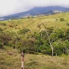
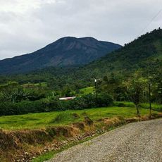
Alajuela Canton is an administrative region in Costa Rica's Central Valley, spanning hilly terrain between two major volcanoes. The territory includes fourteen districts organized within the broader Alajuela Province.

The region became an official canton in 1848, receiving its present administrative structure through provincial decree. This establishment reflected broader governmental efforts to organize the province into separate district units.

Coffee farming shapes daily life across this region, where plantations dot the landscape and connect families to generations of agricultural tradition. These working lands form the social and economic center of many local communities.

This region sits conveniently on major transportation corridors, making it readily accessible from surrounding areas. The hilly terrain affects travel times between different parts of the canton.

The region is home to several significant coffee farms, including operations that have supplied beans to international markets for decades. These long-standing agricultural enterprises anchor the canton's economic identity.

The community of curious travelers

AroundUs brings together thousands of curated places, local tips, and hidden gems, enriched daily by 60,000 contributors worldwide.

Start exploring
Capital city
Alajuela
Elevation above the sea
942 m
Shares border with
Heredia Canton, Santa Bárbara Canton, Belén Canton, Santa Ana Canton, Mora Canton, Atenas Canton, Grecia Canton, Poás Canton, Sarchí Canton, Sarapiquí Canton, Flores Canton
GPS coordinates
10.16500,-84.26639
Latest update
December 20, 2025 14:26
Reviews
Share your experience

No review yet

Discussions
Start a discussion...

No discussion yet

« Alajuela Canton - Administrative district in Central Valley, Costa Rica » is provided by Around Us (aroundus.com). Images and texts are derived from Wikimedia project under a Creative Commons license. You are allowed to copy, distribute, and modify copies of this page, under the conditions set by the license, as long as this note is clearly visible.

Discover hidden gems everywhere you go!

From secret cafés to breathtaking viewpoints, skip the crowded tourist spots and find places that match your style. Our app makes it easy with voice search, smart filtering, route optimization, and insider tips from travelers worldwide. Download now for the complete mobile experience.

Around Us App Screenshot

A unique approach to discovering new places

Le Figaro

All the places worth exploring

France Info

A tailor-made excursion in just a few clicks

20 Minutes

Around Us
Travel Guide & Maps
Download

Send to your phone

QR Code
1

Open the camera app on your mobile.

2

Point at the QR code with your camera. A notification will appear.

3

Tap the notification to open the link.