Citlaltepetl, Stratovolcano in Veracruz and Puebla, Mexico.
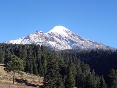
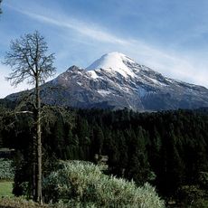
Citlaltepetl is a stratovolcano located across Veracruz and Puebla states in Mexico, reaching 5636 meters (about 18,491 feet) above sea level. Built from layers of andesite, it forms the country's highest point and stands as North America's third tallest peak, distinguished by its conical shape and year-round snow coverage on its upper slopes.
Henri Galeotti led the first recorded European expedition to the summit in 1839, followed by American military personnel who reached the top in 1848 during the Mexican-American War. Indigenous peoples had climbed and honored the mountain for centuries before these documented ascents, using it as a navigational reference between the highlands and the Gulf coast.
Local communities in both Puebla and Veracruz regard the mountain as a sacred landmark, its snowy summit visible from far across the central highlands. Indigenous traditions connect the peak to celestial phenomena, and its presence continues to shape regional identity, appearing in art and storytelling throughout the area.
Climbing conditions are most favorable between October and April, when weather patterns stabilize and the northwestern face provides the most gradual route for ascents. Visitors should allow several days for altitude adjustment, and hiring experienced guides is strongly recommended due to glacier navigation and rapidly changing mountain conditions.
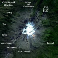
Nine glaciers cling to the upper slopes, with Gran Glaciar Norte being the largest and feeding several outlet streams that shape the surrounding valleys. Despite its location in the tropics, the summit maintains year-round snow through orographic lift, creating a permanent ice cap that contrasts sharply with the warm lowlands below.
The community of curious travelers
AroundUs brings together thousands of curated places, local tips, and hidden gems, enriched daily by 60,000 contributors worldwide.