Chest opened
+${chestReward.xp} XP
Explorer
NOUVEAU ×${chestReward.collectible.quantity}
tapez pour fermer

See the monuments around you in AR Open chests in the app

Around Us is built for your phone — point your camera at the streets and discover the monuments and places around you in augmented reality. Around Us is built for your phone — chests unlock when you walk, explore and capture nearby places.

•

Enable Location

We need your location to show you interesting places around you

Discover nearby places

Find interesting locations and hidden gems around you

Precise directions

Get accurate directions and distances to places

Your location is never shared with other users. It's only used when you tap the location button.

Pico de Orizaba National Park

Log in to your account

Start exploring — it's free

Trusted by 93,779 travelers worldwide

Continue with Google
Continue with Apple
or

We will send you a code to connect

By continuing, you accept our Terms and Conditions and our Privacy Policy

Check your inbox

We've sent a pincode in your inbox. Please enter the code below.

Pico de Orizaba National Park, National park with snow-capped volcano in Puebla and Veracruz, Mexico

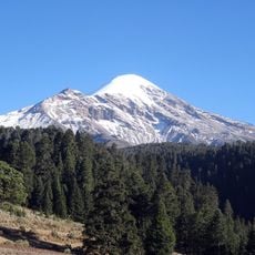
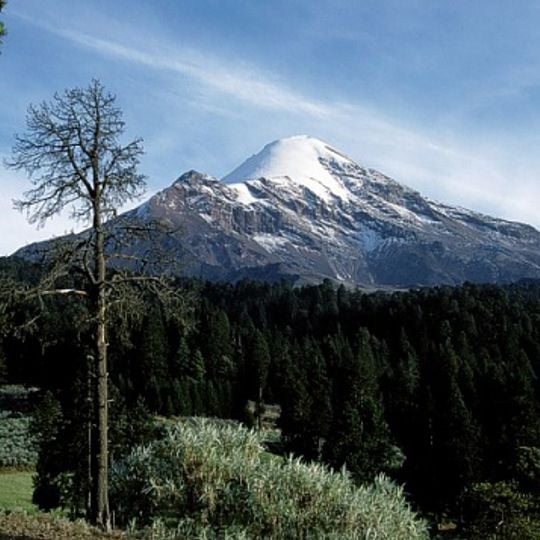
Pico de Orizaba National Park covers 197.5 square kilometers across Puebla and Veracruz. Its volcano, the country's highest peak, rises from a grassland zone at 4,000 meters to a summit at 5,651 meters, where perpetual snow and glaciers cover the top. Below the snowline, bare gray and brown rock is cut by dark ridges and gullies, with bands of snow running down the upper slopes above forested land.

The park was created on January 4, 1937, covering 197.5 square kilometers across Puebla and Veracruz. The volcano itself formed from a violent Strombolian eruption several million years ago, on a high fold of the Sierra Madre Oriental about 3,000 meters up, which let it reach one of the greatest heights of any volcano. Eruptions were recorded during the colonial period, mainly in the 17th century.

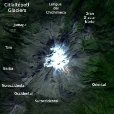
The Nahuatl name Citlaltépetl, Star Mountain, refers to the snow-covered cone. The park lies in the Sierra Madre Oriental within the Eje Neovolcánico, and its glaciers feed the Jamapa, Metlac and Orizaba rivers; the Jamapa rises from the glacier of the same name. Above 4,000 m the cold and perpetual snow stop all vegetation, leaving alpine grassland of juniper and Cirsium nivale below the ice.

Several hiking trails and climbing routes pass through the area, with most visitors arriving via Calcahualco. Camping sites are available, and conditions change significantly with altitude.

The largest glacier in Mexico sits here and measures between 20 and 50 meters (65 to 165 feet) thick. Scientists expect the ice to disappear completely in the coming years.

The community of curious travelers

AroundUs brings together thousands of curated places, local tips, and hidden gems, enriched daily by 93,779 contributors worldwide.


Start exploring
Location
Location
Inception
January 4, 1937
GPS coordinates
19.05209,-97.26874
Latest update
November 3, 2026 21:40
Reviews
Share your experience

No review yet

Discussions
Start a discussion...

No discussion yet

« Pico de Orizaba National Park - National park with snow-capped volcano in Puebla and Veracruz, Mexico » is provided by Around Us (aroundus.com). Images and texts are derived from Wikimedia project under a Creative Commons license. You are allowed to copy, distribute, and modify copies of this page, under the conditions set by the license, as long as this note is clearly visible.

Discover hidden gems everywhere you go!

From secret cafés to breathtaking viewpoints, skip the crowded tourist spots and find places that match your style. Our app makes it easy with voice search, smart filtering, route optimization, and insider tips from travelers worldwide. Download now for the complete mobile experience.

Around Us App Screenshot
❝

A unique approach to discovering new places❞

— Le Figaro

❝

All the places worth exploring❞

— France Info

❝

A tailor-made excursion in just a few clicks❞

— 20 Minutes

Around Us
Travel Guide & Maps
Download

Send to your phone

QR Code
1

Open the camera app on your mobile.

2

Point at the QR code with your camera. A notification will appear.

3

Tap the notification to open the link.