Enable Location

We need your location to show you interesting places around you

Discover nearby places

Find interesting locations and hidden gems around you

Precise directions

Get accurate directions and distances to places

Your location is never shared with other users. It's only used when you tap the location button.

Fort Travis

Log in to your account

Start exploring — it's free

Trusted by 61,947 travelers worldwide

Continue with Google
Continue with Apple
or

We will send you a code to connect

By continuing, you accept our Terms and Conditions and our Privacy Policy

Check your inbox

We've sent a pincode in your inbox. Please enter the code below.

Fort Travis, Military fort in Port Bolivar, United States

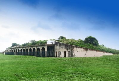
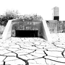
Fort Travis is a historic coastal fort in Port Bolivar with concrete bunkers, gun batteries, and a 17-foot seawall facing the Gulf of Mexico. The installation covers 60 acres of coastal land and shows how a military defense position was built and arranged during the early 1900s.

The federal government built Fort Travis in 1898 to protect Galveston Harbor and constructed four gun batteries as a coastal defense line. The fort served an important role during both world wars and demonstrates how American coastal defense grew during that era.

The name honors William B. Travis, a Texas military leader from the independence era. You can see how soldiers worked and lived in this coastal defense position.

The site is accessible for walking exploration, with picnic areas and cooking facilities spread throughout. You can watch ships passing through Bolivar Roads toward Houston while taking in the coastal views.

During World War II, the installation housed approximately 2,500 troops and housed heavy gun systems positioned to defend the gulf approaches. The scale of this military presence demonstrates how critical this location was to regional defense during the war.

The community of curious travelers

AroundUs brings together thousands of curated places, local tips, and hidden gems, enriched daily by 60,000 contributors worldwide.

Start exploring
Location
Address
St Hwy 87 at Loop 108
GPS coordinates
29.36512,-94.75800
Latest update
December 10, 2025 20:10
Around this place
Bishop's Palace
United States of America

Bishop's Palace

7.3 km
Galveston Seawall
United States of America

Galveston Seawall

7.2 km
Elissa
United States of America

Elissa

7.1 km
USS Stewart
United States of America

USS Stewart

3.9 km
Seawolf Park
United States of America

Seawolf Park

3.8 km
Strand Historic District
United States of America

Strand Historic District

7.4 km
Bolivar Bridge
United States of America

Bolivar Bridge

3 km
Grand 1894 Opera House
United States of America

Grand 1894 Opera House

7.4 km
Point Bolivar Lighthouse
United States of America

Point Bolivar Lighthouse

906 m
One Moody Plaza
United States of America

One Moody Plaza

7.2 km
Ocean Star Offshore Drilling Rig & Museum
United States of America

Ocean Star Offshore Drilling Rig & Museum

7.3 km
East End Historic District
United States of America

East End Historic District

7.2 km
Pink Dolphin Monument
United States of America

Pink Dolphin Monument

4.5 km
George Washington Grover House
United States of America

George Washington Grover House

6.9 km
First Presbyterian Church
United States of America

First Presbyterian Church

7.4 km
Isaac Heffron House
United States of America

Isaac Heffron House

7 km
Galveston Historic Seaport
United States of America

Galveston Historic Seaport

7.1 km
Mathilda Wehmeyer House and German-American Kindergarten School
United States of America

Mathilda Wehmeyer House and German-American Kindergarten School

7.2 km
East Beach
United States of America

East Beach

5.3 km
Illies Building-Justine Apartments
United States of America

Illies Building-Justine Apartments

7.5 km
Campbell Home
United States of America

Campbell Home

7.4 km
Building at 1921-1921 1/2 Avenue D
United States of America

Building at 1921-1921 1/2 Avenue D

7.2 km
Robinson Building
United States of America

Robinson Building

7.4 km
U.S. National Bank
United States of America

U.S. National Bank

7.5 km
Wilbur Cherry House
United States of America

Wilbur Cherry House

7.1 km
Building at 1925-1927 Market Street
United States of America

Building at 1925-1927 Market Street

7.3 km
Isabella Offenbach Maas Residence
United States of America

Isabella Offenbach Maas Residence

7.5 km
Fort San Jacinto
United States of America

Fort San Jacinto

3.2 km
Show the full map
« Fort Travis - Military fort in Port Bolivar, United States » is provided by Around Us (aroundus.com). Images and texts are derived from Wikimedia project under a Creative Commons license. You are allowed to copy, distribute, and modify copies of this page, under the conditions set by the license, as long as this note is clearly visible.

Discover hidden gems everywhere you go!

From secret cafés to breathtaking viewpoints, skip the crowded tourist spots and find places that match your style. Our app makes it easy with voice search, smart filtering, route optimization, and insider tips from travelers worldwide. Download now for the complete mobile experience.

Around Us App Screenshot

A unique approach to discovering new places

Le Figaro

All the places worth exploring

France Info

A tailor-made excursion in just a few clicks

20 Minutes

Around Us
Travel Guide & Maps
Download

Send to your phone

QR Code
1

Open the camera app on your mobile.

2

Point at the QR code with your camera. A notification will appear.

3

Tap the notification to open the link.