Enable Location

We need your location to show you interesting places around you

Discover nearby places

Find interesting locations and hidden gems around you

Precise directions

Get accurate directions and distances to places

Your location is never shared with other users. It's only used when you tap the location button.

McFaddin and Texas Point National Wildlife Refuges

Log in to your account

Start exploring — it's free

Trusted by 65,444 travelers worldwide

Continue with Google
Continue with Apple
or

We will send you a code to connect

By continuing, you accept our Terms and Conditions and our Privacy Policy

Check your inbox

We've sent a pincode in your inbox. Please enter the code below.

McFaddin and Texas Point National Wildlife Refuges
Discussion Reviews 1 Photos
3k Popularity

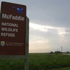
McFaddin and Texas Point National Wildlife Refuges, Wildlife refuges in Jefferson County, US

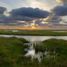
McFaddin and Texas Point National Wildlife Refuges are two adjacent federal protected areas on the Gulf Coast in southeast Texas, near the city of Beaumont. They consist mostly of salt marsh, shallow open water, and brackish ponds that run along the edge of the Gulf of Mexico.

McFaddin was established by the U.S. Fish and Wildlife Service in the late 1970s, and Texas Point followed in the early 1980s. Both refuges were created in response to the sharp decline of waterfowl along the Gulf Coast, and the land was acquired from private ranches and rice farms.

The refuges sit along a major bird migration route known as the Central Flyway, which channels birds between Canada and South America. Birdwatchers come here in fall and winter to spot large flocks of snow geese, teal, and sandpipers moving through the coastal marshes.

A visitor center along State Highway 87, between Baytown and Winnie, is a good starting point before heading into either refuge. Bring insect repellent, waterproof footwear, and plenty of water, as services inside the grounds are minimal and the terrain can be wet year-round.

After Hurricane Rita in 2005, parts of the refuges were heavily damaged by saltwater flooding, and researchers used the recovery as a rare opportunity to study how coastal marshes rebuild themselves. Some sections of the terrain still show signs of that event, with patches of open water where thick marsh once stood.

The community of curious travelers

AroundUs brings together thousands of curated places, local tips, and hidden gems, enriched daily by 60,000 contributors worldwide.

Start exploring
Inception
1980
GPS coordinates
29.66667,-94.15000
Latest update
March 3, 2026 13:52
Around this place
Spindletop
United States of America

Spindletop

39.9 km
Rainbow Bridge
United States of America

Rainbow Bridge

44 km
Ford Arena
United States of America

Ford Arena

38.4 km
Sea Rim State Park
United States of America

Sea Rim State Park

12.6 km
Provost Umphrey Stadium
United States of America

Provost Umphrey Stadium

42.6 km
Ford Park
United States of America

Ford Park

38.3 km
Spindletop-Gladys City Boomtown Museum
United States of America

Spindletop-Gladys City Boomtown Museum

41.3 km
Saint Anthony Cathedral Basilica
United States of America

Saint Anthony Cathedral Basilica

46 km
Sabine Pass Light
United States of America

Sabine Pass Light

29.5 km
Julie Rogers Theater
United States of America

Julie Rogers Theater

46.5 km
Vincent–Beck Stadium
United States of America

Vincent–Beck Stadium

41.6 km
Beaumont Botanical Gardens
United States of America

Beaumont Botanical Gardens

39.7 km
Dishman Art Museum
United States of America

Dishman Art Museum

42.9 km
Tyrrell Historical Library
United States of America

Tyrrell Historical Library

46.5 km
Lamar Soccer Complex
United States of America

Lamar Soccer Complex

41.5 km
Martin Luther King Bridge
United States of America

Martin Luther King Bridge

28.5 km
Mary and John Gray Library
United States of America

Mary and John Gray Library

42.4 km
Idle Hours
United States of America

Idle Hours

45 km
Pompeiian Villa
United States of America

Pompeiian Villa

32.6 km
Rose Hill
United States of America

Rose Hill

33.7 km
Port Arthur Federated Women's Clubhouse
United States of America

Port Arthur Federated Women's Clubhouse

32.5 km
Century Tower
United States of America

Century Tower

46.4 km
Eddingston Court
United States of America

Eddingston Court

34.4 km
Marconi Tower at Port Arthur College
United States of America

Marconi Tower at Port Arthur College

32.1 km
Texas Point National Wildlife Refuge
United States of America

Texas Point National Wildlife Refuge

24.8 km
Gates Memorial Library
United States of America

Gates Memorial Library

31.9 km
Veterans Memorial Bridge
United States of America

Veterans Memorial Bridge

44.2 km
McFaddin National Wildlife Refuge
United States of America

McFaddin National Wildlife Refuge

3.3 km
Show the full map
Reviews
Share your experience

No review yet

Discussions
Start a discussion...

No discussion yet

« McFaddin and Texas Point National Wildlife Refuges - Wildlife refuges in Jefferson County, US » is provided by Around Us (aroundus.com). Images and texts are derived from Wikimedia project under a Creative Commons license. You are allowed to copy, distribute, and modify copies of this page, under the conditions set by the license, as long as this note is clearly visible.

Discover hidden gems everywhere you go!

From secret cafés to breathtaking viewpoints, skip the crowded tourist spots and find places that match your style. Our app makes it easy with voice search, smart filtering, route optimization, and insider tips from travelers worldwide. Download now for the complete mobile experience.

Around Us App Screenshot

A unique approach to discovering new places

Le Figaro

All the places worth exploring

France Info

A tailor-made excursion in just a few clicks

20 Minutes

Around Us
Travel Guide & Maps
Download

Send to your phone

QR Code
1

Open the camera app on your mobile.

2

Point at the QR code with your camera. A notification will appear.

3

Tap the notification to open the link.