Enable Location

We need your location to show you interesting places around you

Discover nearby places

Find interesting locations and hidden gems around you

Precise directions

Get accurate directions and distances to places

Your location is never shared with other users. It's only used when you tap the location button.

Log in to your account

Start exploring — it's free

Trusted by 63,283 travelers worldwide

Continue with Google
Continue with Apple
or

We will send you a code to connect

By continuing, you accept our Terms and Conditions and our Privacy Policy

Check your inbox

We've sent a pincode in your inbox. Please enter the code below.

Pointe-aux-Chenes Wildlife Management Area
Discussion Reviews Photo
1.3k Popularity

Pointe-aux-Chenes Wildlife Management Area, Wetland conservation area in Terrebonne Parish, Louisiana, US.

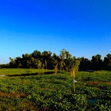
Pointe-aux-Chenes Wildlife Management Area is a wetland containing brackish and freshwater marshes, ponds, bayous, and canals in the southeastern coastal region of Louisiana. The landscape features numerous waterways and swampy terrain that create varied habitats for wildlife.

The area was established to preserve wetlands in a changing coastal region. Water control structures such as weirs and levees were built to manage the ecosystem and protect it from flooding.

The area allows visitors to experience how Louisiana communities live with and depend on coastal marshes for hunting, fishing, and nature observation. Local activities here connect people to their natural environment in a way that shapes daily life.

Access is available through multiple entry points along US Highway 665, with separate zones designated for paddling activities. Visitors should prepare for wet, marshy terrain and changing water levels.

The area consists of three separate management units, each supporting different types of marshes and animal populations. This division allows for more specialized protection and management strategies for each section.

The community of curious travelers

AroundUs brings together thousands of curated places, local tips, and hidden gems, enriched daily by 60,000 contributors worldwide.

Start exploring
GPS coordinates
29.41667,-90.45000
Latest update
December 14, 2025 18:14
Around this place
Laurel Valley Sugar Plantation
United States of America

Laurel Valley Sugar Plantation

53.4 km
Fort Livingston
United States of America

Fort Livingston

51.5 km
Grand Isle State Park
United States of America

Grand Isle State Park

51.2 km
Ardoyne Plantation House
United States of America

Ardoyne Plantation House

44.2 km
Ducros Plantation
United States of America

Ducros Plantation

51.8 km
Edward Douglass White House
United States of America

Edward Douglass White House

46.3 km
Cathedral of St. Francis de Sales
United States of America

Cathedral of St. Francis de Sales

33.1 km
Mandalay National Wildlife Refuge
United States of America

Mandalay National Wildlife Refuge

36.4 km
St. George Plantation House
United States of America

St. George Plantation House

49.9 km
Chatchie Plantation House
United States of America

Chatchie Plantation House

50.3 km
Orange Grove Plantation House
United States of America

Orange Grove Plantation House

40.9 km
Residence Plantation House
United States of America

Residence Plantation House

30.7 km
Bayou Boeuf Elementary School
United States of America

Bayou Boeuf Elementary School

52.3 km
St. Matthew's Episcopal Church
United States of America

St. Matthew's Episcopal Church

32.8 km
Bouverans Plantation House
United States of America

Bouverans Plantation House

24.5 km
Lefort House
United States of America

Lefort House

49.4 km
Armitage
United States of America

Armitage

52.5 km
Argyle
United States of America

Argyle

34 km
Clifford Percival Smith House
United States of America

Clifford Percival Smith House

33.1 km
Creole Lanes
United States of America

Creole Lanes

35.1 km
Merchants and Planters Bank
United States of America

Merchants and Planters Bank

27.1 km
Zephirin Toups Sr. House
United States of America

Zephirin Toups Sr. House

46.2 km
Bank of Lockport
United States of America

Bank of Lockport

27 km
Bayou Terrebonne Waterlife Museum
United States of America

Bayou Terrebonne Waterlife Museum

33.1 km
Manila Village
United States of America

Manila Village

47.3 km
Chauvin Sculpture Garden & Art
United States of America

Chauvin Sculpture Garden & Art

14.2 km
Park Theatre
United States of America

Park Theatre

33.1 km
Barataria Preserve
United States of America

Barataria Preserve

53 km
Show the full map
Reviews
Share your experience

No review yet

Discussions
Start a discussion...

No discussion yet

« Pointe-aux-Chenes Wildlife Management Area - Wetland conservation area in Terrebonne Parish, Louisiana, US » is provided by Around Us (aroundus.com). Images and texts are derived from Wikimedia project under a Creative Commons license. You are allowed to copy, distribute, and modify copies of this page, under the conditions set by the license, as long as this note is clearly visible.

Discover hidden gems everywhere you go!

From secret cafés to breathtaking viewpoints, skip the crowded tourist spots and find places that match your style. Our app makes it easy with voice search, smart filtering, route optimization, and insider tips from travelers worldwide. Download now for the complete mobile experience.

Around Us App Screenshot

A unique approach to discovering new places

Le Figaro

All the places worth exploring

France Info

A tailor-made excursion in just a few clicks

20 Minutes

Around Us
Travel Guide & Maps
Download

Send to your phone

QR Code
1

Open the camera app on your mobile.

2

Point at the QR code with your camera. A notification will appear.

3

Tap the notification to open the link.