Chest opened
+${chestReward.xp} XP
Explorer
NOUVEAU ×${chestReward.collectible.quantity}
tapez pour fermer
Chest locked

Open chests in the app

Around Us is built for your phone — chests unlock when you walk, explore and capture nearby places.

Enable Location

We need your location to show you interesting places around you

Discover nearby places

Find interesting locations and hidden gems around you

Precise directions

Get accurate directions and distances to places

Your location is never shared with other users. It's only used when you tap the location button.

Log in to your account

Start exploring — it's free

Trusted by 72,884 travelers worldwide

Continue with Google
Continue with Apple
or

We will send you a code to connect

By continuing, you accept our Terms and Conditions and our Privacy Policy

Check your inbox

We've sent a pincode in your inbox. Please enter the code below.

Cote Blanche
Discussion Reviews Photo
1.9k Popularity

Cote Blanche, Salt mining hill in St. Mary Parish, Louisiana, United States

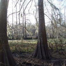
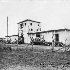
Côte Blanche is a salt mining hill in St. Mary Parish that rises about 25 meters above the surrounding coastal marshes, forming a distinct geological structure. The site operates as an active mining facility where salt deposits are extracted from deep underground.

This salt deposit formed millions of years ago when an ancient saltwater ocean evaporated and left salt layers on the sea floor. Through geological processes and pressure changes over long periods, these salt deposits were pushed upward to form the landform visible today.

French settlers named this area White Coast because of the light coloring visible on the geological formation. The pale appearance that inspired the name remains one of the most noticeable features when visiting.

This is an active mining operation where salt extraction happens continuously, so it functions as a working industrial site. Visitors should understand this is a private mining facility with security restrictions rather than a public recreation area.

This salt mine supplies a major portion of the deicing salt used across North America, particularly for winter road maintenance. The salt is transported via river networks to regions far from the mine.

The community of curious travelers

AroundUs brings together thousands of curated places, local tips, and hidden gems, enriched daily by 60,000 contributors worldwide.

Start exploring
Location
GPS coordinates
29.75360,-91.71580
Latest update
December 14, 2025 11:25
Around this place
Shadows-on-the-Teche
United States of America

Shadows-on-the-Teche

29.5 km
Jungle Gardens
United States of America

Jungle Gardens

25.6 km
Cypremort Point State Park
United States of America

Cypremort Point State Park

13.4 km
Albania Plantation House
United States of America

Albania Plantation House

17.9 km
Lake Fausse Pointe State Park
United States of America

Lake Fausse Pointe State Park

35.6 km
Conrad Rice Mill
United States of America

Conrad Rice Mill

28.7 km
Arlington Plantation House
United States of America

Arlington Plantation House

21.7 km
Oaklawn Manor
United States of America

Oaklawn Manor

26.3 km
Joseph Jefferson House
United States of America

Joseph Jefferson House

35.1 km
St. Martin of Tours Catholic Church
United States of America

St. Martin of Tours Catholic Church

42.5 km
Darby Plantation
United States of America

Darby Plantation

32.9 km
Alice C Plantation House
United States of America

Alice C Plantation House

23.1 km
Calumet Plantation House
United States of America

Calumet Plantation House

36.2 km
Steamboat House
United States of America

Steamboat House

28.8 km
Downtown New Iberia Commercial Historic District
United States of America

Downtown New Iberia Commercial Historic District

29.9 km
Episcopal Church of the Epiphany
United States of America

Episcopal Church of the Epiphany

30.1 km
St. Mary's Episcopal Church
United States of America

St. Mary's Episcopal Church

17.2 km
New Iberia High School
United States of America

New Iberia High School

29.2 km
Louisiana State Museum – Patterson
United States of America

Louisiana State Museum – Patterson

41.6 km
East Main Street Historic District
United States of America

East Main Street Historic District

29.1 km
The Magnolias
United States of America

The Magnolias

30.1 km
First United Methodist Church
United States of America

First United Methodist Church

30.1 km
Grevemberg House
United States of America

Grevemberg House

21.8 km
St. Martin Parish Courthouse
United States of America

St. Martin Parish Courthouse

42.2 km
Fontenette-Bienvenu House
United States of America

Fontenette-Bienvenu House

42.8 km
Bonin House
United States of America

Bonin House

43 km
Jefferson Island Rip Van Winkle Gardens
United States of America

Jefferson Island Rip Van Winkle Gardens

34.6 km
Dautreuil House
United States of America

Dautreuil House

42.4 km
Show the full map
Reviews
Share your experience

No review yet

Discussions
Start a discussion...

No discussion yet

« Cote Blanche - Salt mining hill in St. Mary Parish, Louisiana, United States » is provided by Around Us (aroundus.com). Images and texts are derived from Wikimedia project under a Creative Commons license. You are allowed to copy, distribute, and modify copies of this page, under the conditions set by the license, as long as this note is clearly visible.

Discover hidden gems everywhere you go!

From secret cafés to breathtaking viewpoints, skip the crowded tourist spots and find places that match your style. Our app makes it easy with voice search, smart filtering, route optimization, and insider tips from travelers worldwide. Download now for the complete mobile experience.

Around Us App Screenshot

A unique approach to discovering new places

Le Figaro

All the places worth exploring

France Info

A tailor-made excursion in just a few clicks

20 Minutes

Around Us
Travel Guide & Maps
Download

Send to your phone

QR Code
1

Open the camera app on your mobile.

2

Point at the QR code with your camera. A notification will appear.

3

Tap the notification to open the link.