Enable Location

We need your location to show you interesting places around you

Discover nearby places

Find interesting locations and hidden gems around you

Precise directions

Get accurate directions and distances to places

Your location is never shared with other users. It's only used when you tap the location button.

Ormond Plantation House

Log in to your account

Start exploring — it's free

Trusted by 62,474 travelers worldwide

Continue with Google
Continue with Apple
or

We will send you a code to connect

By continuing, you accept our Terms and Conditions and our Privacy Policy

Check your inbox

We've sent a pincode in your inbox. Please enter the code below.

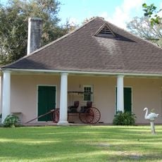
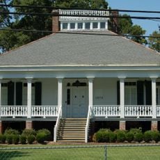
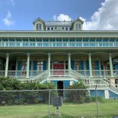
Ormond Plantation House, human settlement in St. Charles Parish, Louisiana, United States of America

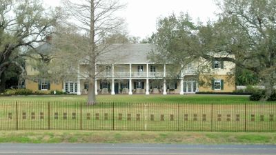
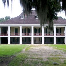
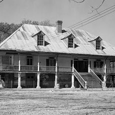
Ormond Plantation House is a large residence built in the late 1700s in Louisiana, designed in French Colonial style and sitting on 16 acres of land. The building features wide galleries supported by heavy columns, thick brick walls, and two distinctive wing structures known as garconnieres.

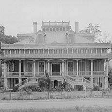
The plantation was established in the late 1780s by Pierre Trépagnier, who received the land from the Spanish government in recognition of his service during the American Revolution. Richard Butler purchased the property in 1805 and gave it its current name, while the plantation experienced changes in ownership and shifted between sugar and rice cultivation.

The house took its name from a castle in Ireland, honoring the Irish roots of its former owner Richard Butler. This naming reflects how the plantation connected distant lands and the families who made it their home.

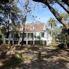
The house is open to visitors today and functions as an event venue, bed and breakfast, and restaurant, with guided tours available. The expansive grounds with mature trees and gardens allow for leisurely exploration of the property and its surroundings.

A notable story describes a mysterious visit to the original owner Pierre Trépagnier during dinner when a servant reported a coach with Spanish markings outside, and Trépagnier met with a well-dressed man before both disappeared as if into thin air. A rare document is a watercolor painting from 1859 that records what the house and surrounding landscape looked like at that time, offering glimpses into daily life more than 150 years ago.

The community of curious travelers

AroundUs brings together thousands of curated places, local tips, and hidden gems, enriched daily by 60,000 contributors worldwide.

Start exploring
GPS coordinates
29.95417,-90.38694
Latest update
February 7, 2026 11:40
Around this place
Huey P. Long Bridge
United States of America

Huey P. Long Bridge

21.1 km
Destrehan Plantation
United States of America

Destrehan Plantation

2.3 km
NOLA Motorsports Park
United States of America

NOLA Motorsports Park

19.9 km
Hale Boggs Memorial Bridge
United States of America

Hale Boggs Memorial Bridge

1.8 km
Bayou Segnette State Park
United States of America

Bayou Segnette State Park

23.1 km
San Francisco Plantation House
United States of America

San Francisco Plantation House

23.6 km
Texas and New Orleans 745
United States of America

Texas and New Orleans 745

23.4 km
The Galleria
United States of America

The Galleria

23.1 km
Cajun Pride Swamp Tours
United States of America

Cajun Pride Swamp Tours

16.4 km
Homeplace Plantation House
United States of America

Homeplace Plantation House

2.7 km
Congregation Beth Israel
United States of America

Congregation Beth Israel

21.5 km
Magnolia Lane Plantation
United States of America

Magnolia Lane Plantation

22.4 km
Camp Parapet
United States of America

Camp Parapet

22.3 km
LaBranche Plantation Dependency
United States of America

LaBranche Plantation Dependency

6.8 km
Segnette Field
United States of America

Segnette Field

22.2 km
Godchaux–Reserve Plantation
United States of America

Godchaux–Reserve Plantation

20.4 km
Wildcat Stadium
United States of America

Wildcat Stadium

1.5 km
Bayou Boeuf Elementary School
United States of America

Bayou Boeuf Elementary School

22.1 km
Emilie Plantation
United States of America

Emilie Plantation

23.8 km
Raziano House
United States of America

Raziano House

13.9 km
Our Lady of Grace Church
United States of America

Our Lady of Grace Church

21 km
Colonial Bowling Center
United States of America

Colonial Bowling Center

18.6 km
Kenner Town Hall
United States of America

Kenner Town Hall

13.6 km
Dorvin House
United States of America

Dorvin House

5 km
San Francisco Plantation
United States of America

San Francisco Plantation

23.3 km
Executive Tower One
United States of America

Executive Tower One

23.1 km
Grand Theater
United States of America

Grand Theater

23.5 km
Montegut Plantation
United States of America

Montegut Plantation

14.8 km
Show the full map
« Ormond Plantation House - human settlement in St. Charles Parish, Louisiana, United States of America » is provided by Around Us (aroundus.com). Images and texts are derived from Wikimedia project under a Creative Commons license. You are allowed to copy, distribute, and modify copies of this page, under the conditions set by the license, as long as this note is clearly visible.

Discover hidden gems everywhere you go!

From secret cafés to breathtaking viewpoints, skip the crowded tourist spots and find places that match your style. Our app makes it easy with voice search, smart filtering, route optimization, and insider tips from travelers worldwide. Download now for the complete mobile experience.

Around Us App Screenshot

A unique approach to discovering new places

Le Figaro

All the places worth exploring

France Info

A tailor-made excursion in just a few clicks

20 Minutes

Around Us
Travel Guide & Maps
Download

Send to your phone

QR Code
1

Open the camera app on your mobile.

2

Point at the QR code with your camera. A notification will appear.

3

Tap the notification to open the link.