Enable Location

We need your location to show you interesting places around you

Discover nearby places

Find interesting locations and hidden gems around you

Precise directions

Get accurate directions and distances to places

Your location is never shared with other users. It's only used when you tap the location button.

Atchafalaya Basin

Log in to your account

Start exploring — it's free

Trusted by 68,083 travelers worldwide

Continue with Google
Continue with Apple
or

We will send you a code to connect

By continuing, you accept our Terms and Conditions and our Privacy Policy

Check your inbox

We've sent a pincode in your inbox. Please enter the code below.

Atchafalaya Basin
Discussion Reviews 2 Photos
69.1k Popularity

Atchafalaya Basin, River swamp in Louisiana, United States

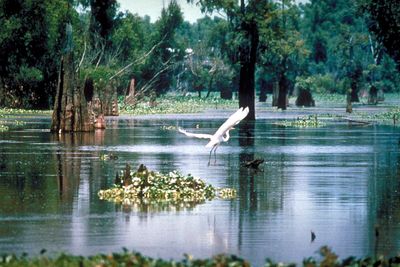
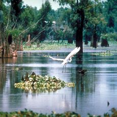
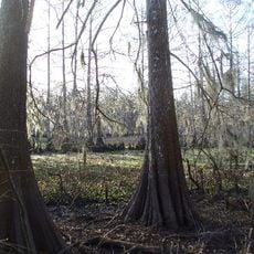
The Atchafalaya Basin is a river swamp in Louisiana that stretches from Simmesport to the Gulf of Mexico and covers hardwood forests, wetlands, and slow channels. Cypress trees rise from the water, their knobby roots breaking the brown surface, while channels wind through thick vegetation.

The river system wandered across the plain over thousands of years, depositing sediment that shaped the wetlands. The Red River once flowed into the swamp before joining the Mississippi, changing the course of the waterways.

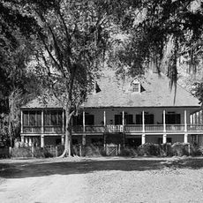
The waterways of the swamp lead to scattered homes where families live and work, often reachable only by boat. Fishermen cast nets between cypress trunks while local children learn to trap crawfish and navigate the winding channels.

Small boats and canoes offer the best way to enter the narrow channels and watch wildlife. Tours usually leave in the morning when humidity is lower and more animals are active.

The swamp holds the largest nesting group of bald eagles in the south central region. These raptors build their nests high in the cypress canopy above the water.

The community of curious travelers

AroundUs brings together thousands of curated places, local tips, and hidden gems, enriched daily by 60,000 contributors worldwide.

Start exploring
Location
GPS coordinates
30.36390,-91.63330
Latest update
December 13, 2025 17:55
Around this place
Atchafalaya Basin Bridge
United States of America

Atchafalaya Basin Bridge

12.6 km
Atchafalaya National Wildlife Refuge
United States of America

Atchafalaya National Wildlife Refuge

21.6 km
Parlange Plantation House
United States of America

Parlange Plantation House

32.8 km
Lake Fausse Pointe State Park
United States of America

Lake Fausse Pointe State Park

33.9 km
Longfellow-Evangeline State Historic Site
United States of America

Longfellow-Evangeline State Historic Site

31.6 km
Allendale Plantation
United States of America

Allendale Plantation

37.9 km
St. Martin of Tours Catholic Church
United States of America

St. Martin of Tours Catholic Church

32.7 km
Krotz Springs Bridge
United States of America

Krotz Springs Bridge

23.2 km
Riverlake
United States of America

Riverlake

33.1 km
Vermilionville Historic Village
United States of America

Vermilionville Historic Village

38.6 km
Charles H. Mouton House
United States of America

Charles H. Mouton House

39.1 km
Maison Olivier
United States of America

Maison Olivier

31.2 km
El Dorado Plantation
United States of America

El Dorado Plantation

19.5 km
Smithfield Plantation
United States of America

Smithfield Plantation

38.8 km
Valverda Plantation
United States of America

Valverda Plantation

21.2 km
Plaquemine Historic District
United States of America

Plaquemine Historic District

39 km
Church of the Nativity
United States of America

Church of the Nativity

19.6 km
Jean Baptiste Bergeron House
United States of America

Jean Baptiste Bergeron House

36.7 km
Austerlitz
United States of America

Austerlitz

32.3 km
Bank of Addis
United States of America

Bank of Addis

35.3 km
St. Martin Parish Courthouse
United States of America

St. Martin Parish Courthouse

33.2 km
Fontenette-Bienvenu House
United States of America

Fontenette-Bienvenu House

32.6 km
Bonin House
United States of America

Bonin House

32.3 km
Patin House
United States of America

Patin House

27.6 km
Dautreuil House
United States of America

Dautreuil House

32.6 km
Longfellow-Evangeline State Historic Site
United States of America

Longfellow-Evangeline State Historic Site

31.1 km
Acadian Cultural Center
United States of America

Acadian Cultural Center

38.5 km
Bayou Teche LA 3361 Bridge
United States of America

Bayou Teche LA 3361 Bridge

27.2 km
Show the full map
Reviews
Share your experience

No review yet

Discussions
Start a discussion...

No discussion yet

« Atchafalaya Basin - River swamp in Louisiana, United States » is provided by Around Us (aroundus.com). Images and texts are derived from Wikimedia project under a Creative Commons license. You are allowed to copy, distribute, and modify copies of this page, under the conditions set by the license, as long as this note is clearly visible.

Discover hidden gems everywhere you go!

From secret cafés to breathtaking viewpoints, skip the crowded tourist spots and find places that match your style. Our app makes it easy with voice search, smart filtering, route optimization, and insider tips from travelers worldwide. Download now for the complete mobile experience.

Around Us App Screenshot

A unique approach to discovering new places

Le Figaro

All the places worth exploring

France Info

A tailor-made excursion in just a few clicks

20 Minutes

Around Us
Travel Guide & Maps
Download

Send to your phone

QR Code
1

Open the camera app on your mobile.

2

Point at the QR code with your camera. A notification will appear.

3

Tap the notification to open the link.