Chest opened
+${chestReward.xp} XP
Explorer
NOUVEAU ×${chestReward.collectible.quantity}
tapez pour fermer
Chest locked

Open chests in the app

Around Us is built for your phone — chests unlock when you walk, explore and capture nearby places.

Enable Location

We need your location to show you interesting places around you

Discover nearby places

Find interesting locations and hidden gems around you

Precise directions

Get accurate directions and distances to places

Your location is never shared with other users. It's only used when you tap the location button.

Log in to your account

Start exploring — it's free

Trusted by 72,890 travelers worldwide

Continue with Google
Continue with Apple
or

We will send you a code to connect

By continuing, you accept our Terms and Conditions and our Privacy Policy

Check your inbox

We've sent a pincode in your inbox. Please enter the code below.

Narrows Dam
Discussion Reviews Photo
2.5k Popularity

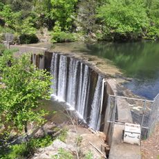
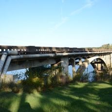
Narrows Dam, Gravity dam in Pike County, Arkansas.

Narrows Dam is a gravity dam spanning 941 feet (287 m) between two bluffs and rising 183.5 feet (56 m) above the Little Missouri River. The structure creates Lake Greeson and houses a powerhouse with generating equipment that produces electricity for the surrounding region.

Construction started in April 1947 under the U.S. Army Corps of Engineers and was completed in 1950. The dedication ceremony took place in July 1951, marking the official opening of this water management facility.

The reservoir was named after Martin White Greeson, who championed water management development in the region starting around 1900. Today the lake shapes how people use and view the surrounding landscape.

The lake is easy to reach and offers good spots for birdwatching and viewing the surrounding landscape. Spring and fall are pleasant times to visit when weather is mild and walking around the reservoir area is comfortable.

The reservoir protects thousands of acres of farmland and homes in the surrounding area from flooding. Its spillway has discharged water only twice since completion, showing how uncommon major flood events are in this region.

The community of curious travelers

AroundUs brings together thousands of curated places, local tips, and hidden gems, enriched daily by 60,000 contributors worldwide.

Start exploring
Location
GPS coordinates
34.14850,-93.71560
Latest update
December 12, 2025 17:41
Around this place
Crater of Diamonds State Park
United States of America

Crater of Diamonds State Park

13.5 km
Nashville High School
United States of America

Nashville High School

22.1 km
Shady Lake Recreation Area
United States of America

Shady Lake Recreation Area

37.5 km
Confederate State Capitol building
United States of America

Confederate State Capitol building

41.3 km
Oak Grove Missionary Baptist Church
United States of America

Oak Grove Missionary Baptist Church

36.5 km
Ebenezer Campground
United States of America

Ebenezer Campground

25.2 km
Elbert W. Holt House
United States of America

Elbert W. Holt House

24.5 km
Mineral Springs Waterworks
United States of America

Mineral Springs Waterworks

35.9 km
Rosenwald School
United States of America

Rosenwald School

27.1 km
Bard Springs Bathhouse
United States of America

Bard Springs Bathhouse

38.2 km
Elkin's Ferry Battlefield
United States of America

Elkin's Ferry Battlefield

41 km
Tall Peak Fire Tower
United States of America

Tall Peak Fire Tower

40.1 km
Old Bank of Amity
United States of America

Old Bank of Amity

26.8 km
Collier Springs Picnic Area
United States of America

Collier Springs Picnic Area

39 km
Howard County Courthouse
United States of America

Howard County Courthouse

25.4 km
Crystal Campground
United States of America

Crystal Campground

37.5 km
Dr. Boaz House
United States of America

Dr. Boaz House

32.8 km
Conway Hotel
United States of America

Conway Hotel

10.2 km
Self Creek Bridge
United States of America

Self Creek Bridge

10.5 km
Caddo Valley Academy Complex
United States of America

Caddo Valley Academy Complex

34.4 km
Womack–Parker House
United States of America

Womack–Parker House

24.8 km
Flavius Holt House
United States of America

Flavius Holt House

24.9 km
Goodlett Gin
United States of America

Goodlett Gin

41.4 km
Loy Kirksey House
United States of America

Loy Kirksey House

39.8 km
Nashville American Legion Building
United States of America

Nashville American Legion Building

27 km
Norman Town Square
United States of America

Norman Town Square

34.2 km
Pike County Courthouse
United States of America

Pike County Courthouse

9.9 km
Shelton-Lockeby House
United States of America

Shelton-Lockeby House

10.5 km
Show the full map
Reviews
Share your experience

No review yet

Discussions
Start a discussion...

No discussion yet

« Narrows Dam - Gravity dam in Pike County, Arkansas » is provided by Around Us (aroundus.com). Images and texts are derived from Wikimedia project under a Creative Commons license. You are allowed to copy, distribute, and modify copies of this page, under the conditions set by the license, as long as this note is clearly visible.

Discover hidden gems everywhere you go!

From secret cafés to breathtaking viewpoints, skip the crowded tourist spots and find places that match your style. Our app makes it easy with voice search, smart filtering, route optimization, and insider tips from travelers worldwide. Download now for the complete mobile experience.

Around Us App Screenshot

A unique approach to discovering new places

Le Figaro

All the places worth exploring

France Info

A tailor-made excursion in just a few clicks

20 Minutes

Around Us
Travel Guide & Maps
Download

Send to your phone

QR Code
1

Open the camera app on your mobile.

2

Point at the QR code with your camera. A notification will appear.

3

Tap the notification to open the link.