Enable Location

We need your location to show you interesting places around you

Discover nearby places

Find interesting locations and hidden gems around you

Precise directions

Get accurate directions and distances to places

Your location is never shared with other users. It's only used when you tap the location button.

Benjamin G. Humphreys Bridge

Log in to your account

Start exploring — it's free

Trusted by 61,820 travelers worldwide

Continue with Google
Continue with Apple
or

We will send you a code to connect

By continuing, you accept our Terms and Conditions and our Privacy Policy

Check your inbox

We've sent a pincode in your inbox. Please enter the code below.

Benjamin G. Humphreys Bridge

Benjamin G. Humphreys Bridge, Cantilever bridge in Lake Village, United States

Description

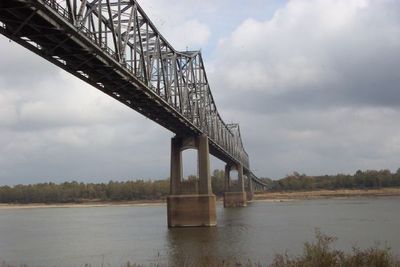
Benjamin G. Humphreys Bridge was a cantilever bridge connecting Lake Village, Arkansas to Greenville, Mississippi, spanning nearly 2 miles across the Mississippi River. The structure featured two lanes but lacked shoulders and modern safety features for the volume of traffic it carried.

History

The Works Progress Administration funded construction during the Great Depression, and it opened in 1940 as the first bridge connecting these two communities. This project replaced earlier, less reliable crossing methods and transformed regional connectivity.

Culture

The bridge was named after Benjamin G. Humphreys II, a U.S. Congressman from Mississippi's Greenville district. It served as a symbol of connection between two communities separated by the river for decades.

Practical

The site sits at a sharp river bend, which limited visibility and made it difficult for large vehicles and barges to maneuver. Visitors should know the bridge closed in 2010 and is no longer passable for traffic.

Did you know?

The main span measured about 840 feet and held the record as the longest highway bridge span on the Mississippi River from 1940 to 1943. After a safer bridge was built downstream, it lost this distinction but remains notable for its engineering achievement.

Location
Inception
October 4, 1940
Official opening
October 4, 1940
GPS coordinates
33.29361,-91.15944
Latest update
December 10, 2025 20:07

AroundUs brings together thousands of curated places, local tips, and hidden gems, enriched daily by 60,000 contributors worldwide. Discover all places nearby (Arkansas).

Around this place
Greenville Bridge
United States of America

Greenville Bridge

864 m
Winterville Site
United States of America

Winterville Site

23.3 km
Mount Holly
United States of America

Mount Holly

24.9 km
Belmont Plantation
United States of America

Belmont Plantation

12.1 km
Lake Chicot State Park
United States of America

Lake Chicot State Park

9.3 km
Leroy Percy State Park
United States of America

Leroy Percy State Park

25.8 km
Junius R. Ward House
United States of America

Junius R. Ward House

23.6 km
First National Bank of Greenville
United States of America

First National Bank of Greenville

15.8 km
Wetherbee House
United States of America

Wetherbee House

16 km
Lake Village Confederate Monument
United States of America

Lake Village Confederate Monument

12.1 km
First Baptist Church
United States of America

First Baptist Church

24.9 km
Greenville Commercial Historic District
United States of America

Greenville Commercial Historic District

15.8 km
Bank of Washington
United States of America

Bank of Washington

15.9 km
Chicot County Courthouse
United States of America

Chicot County Courthouse

12.2 km
American Legion Post No. 127 Building
United States of America

American Legion Post No. 127 Building

22.6 km
U.S. Post Office
United States of America

U.S. Post Office

27.3 km
Washington County Courthouse
United States of America

Washington County Courthouse

16.1 km
Leland Historic District
United States of America

Leland Historic District

27.1 km
Washington School
United States of America

Washington School

16.1 km
Carlton House
United States of America

Carlton House

12 km
Jerome Elementary School No. 22
United States of America

Jerome Elementary School No. 22

31.3 km
John Tushek Building
United States of America

John Tushek Building

12.2 km
Eudora City Hall
United States of America

Eudora City Hall

22.5 km
Lake Village Commercial Historic District
United States of America

Lake Village Commercial Historic District

12.2 km
Naff House
United States of America

Naff House

32.5 km
Old Delta Democrat Times Building
United States of America

Old Delta Democrat Times Building

15.8 km
Dr. A.G. Anderson House
United States of America

Dr. A.G. Anderson House

22.6 km
Rex Theatre
United States of America

Rex Theatre

28.2 km
Show the full map
« Benjamin G. Humphreys Bridge - Cantilever bridge in Lake Village, United States » is provided by Around Us (aroundus.com). Images and texts are derived from Wikimedia project under a Creative Commons license. You are allowed to copy, distribute, and modify copies of this page, under the conditions set by the license, as long as this note is clearly visible.

Discover hidden gems everywhere you go!

From secret cafés to breathtaking viewpoints, skip the crowded tourist spots and find places that match your style. Our app makes it easy with voice search, smart filtering, route optimization, and insider tips from travelers worldwide. Download now for the complete mobile experience.

Around Us App Screenshot

A unique approach to discovering new places

Le Figaro

All the places worth exploring

France Info

A tailor-made excursion in just a few clicks

20 Minutes

Around Us
Travel Guide & Maps
Download

Send to your phone

QR Code
1

Open the camera app on your mobile.

2

Point at the QR code with your camera. A notification will appear.

3

Tap the notification to open the link.