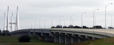
Greenville Bridge, Cable-stayed road bridge between Arkansas and Mississippi, United States
Greenville Bridge is a cable-stayed span carrying US Highway 82 across the Mississippi River with four lanes supported by steel cables anchored to two concrete towers. The deck rises above the water to allow river vessels to pass underneath without affecting road traffic above.
Construction began in 2001 and the bridge opened in 2010, replacing the earlier Benjamin G. Humphreys Bridge that had served the region for decades. The cable-stayed design reflects modern engineering approaches for connecting these two states.
The bridge serves as a daily crossing point for people connecting towns and communities on both sides of the river, shaping how residents and travelers move between the two states.
The bridge handles significant daily traffic and delays can occur during peak hours, so plan accordingly when crossing during busy times. Walking or cycling across is not recommended since this is a high-speed highway route.
The span was engineered to allow large river vessels to pass beneath it, making it a rare example of a high-speed highway doubling as an active shipping corridor. This dual function required special attention to clearance heights and structural design.
Location: Arkansas
Location: Mississippi
Inception: 2001
Official opening: 2010
Part of: United States Numbered Highway System
GPS coordinates: 33.28722,-91.15417
Latest update: December 8, 2025 13:43
Winterville Site
23.7 km
Lakeport Plantation
3.4 km
Benjamin G. Humphreys Bridge
864 m
Mount Holly
24 km
Belmont Plantation
11.4 km
Lake Chicot State Park
10.2 km
Leroy Percy State Park
25 km
Junius R. Ward House
22.7 km
First National Bank of Greenville
16.2 km
Wetherbee House
16.3 km
Lake Village Confederate Monument
12.8 km
First Baptist Church
24.4 km
Greenville Commercial Historic District
16.1 km
Bank of Washington
16.3 km
Chicot County Courthouse
12.9 km
American Legion Post No. 127 Building
22.2 km
U.S. Post Office
27.2 km
Washington County Courthouse
16.4 km
Leland Historic District
27 km
Washington School
16.2 km
Carlton House
12.7 km
Jerome Elementary School No. 22
32 km
Dr. E.P. McGehee Infirmary
13 km
John Tushek Building
12.9 km
Eudora City Hall
22.1 km
Lake Village Commercial Historic District
12.9 km
Naff House
32.9 km
Old Delta Democrat Times Building
16.2 kmVisited this place? Tap the stars to rate it and share your experience / photos with the community! Try now! You can cancel it anytime.
Discover hidden gems everywhere you go!
From secret cafés to breathtaking viewpoints, skip the crowded tourist spots and find places that match your style. Our app makes it easy with voice search, smart filtering, route optimization, and insider tips from travelers worldwide. Download now for the complete mobile experience.
A unique approach to discovering new places❞
— Le Figaro
All the places worth exploring❞
— France Info
A tailor-made excursion in just a few clicks❞
— 20 Minutes