Enable Location

We need your location to show you interesting places around you

Discover nearby places

Find interesting locations and hidden gems around you

Precise directions

Get accurate directions and distances to places

Your location is never shared with other users. It's only used when you tap the location button.

St. Louis Bay Bridge

Log in to your account

Start exploring — it's free

Trusted by 61,344 travelers worldwide

Continue with Google
Continue with Apple
or

We will send you a code to connect

By continuing, you accept our Terms and Conditions and our Privacy Policy

Check your inbox

We've sent a pincode in your inbox. Please enter the code below.

St. Louis Bay Bridge

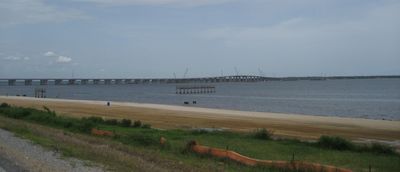
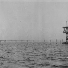
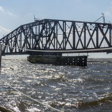
St. Louis Bay Bridge, Road bridge in Bay St. Louis, United States.

Description

The St. Louis Bay Bridge is a road viaduct spanning the Bay of Saint Louis and connecting Bay St. Louis and Pass Christian in Mississippi. The four-lane structure carries U.S. Route 90 traffic and includes a dedicated pedestrian and cycling path on the Gulf side.

History

The original bridge was destroyed by Hurricane Katrina in 2005 and rebuilt with a new structure completed in 2007. The replacement design incorporated enhanced protections against future hurricanes.

Culture

The pedestrian and cycling path on the Gulf side allows visitors to cross the bay on foot or by bicycle while enjoying water views. This passage was deliberately built into the structure to help people connect with the local coastal landscape.

Practical

Four-lane traffic moves across the structure in steady flow, especially during morning and evening rush periods. Pedestrians and cyclists can use the separate path and should prepare for sun exposure and changing weather conditions.

Did you know?

The structure was designed specifically with wind load requirements that exceed standard codes to withstand extreme weather events. Engineers integrated these reinforced qualities during planning to ensure the crossing's durability and safety.

Location
Inception
May 17, 2007
Official opening
May 17, 2007
GPS coordinates
30.31769,-89.30426
Latest update
December 12, 2025 17:44

AroundUs brings together thousands of curated places, local tips, and hidden gems, enriched daily by 60,000 contributors worldwide. Discover all places nearby (Mississippi).

Around this place
Beauvoir
United States of America

Beauvoir

33.2 km
John C. Stennis Space Center
United States of America

John C. Stennis Space Center

28.9 km
Fort Massachusetts
United States of America

Fort Massachusetts

34 km
Jefferson Davis Presidential Library and Museum
United States of America

Jefferson Davis Presidential Library and Museum

33.2 km
Gulfport Combat Readiness Training Center
United States of America

Gulfport Combat Readiness Training Center

15.7 km
Silver Slipper Casino
United States of America

Silver Slipper Casino

14.6 km
Mississippi Aquarium
United States of America

Mississippi Aquarium

21.5 km
Friendship Oak
United States of America

Friendship Oak

16.6 km
Turkey Creek Community Historic District
United States of America

Turkey Creek Community Historic District

24.8 km
Crosby Arboretum
United States of America

Crosby Arboretum

40.4 km
Cat Island Light
United States of America

Cat Island Light

16.8 km
Biloxi National Cemetery
United States of America

Biloxi National Cemetery

36.1 km
Ship Island Light
United States of America

Ship Island Light

34.5 km
CSX Rigolets Pass Bridge
United States of America

CSX Rigolets Pass Bridge

36.2 km
Lynn Meadows Discovery Center
United States of America

Lynn Meadows Discovery Center

26.6 km
United States Post Office and Customhouse
United States of America

United States Post Office and Customhouse

21.1 km
Gulfport Army Air Field Hangar
United States of America

Gulfport Army Air Field Hangar

25.1 km
Pass Christian Light
United States of America

Pass Christian Light

5.2 km
Biloxi Light
United States of America

Biloxi Light

39.6 km
W.J. Quarles House and Cottage
United States of America

W.J. Quarles House and Cottage

15.1 km
East Rigolets Light
United States of America

East Rigolets Light

37.9 km
Merrill Shell Bank Light
United States of America

Merrill Shell Bank Light

9.9 km
Lake Borgne Light
United States of America

Lake Borgne Light

21.4 km
Phare de Broadwater Beach Marina
United States of America

Phare de Broadwater Beach Marina

33.6 km
Grasslawn II
United States of America

Grasslawn II

23.9 km
Rocket Propulsion Test Complex
United States of America

Rocket Propulsion Test Complex

27.7 km
INFINITY Science Center
United States of America

INFINITY Science Center

28.9 km
Gulfport Harbor Square Commercial Historic District
United States of America

Gulfport Harbor Square Commercial Historic District

21.1 km
Show the full map
« St. Louis Bay Bridge - Road bridge in Bay St. Louis, United States » is provided by Around Us (aroundus.com). Images and texts are derived from Wikimedia project under a Creative Commons license. You are allowed to copy, distribute, and modify copies of this page, under the conditions set by the license, as long as this note is clearly visible.

Discover hidden gems everywhere you go!

From secret cafés to breathtaking viewpoints, skip the crowded tourist spots and find places that match your style. Our app makes it easy with voice search, smart filtering, route optimization, and insider tips from travelers worldwide. Download now for the complete mobile experience.

Around Us App Screenshot

A unique approach to discovering new places

Le Figaro

All the places worth exploring

France Info

A tailor-made excursion in just a few clicks

20 Minutes

Around Us
Travel Guide & Maps
Download

Send to your phone

QR Code
1

Open the camera app on your mobile.

2

Point at the QR code with your camera. A notification will appear.

3

Tap the notification to open the link.