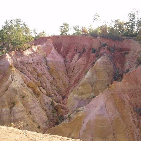
Red Bluff, Natural cliff in Marion County, Mississippi.
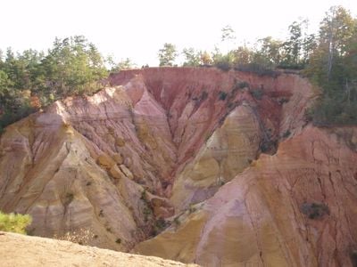
Red Bluff is an eroded cliff on the west bank of the Pearl River in Marion County, about 1.5 miles northwest of Morgantown. Its face of red clay, soil and sand is cut by a central V-shaped ravine into two sharply ridged slopes that drop roughly 200 feet to the river floodplain. The rim, topped by a line of trees, stands at about 371 feet above sea level.
Red Bluff is a natural exposure of red clay, soil, sand and other sediments cut by erosion on the west bank of the Pearl River. The bluff rises to about 371 feet above sea level and drops roughly 200 feet to the river floodplain. Erosion has continued, forcing the relocation of Mississippi Highway 587 at least twice.
Locals call it "Mississippi's Little Grand Canyon," a nickname that has stuck to the bluff above the Pearl River. The land is privately owned, so visitors view the formation from the roadside pull-offs along Mississippi Highway 587 rather than walking it.
The bluff sits on private land about 1.5 miles northwest of Morgantown, so hiking down is not allowed; the formation is viewed from roadside parking along Mississippi Highway 587. The road itself has been moved at least twice because of erosion, so expect the pull-off position to shift.
The bluff's erosion has pushed Mississippi Highway 587 to be moved at least twice, and the view from the rim takes in much of the Pearl River Basin in Marion County plus the eastern part of Columbia, Mississippi. The land itself is privately owned, so hiking is not allowed; the face is seen from roadside parking areas along Highway 587.
The community of curious travelers
AroundUs brings together thousands of curated places, local tips, and hidden gems, enriched daily by 93,032 contributors worldwide.