Enable Location

We need your location to show you interesting places around you

Discover nearby places

Find interesting locations and hidden gems around you

Precise directions

Get accurate directions and distances to places

Your location is never shared with other users. It's only used when you tap the location button.

Batesville Mounds

Log in to your account

Start exploring — it's free

Trusted by 62,441 travelers worldwide

Continue with Google
Continue with Apple
or

We will send you a code to connect

By continuing, you accept our Terms and Conditions and our Privacy Policy

Check your inbox

We've sent a pincode in your inbox. Please enter the code below.

Batesville Mounds, Conial archeological remains of the culture of indigenous people who flourished in North America from 3500 BCE to the 16th century CE

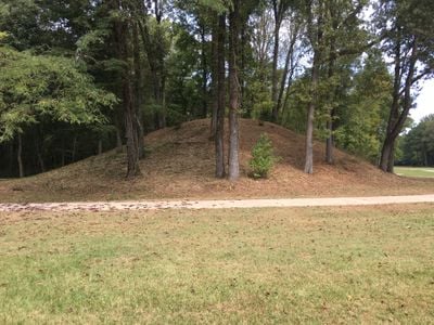
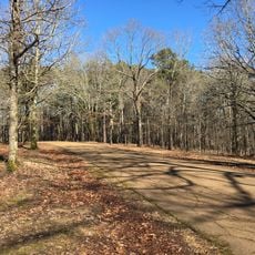
Batesville Mounds is an archaeological site in Panola County with four visible earthen mounds remaining from an original seven. Mound B is a rectangular platform mound rising about 9 feet (3 meters), while Mound C is cone-shaped and about 20 feet (6 meters) tall, with two others appearing as gentle rises across the landscape.

The site was first recorded in 1926 and dates to the Early to Middle Woodland Period, around 1 to 400 AD, when Native Americans built the mounds. Over the decades, some mounds were destroyed or damaged, including the nearby McCarter Mound that disappeared in 1968.

The mounds served as gathering places where communities held ceremonies and honored their ancestors. Visitors walking through the site can sense how these earthen structures shaped the spiritual and social life of the people who built them.

The site features more than 1.5 miles of paved and natural walking trails where visitors can explore the mounds up close. The park covers about 80 acres and is located on Highway 35 North in Batesville, offering plenty of space for walking and observing local plants and wildlife.

Next to the mounds, a historic railroad track from the mid-1800s still runs in use today, creating a direct connection to past transportation routes. Nearby, an old sunken or unused public road is believed to have once been part of the historic Stagecoach Road.

The community of curious travelers

AroundUs brings together thousands of curated places, local tips, and hidden gems, enriched daily by 60,000 contributors worldwide.

Start exploring
Location
Address
515 Highway 35N Batesville, Mississippi 38606
GPS coordinates
34.34750,-89.92390
Latest update
February 9, 2026 07:42
Around this place
Vaught–Hemingway Stadium
United States of America

Vaught–Hemingway Stadium

35.9 km
Rowan Oak
United States of America

Rowan Oak

36.7 km
The Grove
United States of America

The Grove

36 km
Sardis Lake
United States of America

Sardis Lake

13.6 km
Statue of James Meredith
United States of America

Statue of James Meredith

35.6 km
Magnolia Grove Monastery
United States of America

Magnolia Grove Monastery

6.6 km
Lyceum-The Circle Historic District
United States of America

Lyceum-The Circle Historic District

35.8 km
Ammadelle
United States of America

Ammadelle

37.2 km
George P. Cossar State Park
United States of America

George P. Cossar State Park

24.3 km
Sally McDonnell Barksdale Honors College
United States of America

Sally McDonnell Barksdale Honors College

36.1 km
University of Mississippi Power House
United States of America

University of Mississippi Power House

35.9 km
Barnard Observatory
United States of America

Barnard Observatory

35.9 km
University of Mississippi Museum
United States of America

University of Mississippi Museum

36.7 km
Lafayette County Courthouse
United States of America

Lafayette County Courthouse

37.3 km
United States of America

Confederate Monument

35.4 km
Kennon Observatory
United States of America

Kennon Observatory

35.7 km
St. Peter's Episcopal Church
United States of America

St. Peter's Episcopal Church

37.1 km
Oxford Courthouse Square Historic District
United States of America

Oxford Courthouse Square Historic District

37.4 km
Sand Spring Presbyterian Church
United States of America

Sand Spring Presbyterian Church

21.7 km
Holy Innocents' Episcopal Church
United States of America

Holy Innocents' Episcopal Church

18.6 km
Taylor-Falls House
United States of America

Taylor-Falls House

18.6 km
Tate County Courthouse
United States of America

Tate County Courthouse

30.2 km
Downtown Senatobia Historic District
United States of America

Downtown Senatobia Historic District

30.4 km
Lee House
United States of America

Lee House

4.9 km
Lucius Q. C. Lamar House
United States of America

Lucius Q. C. Lamar House

37.7 km
Cotton Warehouse Classic Cars
United States of America

Cotton Warehouse Classic Cars

5.8 km
Como Commercial Historic District
United States of America

Como Commercial Historic District

18.3 km
Batesville Historic District
United States of America

Batesville Historic District

4.4 km
Show the full map
« Batesville Mounds » is provided by Around Us (aroundus.com). Images and texts are derived from Wikimedia project under a Creative Commons license. You are allowed to copy, distribute, and modify copies of this page, under the conditions set by the license, as long as this note is clearly visible.

Discover hidden gems everywhere you go!

From secret cafés to breathtaking viewpoints, skip the crowded tourist spots and find places that match your style. Our app makes it easy with voice search, smart filtering, route optimization, and insider tips from travelers worldwide. Download now for the complete mobile experience.

Around Us App Screenshot

A unique approach to discovering new places

Le Figaro

All the places worth exploring

France Info

A tailor-made excursion in just a few clicks

20 Minutes

Around Us
Travel Guide & Maps
Download

Send to your phone

QR Code
1

Open the camera app on your mobile.

2

Point at the QR code with your camera. A notification will appear.

3

Tap the notification to open the link.