Enable Location

We need your location to show you interesting places around you

Discover nearby places

Find interesting locations and hidden gems around you

Precise directions

Get accurate directions and distances to places

Your location is never shared with other users. It's only used when you tap the location button.

Lyceum-The Circle Historic District

Log in to your account

Start exploring — it's free

Trusted by 66,029 travelers worldwide

Continue with Google
Continue with Apple
or

We will send you a code to connect

By continuing, you accept our Terms and Conditions and our Privacy Policy

Check your inbox

We've sent a pincode in your inbox. Please enter the code below.

Discussion Reviews 1 Photos
3.2k Popularity

Lyceum-The Circle Historic District, Historic landmark district at University of Mississippi, Oxford, US.

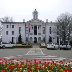
Lyceum-The Circle Historic District is a group of eight historic academic buildings and monuments arranged around a central lawn on the University of Mississippi campus in Oxford. The buildings form a ring around this open space, which serves as the physical center of the university grounds.

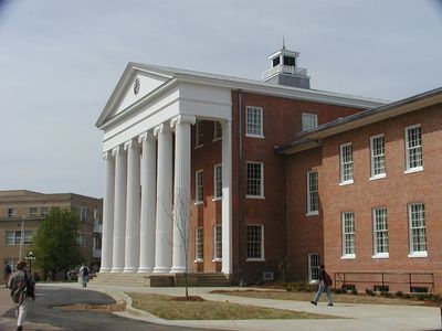
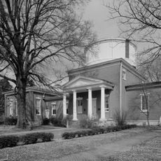
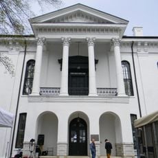
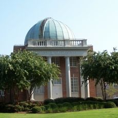
The Lyceum Building went up in 1848 as the first structure on the university grounds, and the surrounding campus grew outward from that starting point over the following decades. The area gained national recognition after events in the 1960s tied it directly to the American civil rights movement.

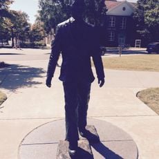
The open lawn of The Circle is a gathering spot where students walk, sit on the grass, and cross between buildings throughout the day. Several monuments placed around the grounds mark moments from the civil rights era that visitors can read and reflect on during a walk.

The district is at the center of campus and easy to reach on foot from any direction. Visiting early in the morning or late in the afternoon on a weekday generally gives you more room to walk around and read the monuments without crowds.

The Lyceum Building was used as a hospital during the Civil War, and bullet marks said to be from that era are still visible on some of its columns today. This makes the building one of the few academic structures in the American South that carries physical traces of wartime use.

The community of curious travelers

AroundUs brings together thousands of curated places, local tips, and hidden gems, enriched daily by 60,000 contributors worldwide.

Start exploring
Location
Architects
William Nichols
GPS coordinates
34.36600,-89.53492
Latest update
March 3, 2026 13:57
Around this place
Vaught–Hemingway Stadium
United States of America

Vaught–Hemingway Stadium

457 m
Rowan Oak
United States of America

Rowan Oak

1.2 km
The Grove
United States of America

The Grove

206 m
Sardis Lake
United States of America

Sardis Lake

24.4 km
Statue of James Meredith
United States of America

Statue of James Meredith

182 m
Wall Doxey State Park
United States of America

Wall Doxey State Park

33 km
United States of America

Lyceum

25.8 km
Ammadelle
United States of America

Ammadelle

1.6 km
Sally McDonnell Barksdale Honors College
United States of America

Sally McDonnell Barksdale Honors College

309 m
University of Mississippi Power House
United States of America

University of Mississippi Power House

275 m
Barnard Observatory
United States of America

Barnard Observatory

45 m
University of Mississippi Museum
United States of America

University of Mississippi Museum

904 m
Lafayette County Courthouse
United States of America

Lafayette County Courthouse

1.5 km
University of Mississippi Field Station
United States of America

University of Mississippi Field Station

15.2 km
United States of America

Confederate Monument

683 m
Kennon Observatory
United States of America

Kennon Observatory

233 m
St. Peter's Episcopal Church
United States of America

St. Peter's Episcopal Church

1.3 km
Oxford Courthouse Square Historic District
United States of America

Oxford Courthouse Square Historic District

1.6 km
Batesville Mounds
United States of America

Batesville Mounds

35.8 km
George Wright Young House
United States of America

George Wright Young House

13.2 km
Sand Spring Presbyterian Church
United States of America

Sand Spring Presbyterian Church

20.6 km
Hopewell Presbyterian Church
United States of America

Hopewell Presbyterian Church

11.8 km
Civil War Earthworks at Tallahatchie Crossing
United States of America

Civil War Earthworks at Tallahatchie Crossing

21.7 km
Lee House
United States of America

Lee House

39.3 km
Lucius Q. C. Lamar House
United States of America

Lucius Q. C. Lamar House

1.9 km
Batesville Historic District
United States of America

Batesville Historic District

38.8 km
North Lamar Historic District
United States of America

North Lamar Historic District

1.6 km
Wall Doxey State Park Historic District
United States of America

Wall Doxey State Park Historic District

33.9 km
Show the full map
Reviews
Share your experience

No review yet

Discussions
Start a discussion...

No discussion yet

« Lyceum-The Circle Historic District - Historic landmark district at University of Mississippi, Oxford, US » is provided by Around Us (aroundus.com). Images and texts are derived from Wikimedia project under a Creative Commons license. You are allowed to copy, distribute, and modify copies of this page, under the conditions set by the license, as long as this note is clearly visible.

Discover hidden gems everywhere you go!

From secret cafés to breathtaking viewpoints, skip the crowded tourist spots and find places that match your style. Our app makes it easy with voice search, smart filtering, route optimization, and insider tips from travelers worldwide. Download now for the complete mobile experience.

Around Us App Screenshot

A unique approach to discovering new places

Le Figaro

All the places worth exploring

France Info

A tailor-made excursion in just a few clicks

20 Minutes

Around Us
Travel Guide & Maps
Download

Send to your phone

QR Code
1

Open the camera app on your mobile.

2

Point at the QR code with your camera. A notification will appear.

3

Tap the notification to open the link.