Sardis Lake

Log in to your account

AroundUs is a community-driven map of interesting places, built by curious explorers like you. It grows with every review, story, and photo you share.
Connect to save your favorite spots, contribute locations, and create personalized routes.
Continue with Google
Continue with Apple
Continue with X
Continue with Facebook
Continue with email
By continuing, you accept our Terms and Conditions and our Privacy Policy
Create an account
Add to collection
Map
Suggest a change
Share

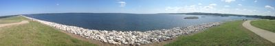
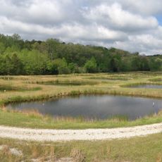
Sardis Lake, Water reservoir in northern Mississippi, United States.

Sardis Lake is a large reservoir on the Tallahatchie River in northern Mississippi, stretching across several counties in the region. The water body features multiple boat ramps, campgrounds, and fishing areas distributed around its shoreline.

The dam was constructed following the Flood Control Act of 1936 and was the first flood control project for the Yazoo River system. The project was built to protect the region from flooding and manage water flow.

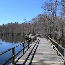
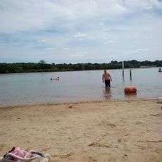
The lake serves as a gathering place where local communities spend time fishing, water sports, and outdoor recreation throughout the year. You will find anglers and boaters along the shores, especially during weekends and fishing tournaments.

Visitors can find multiple boat ramps, camping areas, and fishing spots around the lake, with locations marked on maps at entrance points. It's helpful to check on current conditions and available facilities before your visit.

A special section called Lower Lake was created through dredging operations and covers about 425 acres within the main water body. This area hosts its own recreational facilities and John W. Kyle State Park with dedicated amenities.

Location: Mississippi

GPS coordinates: 34.40890,-89.79580

Latest update: December 7, 2025 19:29

Photos
Around this place
Vaught–Hemingway Stadium
United States of America

Vaught–Hemingway Stadium

24.6 km
Rowan Oak
United States of America

Rowan Oak

25.5 km
The Grove
United States of America

The Grove

24.6 km
Statue of James Meredith
United States of America

Statue of James Meredith

24.3 km
Wall Doxey State Park
United States of America

Wall Doxey State Park

40.9 km
Lyceum-The Circle Historic District
United States of America

Lyceum-The Circle Historic District

24.4 km
Ammadelle
United States of America

Ammadelle

25.7 km
Sally McDonnell Barksdale Honors College
United States of America

Sally McDonnell Barksdale Honors College

24.7 km
University of Mississippi Power House
United States of America

University of Mississippi Power House

24.6 km
Barnard Observatory
United States of America

Barnard Observatory

24.5 km
University of Mississippi Museum
United States of America

University of Mississippi Museum

25.3 km
Lafayette County Courthouse
United States of America

Lafayette County Courthouse

25.9 km
University of Mississippi Field Station
United States of America

University of Mississippi Field Station

37.3 km
United States of America

Confederate Monument

24.2 km
Kennon Observatory
United States of America

Kennon Observatory

24.3 km
St. Peter's Episcopal Church
United States of America

St. Peter's Episcopal Church

25.7 km
Oxford Courthouse Square Historic District
United States of America

Oxford Courthouse Square Historic District

26 km
Batesville Mounds
United States of America

Batesville Mounds

13.6 km
George Wright Young House
United States of America

George Wright Young House

36.9 km
Sand Spring Presbyterian Church
United States of America

Sand Spring Presbyterian Church

18.5 km
Holy Innocents' Episcopal Church
United States of America

Holy Innocents' Episcopal Church

17.8 km
Hopewell Presbyterian Church
United States of America

Hopewell Presbyterian Church

35.3 km
Taylor-Falls House
United States of America

Taylor-Falls House

17.5 km
Civil War Earthworks at Tallahatchie Crossing
United States of America

Civil War Earthworks at Tallahatchie Crossing

32.7 km
Lucius Q. C. Lamar House
United States of America

Lucius Q. C. Lamar House

26.1 km
Lower Lake Beach
United States of America

Lower Lake Beach

976 m
Como Commercial Historic District
United States of America

Como Commercial Historic District

17.6 km
North Lamar Historic District
United States of America

North Lamar Historic District

25.9 km
Show the full map
Reviews

Visited this place? Tap the stars to rate it and share your experience / photos with the community! Try now! You can cancel it anytime.

« Sardis Lake - Water reservoir in northern Mississippi, United States » is provided by Around Us (aroundus.com). Images and texts are derived from Wikimedia project under a Creative Commons license. You are allowed to copy, distribute, and modify copies of this page, under the conditions set by the license, as long as this note is clearly visible.

Discover hidden gems everywhere you go!

From secret cafés to breathtaking viewpoints, skip the crowded tourist spots and find places that match your style. Our app makes it easy with voice search, smart filtering, route optimization, and insider tips from travelers worldwide. Download now for the complete mobile experience.

Around Us App Screenshot

A unique approach to discovering new places

Le Figaro

All the places worth exploring

France Info

A tailor-made excursion in just a few clicks

20 Minutes