Enable Location

We need your location to show you interesting places around you

Discover nearby places

Find interesting locations and hidden gems around you

Precise directions

Get accurate directions and distances to places

Your location is never shared with other users. It's only used when you tap the location button.

Baldwin Village

Log in to your account

Start exploring — it's free

Trusted by 68,238 travelers worldwide

Continue with Google
Continue with Apple
or

We will send you a code to connect

By continuing, you accept our Terms and Conditions and our Privacy Policy

Check your inbox

We've sent a pincode in your inbox. Please enter the code below.

Discussion Reviews 1 Photos
38.9k Popularity

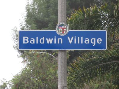
Baldwin Village, Residential district in South Los Angeles, California.

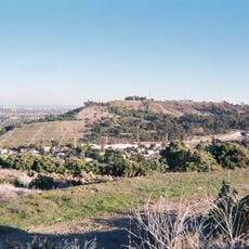
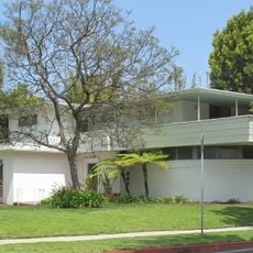
Baldwin Village is a residential neighborhood in South Los Angeles situated between La Brea Avenue, Marlton Avenue, Obama Boulevard, and Martin Luther King Jr Boulevard. The area features tropical trees interspersed among postwar apartment buildings and homes.

The neighborhood took shape during the 1940s and 1950s when architect Clarence Stein developed residential complexes for young families near Baldwin Hills. These early housing projects established the area as a residential community.

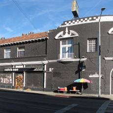
The neighborhood received formal recognition as a distinct community in 1988 through identification signage. Residents gather in the green spaces scattered throughout the postwar residential blocks.

A healthcare facility operated by Kaiser Permanente serves residents with medical services nearby. Walking or driving through the blocks allows you to experience the neighborhood's layout and tree-lined streets.

A major retail development and new residential units have been added to the neighborhood in recent years. This transformation brings expanded shopping options and new life to the established residential area.

The community of curious travelers

AroundUs brings together thousands of curated places, local tips, and hidden gems, enriched daily by 60,000 contributors worldwide.

Start exploring
Location
GPS coordinates
34.01500,-118.34780
Latest update
March 5, 2026 21:06
Around this place
Museum of Jurassic Technology
United States of America

Museum of Jurassic Technology

4.5 km
Baldwin Hills Reservoir
United States of America

Baldwin Hills Reservoir

1.7 km
Kenneth Hahn State Recreation Area
United States of America

Kenneth Hahn State Recreation Area

1.7 km
Jewel's Catch One
United States of America

Jewel's Catch One

4.3 km
Culver Hotel
United States of America

Culver Hotel

4.4 km
First African Methodist Episcopal Church of Los Angeles
United States of America

First African Methodist Episcopal Church of Los Angeles

4.4 km
Kirk Douglas Theatre
United States of America

Kirk Douglas Theatre

4.6 km
William Andrews Clark Memorial Library
United States of America

William Andrews Clark Memorial Library

3.7 km
Wende Museum
United States of America

Wende Museum

4.2 km
Holiday Bowl
United States of America

Holiday Bowl

1.3 km
Bhagavad-gita Museum
United States of America

Bhagavad-gita Museum

4.7 km
Westminster Presbyterian Church
United States of America

Westminster Presbyterian Church

2.8 km
Frederick Hastings Rindge House
United States of America

Frederick Hastings Rindge House

4.4 km
United States of America

Centinela Springs

4.5 km
Ivy Substation
United States of America

Ivy Substation

4.3 km
Eugene W. Britt House
United States of America

Eugene W. Britt House

3.8 km
Engine House No. 18
United States of America

Engine House No. 18

4.3 km
Washington Irving Branch
United States of America

Washington Irving Branch

3.3 km
Ramsay-Durfee Estate
United States of America

Ramsay-Durfee Estate

4.1 km
Paul R. Williams Residence
United States of America

Paul R. Williams Residence

3.5 km
Holmes-Shannon House
United States of America

Holmes-Shannon House

4 km
Van Buren Place Historic District
United States of America

Van Buren Place Historic District

5.2 km
Vermont Square Branch
United States of America

Vermont Square Branch

5.2 km
Angeles Mesa Branch
United States of America

Angeles Mesa Branch

3.7 km
Walter Maciel Gallery
United States of America

Walter Maciel Gallery

3.4 km
Jefferson Branch
United States of America

Jefferson Branch

2.9 km
Citizens Publishing Company Building
United States of America

Citizens Publishing Company Building

4.3 km
Sony Pictures Plaza
United States of America

Sony Pictures Plaza

4.6 km
Show the full map
Reviews
Share your experience

No review yet

Discussions
Start a discussion...

No discussion yet

« Baldwin Village - Residential district in South Los Angeles, California » is provided by Around Us (aroundus.com). Images and texts are derived from Wikimedia project under a Creative Commons license. You are allowed to copy, distribute, and modify copies of this page, under the conditions set by the license, as long as this note is clearly visible.

Discover hidden gems everywhere you go!

From secret cafés to breathtaking viewpoints, skip the crowded tourist spots and find places that match your style. Our app makes it easy with voice search, smart filtering, route optimization, and insider tips from travelers worldwide. Download now for the complete mobile experience.

Around Us App Screenshot

A unique approach to discovering new places

Le Figaro

All the places worth exploring

France Info

A tailor-made excursion in just a few clicks

20 Minutes

Around Us
Travel Guide & Maps
Download

Send to your phone

QR Code
1

Open the camera app on your mobile.

2

Point at the QR code with your camera. A notification will appear.

3

Tap the notification to open the link.