Chest opened
+${chestReward.xp} XP
Explorer
NOUVEAU ×${chestReward.collectible.quantity}
tapez pour fermer
Chest locked

Open chests in the app

Around Us is built for your phone — chests unlock when you walk, explore and capture nearby places.

Enable Location

We need your location to show you interesting places around you

Discover nearby places

Find interesting locations and hidden gems around you

Precise directions

Get accurate directions and distances to places

Your location is never shared with other users. It's only used when you tap the location button.

Log in to your account

Start exploring — it's free

Trusted by 72,889 travelers worldwide

Continue with Google
Continue with Apple
or

We will send you a code to connect

By continuing, you accept our Terms and Conditions and our Privacy Policy

Check your inbox

We've sent a pincode in your inbox. Please enter the code below.

Mashes Sands
Discussion Reviews Photo
1.6k Popularity

Mashes Sands, Coastal recreational area in Panacea, Florida.

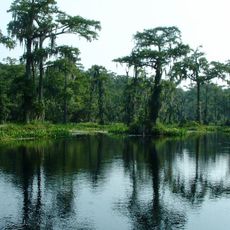
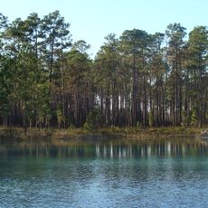
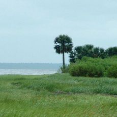
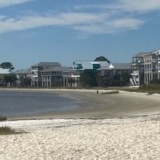
Mashes Sands stretches along the shore where Ochlockonee Bay meets the Gulf of Mexico, featuring white sand beaches and salt marshes. The area offers natural beaches, tidal flats, and shallow bays suited for paddling and fishing.

The location witnessed a naval engagement on July 15, 1863, when the USS Stars and Stripes and USS Somerset conducted operations during the Civil War. This event was part of the coastal battles of that war period in the region.

The beach keeps its natural character and shows the typical Gulf Coast environment of Florida with minimal development. Visitors experience the quiet, undeveloped shoreline as it has been for generations.

The park is open from early morning to midnight with a boat ramp, mobile restrooms, and parking areas. Visitors should bring appropriate footwear since the sandy and marshy areas have varying conditions.

The site offers a paddling route of several miles around Mash Island, leading through shallow waters home to sea trout and redfish. This route connects several small islands and reveals the diversity of the local waters.

The community of curious travelers

AroundUs brings together thousands of curated places, local tips, and hidden gems, enriched daily by 60,000 contributors worldwide.

Start exploring
Location
GPS coordinates
29.97322,-84.34028
Latest update
December 14, 2025 14:21
Around this place
Wakulla Springs
United States of America

Wakulla Springs

29.4 km
Apalachicola National Forest
United States of America

Apalachicola National Forest

50.1 km
St. Marks National Wildlife Refuge
United States of America

St. Marks National Wildlife Refuge

27.1 km
St. Marks Light
United States of America

St. Marks Light

19.1 km
Edward Ball Wakulla Springs State Park
United States of America

Edward Ball Wakulla Springs State Park

28.9 km
Bragg Memorial Stadium
United States of America

Bragg Memorial Stadium

50.6 km
San Marcos de Apalache Historic State Park
United States of America

San Marcos de Apalache Historic State Park

23.4 km
Ochlockonee River State Park
United States of America

Ochlockonee River State Park

14.2 km
Tallahassee Museum
United States of America

Tallahassee Museum

48.6 km
Natural Bridge Battlefield Historic State Park
United States of America

Natural Bridge Battlefield Historic State Park

39.1 km
Tallahassee-St. Marks Historic Railroad Trail State Park
United States of America

Tallahassee-St. Marks Historic Railroad Trail State Park

47.8 km
Carnegie Library at FAMU
United States of America

Carnegie Library at FAMU

50.8 km
Tallahassee Museum Visitor Center
United States of America

Tallahassee Museum Visitor Center

48.7 km
Bellevue Plantation
United States of America

Bellevue Plantation

48.9 km
Crooked River Light
United States of America

Crooked River Light

38.4 km
United States of America

Wakulla State Forest

30.6 km
Camp Gordon Johnston Museum
United States of America

Camp Gordon Johnston Museum

37.6 km
Old Sopchoppy High School Gymnasium
United States of America

Old Sopchoppy High School Gymnasium

17.5 km
Shell Point Beach
United States of America

Shell Point Beach

10.5 km
Flavius C. Coles Farmhouse
United States of America

Flavius C. Coles Farmhouse

51.3 km
Williams House
United States of America

Williams House

51.6 km
Old Wakulla County Courthouse
United States of America

Old Wakulla County Courthouse

22.7 km
Sopchoppy School
United States of America

Sopchoppy School

17.6 km
Mount Beasor Primitive Baptist Church
United States of America

Mount Beasor Primitive Baptist Church

21.5 km
Winterle House
United States of America

Winterle House

48.6 km
San Marcos de Apalache Historic State Park
United States of America

San Marcos de Apalache Historic State Park

23.5 km
Carrabelle History Museum
United States of America

Carrabelle History Museum

34.1 km
Dog Island Light
United States of America

Dog Island Light

37.9 km
Show the full map
Reviews
Share your experience

No review yet

Discussions
Start a discussion...

No discussion yet

« Mashes Sands - Coastal recreational area in Panacea, Florida » is provided by Around Us (aroundus.com). Images and texts are derived from Wikimedia project under a Creative Commons license. You are allowed to copy, distribute, and modify copies of this page, under the conditions set by the license, as long as this note is clearly visible.

Discover hidden gems everywhere you go!

From secret cafés to breathtaking viewpoints, skip the crowded tourist spots and find places that match your style. Our app makes it easy with voice search, smart filtering, route optimization, and insider tips from travelers worldwide. Download now for the complete mobile experience.

Around Us App Screenshot

A unique approach to discovering new places

Le Figaro

All the places worth exploring

France Info

A tailor-made excursion in just a few clicks

20 Minutes

Around Us
Travel Guide & Maps
Download

Send to your phone

QR Code
1

Open the camera app on your mobile.

2

Point at the QR code with your camera. A notification will appear.

3

Tap the notification to open the link.