Enable Location

We need your location to show you interesting places around you

Discover nearby places

Find interesting locations and hidden gems around you

Precise directions

Get accurate directions and distances to places

Your location is never shared with other users. It's only used when you tap the location button.

John U. Lloyd Beach State Park

Log in to your account

Start exploring — it's free

Trusted by 65,418 travelers worldwide

Continue with Google
Continue with Apple
or

We will send you a code to connect

By continuing, you accept our Terms and Conditions and our Privacy Policy

Check your inbox

We've sent a pincode in your inbox. Please enter the code below.

John U. Lloyd Beach State Park
Discussion Reviews 1 Photos
6.7k Popularity

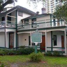
John U. Lloyd Beach State Park, State park in Dania Beach, Florida.

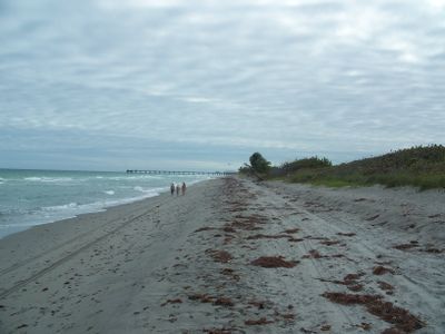
John U. Lloyd Beach State Park is a Florida state park along the Atlantic coast in Dania Beach, Broward County. It covers a stretch of shoreline with sand dunes, mangrove forests, and the sheltered waters of Whiskey Creek, along with picnic areas, boat ramps, and kayak and canoe rentals.

The site opened in 1953 as the designated beach for African Americans in Broward County, at a time when segregation was still enforced by law in Florida. After desegregation in 1962, it became an open public park, and in 2016 it was renamed to honor the activists behind that change.

The park carries the official name Dr. Von D. Mizell-Eula Johnson State Park, honoring two activists who fought for beach desegregation in South Florida. For many African American families in the region, this stretch of coastline holds a personal meaning that goes beyond a typical day at the beach.

Parking areas and restrooms are spread across the grounds, making it easy to find a starting point for your visit. Depending on what you plan to do, bring sun protection and wear shoes suited to sand, water, or the trails along the creek.

Just offshore, the Dania Beach Erojacks artificial reef was created using concrete structures placed on the seafloor to attract marine life. Divers who explore it find a living community that has grown around this man-made formation over the years.

The community of curious travelers

AroundUs brings together thousands of curated places, local tips, and hidden gems, enriched daily by 60,000 contributors worldwide.

Start exploring
Location
Inception
1973
GPS coordinates
26.07000,-80.11306
Latest update
March 3, 2026 10:10
Around this place
International Swimming Hall of Fame
United States of America

International Swimming Hall of Fame

5.2 km
Museum of Discovery and Science
United States of America

Museum of Discovery and Science

6.7 km
Broward Center for the Performing Arts
United States of America

Broward Center for the Performing Arts

6.6 km
Stranahan House
United States of America

Stranahan House

5.9 km
Museum of Art Fort Lauderdale
United States of America

Museum of Art Fort Lauderdale

6.3 km
Bank of America Plaza
United States of America

Bank of America Plaza

6.1 km
Las Olas River House
United States of America

Las Olas River House

6.1 km
110 Tower
United States of America

110 Tower

5.7 km
One Financial Plaza
United States of America

One Financial Plaza

6.4 km
Joseph Wesley Young House
United States of America

Joseph Wesley Young House

6.5 km
PNC Center
United States of America

PNC Center

6.4 km
Snow-Reed Swing Bridge
United States of America

Snow-Reed Swing Bridge

6.7 km
Art and Culture Center of Hollywood
United States of America

Art and Culture Center of Hollywood

7.2 km
St. Anthony School
United States of America

St. Anthony School

6.3 km
Hollywood Woman's Club
United States of America

Hollywood Woman's Club

6.4 km
Bienes Museum of the Modern Book
United States of America

Bienes Museum of the Modern Book

6.4 km
South Side School
United States of America

South Side School

5.6 km
Link Trainer Building
United States of America

Link Trainer Building

4.6 km
Hammerstein House
United States of America

Hammerstein House

6.6 km
Dr. Willard Van Orsdel King House
United States of America

Dr. Willard Van Orsdel King House

3.9 km
Sam Gilliam House
United States of America

Sam Gilliam House

4.8 km
Alfred and Olive Thorpe Lustron House
United States of America

Alfred and Olive Thorpe Lustron House

6.4 km
Croissant Park Administration Building
United States of America

Croissant Park Administration Building

4.7 km
Nyberg-Swanson House
United States of America

Nyberg-Swanson House

3.8 km
Williams House
United States of America

Williams House

5.2 km
E. Clay Shaw, Jr. Bridge
United States of America

E. Clay Shaw, Jr. Bridge

3.5 km
Mad Arts
United States of America

Mad Arts

4.2 km
Naval Air Station Fort Lauderdale Museum
United States of America

Naval Air Station Fort Lauderdale Museum

5.3 km
Show the full map
Reviews
Share your experience

No review yet

Discussions
Start a discussion...

No discussion yet

« John U. Lloyd Beach State Park - State park in Dania Beach, Florida » is provided by Around Us (aroundus.com). Images and texts are derived from Wikimedia project under a Creative Commons license. You are allowed to copy, distribute, and modify copies of this page, under the conditions set by the license, as long as this note is clearly visible.

Discover hidden gems everywhere you go!

From secret cafés to breathtaking viewpoints, skip the crowded tourist spots and find places that match your style. Our app makes it easy with voice search, smart filtering, route optimization, and insider tips from travelers worldwide. Download now for the complete mobile experience.

Around Us App Screenshot

A unique approach to discovering new places

Le Figaro

All the places worth exploring

France Info

A tailor-made excursion in just a few clicks

20 Minutes

Around Us
Travel Guide & Maps
Download

Send to your phone

QR Code
1

Open the camera app on your mobile.

2

Point at the QR code with your camera. A notification will appear.

3

Tap the notification to open the link.