Enable Location

We need your location to show you interesting places around you

Discover nearby places

Find interesting locations and hidden gems around you

Precise directions

Get accurate directions and distances to places

Your location is never shared with other users. It's only used when you tap the location button.

Wabasso Bridge

Log in to your account

Start exploring — it's free

Trusted by 62,557 travelers worldwide

Continue with Google
Continue with Apple
or

We will send you a code to connect

By continuing, you accept our Terms and Conditions and our Privacy Policy

Check your inbox

We've sent a pincode in your inbox. Please enter the code below.

Wabasso Bridge

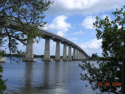
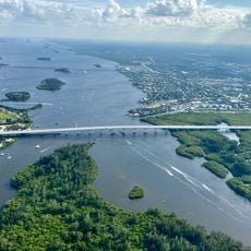
Wabasso Bridge, Deck arch bridge in Indian River County, Florida, US.

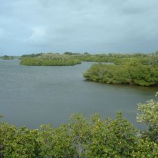
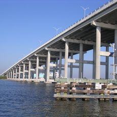
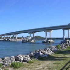
Wabasso Bridge is a concrete arch bridge that carries State Road 510 over the Indian River, connecting inland communities with coastal areas of the Treasure Coast. The structure was designed to provide clearance for boat traffic passing through the Intracoastal Waterway.

A wooden swing bridge built in 1927 originally spanned the Indian River before being replaced in 1970 by the current concrete arch structure. The earlier crossing served the area for more than four decades.

The structure stands near Two Dollar Bluff, a former Ais Indian midden site that contained shells, pottery shards, and bones until 1927.

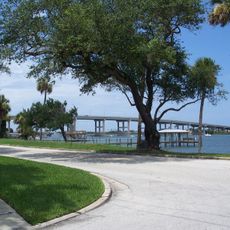
The bridge remains open to regular vehicle traffic, though boat traffic through the waterway beneath may occasionally cause brief delays. Plan to visit during daylight hours for the best views of the structure and surroundings.

The earlier wooden bridge served as a checkpoint during World War II where only island residents could pass after the bridge tender verified their identity. This security measure made crossing the river a restricted privilege for much of the war period.

The community of curious travelers

AroundUs brings together thousands of curated places, local tips, and hidden gems, enriched daily by 60,000 contributors worldwide.

Start exploring
Inception
1970
Official opening
1970
GPS coordinates
27.76140,-80.41610
Latest update
December 14, 2025 12:22
Around this place
Florida State Road A1A
United States of America

Florida State Road A1A

11.3 km
Pelican Island National Wildlife Refuge
United States of America

Pelican Island National Wildlife Refuge

5.9 km
Holman Stadium
United States of America

Holman Stadium

13.1 km
Sebastian Inlet State Park
United States of America

Sebastian Inlet State Park

10.4 km
McLarty Treasure Museum
United States of America

McLarty Treasure Museum

8.3 km
Mel Fisher's Treasure Museum
United States of America

Mel Fisher's Treasure Museum

8.3 km
McKee Botanical Garden
United States of America

McKee Botanical Garden

17.4 km
Merrill P. Barber Bridge
United States of America

Merrill P. Barber Bridge

12.8 km
Alma Lee Loy Bridge
United States of America

Alma Lee Loy Bridge

15 km
Sebastian Inlet Bridge
United States of America

Sebastian Inlet Bridge

11.4 km
Vero Beach Museum of Art
United States of America

Vero Beach Museum of Art

13.3 km
Vero Theatre
United States of America

Vero Theatre

13.7 km
Vero Beach Woman's Club
United States of America

Vero Beach Woman's Club

13.6 km
Old Indian River County Courthouse
United States of America

Old Indian River County Courthouse

13.6 km
Royal Park Arcade
United States of America

Royal Park Arcade

13.8 km
Theodore Hausmann Estate
United States of America

Theodore Hausmann Estate

14.4 km
Judge Henry F. Gregory House
United States of America

Judge Henry F. Gregory House

13.6 km
Indian River Citrus Museum
United States of America

Indian River Citrus Museum

13.6 km
Sebastian Fishing Museum
United States of America

Sebastian Fishing Museum

11.3 km
Old Town Sebastian Historic District, East
United States of America

Old Town Sebastian Historic District, East

8 km
Fellsmere Public School
United States of America

Fellsmere Public School

18.4 km
Sebastian Grammar and Junior High School
United States of America

Sebastian Grammar and Junior High School

8.6 km
Bamma Vickers Lawson House
United States of America

Bamma Vickers Lawson House

7.7 km
First Methodist Episcopal Church
United States of America

First Methodist Episcopal Church

18.2 km
Archie Smith Wholesale Fish Company
United States of America

Archie Smith Wholesale Fish Company

9.5 km
Old Town Sebastian Historic District, West
United States of America

Old Town Sebastian Historic District, West

8.3 km
Osceola Park Historic Residential District
United States of America

Osceola Park Historic Residential District

14 km
St. Helen Catholic Church
United States of America

St. Helen Catholic Church

13.7 km
Show the full map
« Wabasso Bridge - Deck arch bridge in Indian River County, Florida, US » is provided by Around Us (aroundus.com). Images and texts are derived from Wikimedia project under a Creative Commons license. You are allowed to copy, distribute, and modify copies of this page, under the conditions set by the license, as long as this note is clearly visible.

Discover hidden gems everywhere you go!

From secret cafés to breathtaking viewpoints, skip the crowded tourist spots and find places that match your style. Our app makes it easy with voice search, smart filtering, route optimization, and insider tips from travelers worldwide. Download now for the complete mobile experience.

Around Us App Screenshot

A unique approach to discovering new places

Le Figaro

All the places worth exploring

France Info

A tailor-made excursion in just a few clicks

20 Minutes

Around Us
Travel Guide & Maps
Download

Send to your phone

QR Code
1

Open the camera app on your mobile.

2

Point at the QR code with your camera. A notification will appear.

3

Tap the notification to open the link.