Enable Location

We need your location to show you interesting places around you

Discover nearby places

Find interesting locations and hidden gems around you

Precise directions

Get accurate directions and distances to places

Your location is never shared with other users. It's only used when you tap the location button.

Madison County

Log in to your account

Start exploring — it's free

Trusted by travelers worldwide

Continue with Google
Continue with Apple
or

We will send you a code to connect

By continuing, you accept our Terms and Conditions and our Privacy Policy

Check your inbox

We've sent a pincode in your inbox. Please enter the code below.

Madison County, Administrative county in northeastern Georgia, US

Description

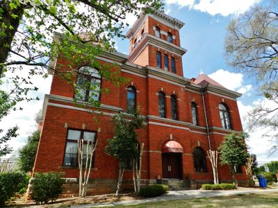
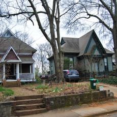
Madison County is an administrative area in northeastern Georgia featuring rolling hills, farmland, and residential neighborhoods spread across the region. The county seat of Danielsville serves as the main hub where local services and community activities are centered.

History

The county was established in 1811 and began operating in 1812 as Georgia's 38th administrative division at a time of expansion. This period marked when the state was organizing new territories into structured local government units.

Culture

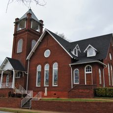
The county takes its name from President James Madison, a reminder that shaped the area's local identity. Community gatherings here happen throughout the year, bringing neighbors together and showing how people maintain their sense of place.

Practical

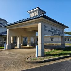
The county is served by schools and local services distributed across several towns and communities. Visitors can explore the area by car and access outdoor parks and rural landscapes that are open to the public.

Did you know?

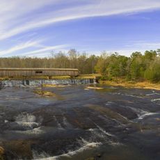
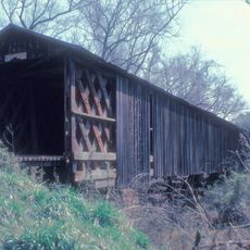
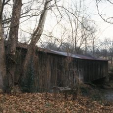
Watson Mill Bridge State Park contains Georgia's longest covered bridge, an architectural structure built using traditional methods that spans the Broad River. This bridge attracts visitors interested in how people built crossings before modern technology.

Location
Inception
December 5, 1811
Capital city
Danielsville
Shares border with
Franklin County, Clarke County, Oglethorpe County, Hart County, Elbert County, Jackson County, Banks County
GPS coordinates
34.13000,-83.21000
Latest update
December 7, 2025 19:26

AroundUs brings together thousands of curated places, local tips, and hidden gems, enriched daily by 60,000 contributors worldwide. Discover all places nearby (Georgia).

Around this place
Sanford Stadium
United States of America

Sanford Stadium

25.1 km
Watson Mill Bridge State Park
United States of America

Watson Mill Bridge State Park

17.1 km
Georgia Theatre
United States of America

Georgia Theatre

24.5 km
Ty Cobb Museum
United States of America

Ty Cobb Museum

19.1 km
Herty Field
United States of America

Herty Field

24.7 km
Lucy Cobb Institute
United States of America

Lucy Cobb Institute

25.5 km
President's House
United States of America

President's House

24.4 km
Henry W. Grady House
United States of America

Henry W. Grady House

24.9 km
Franklin House
United States of America

Franklin House

24.6 km
Downtown Athens Historic District
United States of America

Downtown Athens Historic District

24.4 km
Gospel Pilgrim Cemetery
United States of America

Gospel Pilgrim Cemetery

22.7 km
Camak House
United States of America

Camak House

24.9 km
Epps 1907 Monoplane
United States of America

Epps 1907 Monoplane

24.5 km
Richard B. Russell Library for Political Research and Studies
United States of America

Richard B. Russell Library for Political Research and Studies

24.9 km
Howard's Covered Bridge
United States of America

Howard's Covered Bridge

17.5 km
Joseph Henry Lumpkin House
United States of America

Joseph Henry Lumpkin House

24.7 km
Hebron Church, Cemetery, and Academy
United States of America

Hebron Church, Cemetery, and Academy

22.5 km
Cromer's Mill Covered Bridge
United States of America

Cromer's Mill Covered Bridge

16.9 km
Ware-Lyndon house
United States of America

Ware-Lyndon house

24 km
Clarke County Courthouse
United States of America

Clarke County Courthouse

24.4 km
Cobbham Historic District
United States of America

Cobbham Historic District

25.4 km
First African Methodist Episcopal Church
United States of America

First African Methodist Episcopal Church

24.5 km
Franklin County Courthouse
United States of America

Franklin County Courthouse

26.8 km
Colbert Historic District
United States of America

Colbert Historic District

10.5 km
Hamilton Historic District
United States of America

Hamilton Historic District

26.7 km
Madison County Courthouse
United States of America

Madison County Courthouse

1.2 km
Morton Theatre
United States of America

Morton Theatre

24.6 km
Georgia Theatre
United States of America

Georgia Theatre

24.6 km
Show the full map
Administrative divisions
« Madison County - Administrative county in northeastern Georgia, US » is provided by Around Us (aroundus.com). Images and texts are derived from Wikimedia project under a Creative Commons license. You are allowed to copy, distribute, and modify copies of this page, under the conditions set by the license, as long as this note is clearly visible.

Discover hidden gems everywhere you go!

From secret cafés to breathtaking viewpoints, skip the crowded tourist spots and find places that match your style. Our app makes it easy with voice search, smart filtering, route optimization, and insider tips from travelers worldwide. Download now for the complete mobile experience.

Around Us App Screenshot

A unique approach to discovering new places

Le Figaro

All the places worth exploring

France Info

A tailor-made excursion in just a few clicks

20 Minutes

Around Us
Travel Guide & Maps
Download

Send to your phone

QR Code
1

Open the camera app on your mobile.

2

Point at the QR code with your camera. A notification will appear.

3

Tap the notification to open the link.