Charlesfort-Santa Elena Site

Log in to your account

AroundUs is a community-driven map of interesting places, built by curious explorers like you. It grows with every review, story, and photo you share.
Connect to save your favorite spots, contribute locations, and create personalized routes.
Continue with Google
Continue with Apple
Continue with X
Continue with Facebook
Continue with email
By continuing, you accept our Terms and Conditions and our Privacy Policy
Create an account
Add to collection
Map
Suggest a change
Share

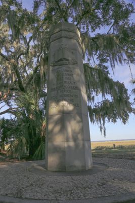
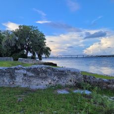
Charlesfort-Santa Elena Site, French and Spanish colonial archaeological site in Parris Island, South Carolina, US.

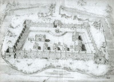
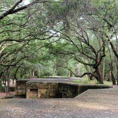
Charlesfort-Santa Elena is an archaeological site on Parris Island containing the remains of two European settlements established during the 1500s. The foundations of buildings, defensive works, and everyday objects recovered here provide direct evidence of early colonial life in this region.

French navigator Jean Ribault founded the first settlement in 1562, but it was abandoned within months due to supply shortages and hardship. Spanish colonists later occupied the same location and built their own settlement there, which lasted longer than the French attempt.

The site reveals how early Europeans and the region's native people first encountered each other and interacted. Artifacts found here show the daily relationships between the groups through shared tools, pottery, and trading practices.

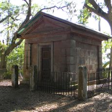
The site is located on Parris Island and features a visitor pavilion with interpretive displays to help you understand the excavations. Plan time to walk the grounds, wear sun and weather protection appropriate for hot, humid conditions, and check ahead for any seasonal visitor programs.

A distinctive feature here is a pottery kiln from the Spanish colonial period, currently the only known surviving example of its kind in North America. This discovery provides rare insight into how the Spanish colonists produced their own ceramics and managed daily production.

Location: Beaufort County

Website: http://pdfhost.focus.nps.gov/docs/NHLS/Text/74001822.pdf

GPS coordinates: 32.30640,-80.67560

Latest update: December 7, 2025 20:23

Photos
Around this place
Beaufort National Cemetery
United States of America

Beaufort National Cemetery

14 km
Pinckney Island National Wildlife Refuge
United States of America

Pinckney Island National Wildlife Refuge

10.9 km
Penn School Historic District
United States of America

Penn School Historic District

13.1 km
Parris Island Museum
United States of America

Parris Island Museum

4.6 km
St. Helena Parish Chapel of Ease Ruins
United States of America

St. Helena Parish Chapel of Ease Ruins

12.1 km
Richard V. Woods Memorial Bridge
United States of America

Richard V. Woods Memorial Bridge

13.5 km
Frogmore Plantation Complex
United States of America

Frogmore Plantation Complex

12.3 km
John Mark Verdier House
United States of America

John Mark Verdier House

13.8 km
Mitchelville Beach
United States of America

Mitchelville Beach

7.1 km
Tombee Plantation
United States of America

Tombee Plantation

4.9 km
The Anchorage
United States of America

The Anchorage

14 km
John A. Cuthbert House
United States of America

John A. Cuthbert House

14 km
Marriott's SurfWatch
United States of America

Marriott's SurfWatch

12.3 km
Burkes Beach
United States of America

Burkes Beach

12.8 km
Edgar Fripp Mausoleum, St. Helena Island Parish Church
United States of America

Edgar Fripp Mausoleum, St. Helena Island Parish Church

12.1 km
Dr. York Bailey House
United States of America

Dr. York Bailey House

13.9 km
Union Church of Port Royal
United States of America

Union Church of Port Royal

8 km
Fort Fremont Battery
United States of America

Fort Fremont Battery

3 km
Fort Fremont Hospital
United States of America

Fort Fremont Hospital

3 km
The Green
United States of America

The Green

13.6 km
St. Luke's Parish Zion Chapel of Ease Cemetery
United States of America

St. Luke's Parish Zion Chapel of Ease Cemetery

11.9 km
The Sands
United States of America

The Sands

7.2 km
Hilton Head Island
United States of America

Hilton Head Island

13.8 km
Folly Field Beach
United States of America

Folly Field Beach

11.6 km
Singleton Beach
United States of America

Singleton Beach

13.3 km
Verdier House
United States of America

Verdier House

13.9 km
Bradley Beach
United States of America

Bradley Beach

12.2 km
Burckmyers Beach
United States of America

Burckmyers Beach

10.3 km
Show the full map
Reviews

Visited this place? Tap the stars to rate it and share your experience / photos with the community! Try now! You can cancel it anytime.

« Charlesfort-Santa Elena Site - French and Spanish colonial archaeological site in Parris Island, South Carolina, US » is provided by Around Us (aroundus.com). Images and texts are derived from Wikimedia project under a Creative Commons license. You are allowed to copy, distribute, and modify copies of this page, under the conditions set by the license, as long as this note is clearly visible.

Discover hidden gems everywhere you go!

From secret cafés to breathtaking viewpoints, skip the crowded tourist spots and find places that match your style. Our app makes it easy with voice search, smart filtering, route optimization, and insider tips from travelers worldwide. Download now for the complete mobile experience.

Around Us App Screenshot

A unique approach to discovering new places

Le Figaro

All the places worth exploring

France Info

A tailor-made excursion in just a few clicks

20 Minutes