Chest opened
+${chestReward.xp} XP
Explorer
NOUVEAU ×${chestReward.collectible.quantity}
tapez pour fermer
Chest locked

Open chests in the app

Around Us is built for your phone — chests unlock when you walk, explore and capture nearby places.

Enable Location

We need your location to show you interesting places around you

Discover nearby places

Find interesting locations and hidden gems around you

Precise directions

Get accurate directions and distances to places

Your location is never shared with other users. It's only used when you tap the location button.

Ogeechee River

Log in to your account

Start exploring — it's free

Trusted by 72,889 travelers worldwide

Continue with Google
Continue with Apple
or

We will send you a code to connect

By continuing, you accept our Terms and Conditions and our Privacy Policy

Check your inbox

We've sent a pincode in your inbox. Please enter the code below.

Ogeechee River
Discussion Reviews 1 Photos
13.6k Popularity

Ogeechee River, Blackwater river in eastern Georgia, United States

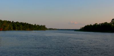
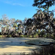
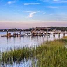
The Ogeechee is a blackwater river in eastern Georgia that flows for about 245 miles through cypress swamps and undeveloped landscapes. Its water has a dark, tea-like color that is natural to this type of river system.

The river was an important place for the Yuchi and other Native American peoples before European settlement, who used it for fishing and transportation. This long presence of Indigenous peoples shaped the land and their deep connection to the water.

The name Ogeechee comes from the Muskogee language and links this river to the Gullah Geechee communities along Georgia's coast. You can sense this connection in the stories and ways of life that people in this region share.

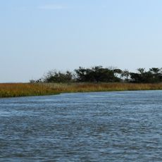
The river has multiple access points between Midville and Herndon for people who want to fish, kayak, or paddle a canoe. Taking time to visit the different launch spots along the way helps you find the one that suits you best.

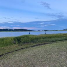
The river keeps its single name throughout its entire journey, a rare quality for waterways in Georgia. This consistency makes it recognizable to boaters and fishers who follow the route with just one name to remember.

The community of curious travelers

AroundUs brings together thousands of curated places, local tips, and hidden gems, enriched daily by 60,000 contributors worldwide.

Start exploring
Location
GPS coordinates
31.83361,-81.02750
Latest update
December 7, 2025 20:25
Around this place
Bonaventure Cemetery
United States of America

Bonaventure Cemetery

23.8 km
Wormsloe Historic Site
United States of America

Wormsloe Historic Site

16.8 km
Skidaway Island State Park
United States of America

Skidaway Island State Park

13.1 km
Wassaw Island
United States of America

Wassaw Island

8.6 km
Bethesda Academy
United States of America

Bethesda Academy

15.4 km
Cockspur Island Light
United States of America

Cockspur Island Light

25.2 km
Fort McAllister
United States of America

Fort McAllister

17.2 km
Ted Wright Stadium
United States of America

Ted Wright Stadium

21.9 km
Fort Morris
United States of America

Fort Morris

25.1 km
Fort McAllister Historic Park
United States of America

Fort McAllister Historic Park

15.4 km
Wormsloe State Historic Site
United States of America

Wormsloe State Historic Site

16.8 km
Ardsley Park-Chatham Crescent Historic District
United States of America

Ardsley Park-Chatham Crescent Historic District

24.8 km
Tybee Island Strand Cottages Historic District
United States of America

Tybee Island Strand Cottages Historic District

24.9 km
Memorial Stadium
United States of America

Memorial Stadium

18.4 km
Wild Heron
United States of America

Wild Heron

23.7 km
Fort McAllister
United States of America

Fort McAllister

17.2 km
Kilkenny
United States of America

Kilkenny

17.3 km
Isle of Hope United Methodist Church
United States of America

Isle of Hope United Methodist Church

16.8 km
Hill Hall at Savannah State College
United States of America

Hill Hall at Savannah State College

21.3 km
Tybee Island Range Front Light
United States of America

Tybee Island Range Front Light

24.9 km
Bryan Neck Presbyterian Church
United States of America

Bryan Neck Presbyterian Church

22.1 km
Eureka Club-Farr's Point
United States of America

Eureka Club-Farr's Point

15.6 km
Dutton-Waller Raised Tybee Cottage
United States of America

Dutton-Waller Raised Tybee Cottage

24.7 km
All Saints Episcopal Church
United States of America

All Saints Episcopal Church

25.5 km
UGA Marine Education Center and Aquarium
United States of America

UGA Marine Education Center and Aquarium

17.2 km
Tybee Beach
United States of America

Tybee Beach

25.5 km
Butter Bean Beach
United States of America

Butter Bean Beach

13.1 km
Fort Pulaski National Monument Visitor Center
United States of America

Fort Pulaski National Monument Visitor Center

25 km
Show the full map
Reviews
Share your experience

No review yet

Discussions
Start a discussion...

No discussion yet

« Ogeechee River - Blackwater river in eastern Georgia, United States » is provided by Around Us (aroundus.com). Images and texts are derived from Wikimedia project under a Creative Commons license. You are allowed to copy, distribute, and modify copies of this page, under the conditions set by the license, as long as this note is clearly visible.

Discover hidden gems everywhere you go!

From secret cafés to breathtaking viewpoints, skip the crowded tourist spots and find places that match your style. Our app makes it easy with voice search, smart filtering, route optimization, and insider tips from travelers worldwide. Download now for the complete mobile experience.

Around Us App Screenshot

A unique approach to discovering new places

Le Figaro

All the places worth exploring

France Info

A tailor-made excursion in just a few clicks

20 Minutes

Around Us
Travel Guide & Maps
Download

Send to your phone

QR Code
1

Open the camera app on your mobile.

2

Point at the QR code with your camera. A notification will appear.

3

Tap the notification to open the link.