Enable Location

We need your location to show you interesting places around you

Discover nearby places

Find interesting locations and hidden gems around you

Precise directions

Get accurate directions and distances to places

Your location is never shared with other users. It's only used when you tap the location button.

General William C. Westmoreland Bridge

Log in to your account

Start exploring — it's free

Trusted by 62,837 travelers worldwide

Continue with Google
Continue with Apple
or

We will send you a code to connect

By continuing, you accept our Terms and Conditions and our Privacy Policy

Check your inbox

We've sent a pincode in your inbox. Please enter the code below.

General William C. Westmoreland Bridge

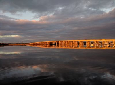
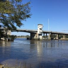
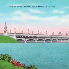
General William C. Westmoreland Bridge, Road bridge across Ashley River in Charleston, United States

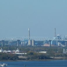
The General William C. Westmoreland Bridge is a road bridge crossing the Ashley River and surrounding marshlands while carrying Interstate 526 traffic with two lanes in each direction. The structure connects two populated areas and allows daily vehicle movement across the waterway.

The bridge was completed in 1980 and created a needed connection between North Charleston and the West Ashley district of Charleston. The structure was an important step in improving traffic flow for the growing region.

The bridge carries the name of General William C. Westmoreland, a South Carolina native who led American military forces during the Vietnam War era. His name remains connected to this major transportation link in the region today.

The bridge is straightforward to drive across in both directions, with two lanes per direction distributing traffic during peak hours. There are no tolls, making this a free route for daily commuters and travelers passing through the area.

The structure was designed with a clearance height of about 35 feet above the water to allow ships and boats to pass underneath. This navigational clearance was important for maintaining boat traffic in this section of the river.

The community of curious travelers

AroundUs brings together thousands of curated places, local tips, and hidden gems, enriched daily by 60,000 contributors worldwide.

Start exploring
Location
GPS coordinates
32.83440,-80.02530
Latest update
December 12, 2025 16:40
Around this place
Magnolia Plantation and Gardens
United States of America

Magnolia Plantation and Gardens

7.2 km
Drayton Hall
United States of America

Drayton Hall

6.3 km
Charleston Naval Shipyard
United States of America

Charleston Naval Shipyard

6.4 km
Charles Towne Landing
United States of America

Charles Towne Landing

4.7 km
Johnson Hagood Stadium
United States of America

Johnson Hagood Stadium

7.9 km
Hampton Park
United States of America

Hampton Park

7.5 km
Magnolia Cemetery
United States of America

Magnolia Cemetery

8 km
Magnolia Plantation
United States of America

Magnolia Plantation

7.4 km
Lowndes Grove
United States of America

Lowndes Grove

6.6 km
Edmondston-Alston House
United States of America

Edmondston-Alston House

7.7 km
Don N. Holt Bridge
United States of America

Don N. Holt Bridge

8.6 km
Warren Lasch Conservation Center
United States of America

Warren Lasch Conservation Center

6.8 km
Charleston Arsenal
United States of America

Charleston Arsenal

9 km
St. Andrews Episcopal Church
United States of America

St. Andrews Episcopal Church

2.3 km
James Sparrow House
United States of America

James Sparrow House

9.1 km
Summerall Chapel
United States of America

Summerall Chapel

7.4 km
Greek Orthodox Church of the Holy Trinity
United States of America

Greek Orthodox Church of the Holy Trinity

8.3 km
Inouye Marksmanship Center
United States of America

Inouye Marksmanship Center

7.1 km
Wappoo Creek Bridge
United States of America

Wappoo Creek Bridge

9 km
Charleston Navy Yard Officers' Quarters Historic District
United States of America

Charleston Navy Yard Officers' Quarters Historic District

6.5 km
William Robb House
United States of America

William Robb House

9 km
Charleston Cemeteries Historic District
United States of America

Charleston Cemeteries Historic District

7.6 km
Standard Oil Company Headquarters
United States of America

Standard Oil Company Headquarters

7.1 km
Charles Towne Landing State Historic Site
United States of America

Charles Towne Landing State Historic Site

4.9 km
Regal Charles Towne Square Stadium 18
United States of America

Regal Charles Towne Square Stadium 18

5 km
Karpeles Manuscript Library Museum, Charleston
United States of America

Karpeles Manuscript Library Museum, Charleston

9 km
Charleston Consolidated Railway, Electric and Gas Company Car House
United States of America

Charleston Consolidated Railway, Electric and Gas Company Car House

8 km
Ashley River Memorial Bridge, Charleston, South Carolina
United States of America

Ashley River Memorial Bridge, Charleston, South Carolina

8.3 km
Show the full map
« General William C. Westmoreland Bridge - Road bridge across Ashley River in Charleston, United States » is provided by Around Us (aroundus.com). Images and texts are derived from Wikimedia project under a Creative Commons license. You are allowed to copy, distribute, and modify copies of this page, under the conditions set by the license, as long as this note is clearly visible.

Discover hidden gems everywhere you go!

From secret cafés to breathtaking viewpoints, skip the crowded tourist spots and find places that match your style. Our app makes it easy with voice search, smart filtering, route optimization, and insider tips from travelers worldwide. Download now for the complete mobile experience.

Around Us App Screenshot

A unique approach to discovering new places

Le Figaro

All the places worth exploring

France Info

A tailor-made excursion in just a few clicks

20 Minutes

Around Us
Travel Guide & Maps
Download

Send to your phone

QR Code
1

Open the camera app on your mobile.

2

Point at the QR code with your camera. A notification will appear.

3

Tap the notification to open the link.