Don N. Holt Bridge

Log in to your account

AroundUs is a community-driven map of interesting places, built by curious explorers like you. It grows with every review, story, and photo you share.
Connect to save your favorite spots, contribute locations, and create personalized routes.
By continuing, you accept our Terms and Conditions and our Privacy Policy
Add to collection
Map
Suggest a change
Share

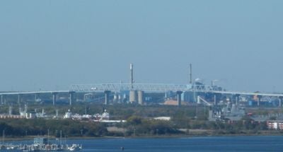
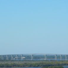
Don N. Holt Bridge, Road truss bridge in Charleston, United States

The Don N. Holt Bridge spans the Cooper River with three continuous spans and carries Interstate 526 between Charleston and North Charleston.

The South Carolina Department of Transportation completed the construction of this bridge in 1992, following design specifications from HNTB Corporation.

The bridge received its name from Don N. Holt, a former member of the South Carolina House of Representatives who worked in insurance.

The structure carries over 72,000 vehicles daily across its six traffic lanes, with a width of 93 feet and a clearance of 155 feet.

The bridge features a road weather information system with illuminating pavement lights to guide vehicles during dense fog conditions.

Location: Charleston

Location: North Charleston

Inception: 1992

GPS coordinates: 32.89113,-79.96299

Latest update: September 23, 2025 16:45

Around this place
Show the full map
Arthur Ravenel Jr. Bridge
United States of America

Arthur Ravenel Jr. Bridge

10.8 km
Boeing South Carolina
United States of America

Boeing South Carolina

6.5 km
Drayton Hall
United States of America

Drayton Hall

10.8 km
Silas N. Pearman Bridge
United States of America

Silas N. Pearman Bridge

10.4 km
Charles Towne Landing
United States of America

Charles Towne Landing

9.6 km
Blackbaud Stadium
United States of America

Blackbaud Stadium

4.6 km
Johnson Hagood Stadium
United States of America

Johnson Hagood Stadium

10.9 km
Hampton Park
United States of America

Hampton Park

10.2 km
Edmondston-Alston House
United States of America

Edmondston-Alston House

3.6 km
Warren Lasch Conservation Center
United States of America

Warren Lasch Conservation Center

3.9 km
William Enston Home
United States of America

William Enston Home

10.1 km
James B. Edwards Bridge
United States of America

James B. Edwards Bridge

7.2 km
Cigar Factory
United States of America

Cigar Factory

10.7 km
General William C. Westmoreland Bridge
United States of America

General William C. Westmoreland Bridge

8.6 km
St. Andrews Episcopal Church
United States of America

St. Andrews Episcopal Church

10 km
Summerall Chapel
United States of America

Summerall Chapel

10.4 km
Greek Orthodox Church of the Holy Trinity
United States of America

Greek Orthodox Church of the Holy Trinity

10.5 km
Inouye Marksmanship Center
United States of America

Inouye Marksmanship Center

10.5 km
Faber House
United States of America

Faber House

11 km
Charleston Navy Yard Officers' Quarters Historic District
United States of America

Charleston Navy Yard Officers' Quarters Historic District

2.5 km
Presqui'ile
United States of America

Presqui'ile

11 km
Charleston Cemeteries Historic District
United States of America

Charleston Cemeteries Historic District

8.5 km
Josiah Smith Tennent House
United States of America

Josiah Smith Tennent House

10.6 km
Standard Oil Company Headquarters
United States of America

Standard Oil Company Headquarters

7.8 km
Emma Abbott Memorial Chapel
United States of America

Emma Abbott Memorial Chapel

10.6 km
Charles Towne Landing State Historic Site
United States of America

Charles Towne Landing State Historic Site

9.6 km
Regal Charles Towne Square Stadium 18
United States of America

Regal Charles Towne Square Stadium 18

4.9 km
Charleston Consolidated Railway, Electric and Gas Company Car House
United States of America

Charleston Consolidated Railway, Electric and Gas Company Car House

9.7 km
Show the full map

Reviews

Visited this place? Tap the stars to rate it and share your experience / photos with the community! Try now! You can cancel it anytime.

« Don N. Holt Bridge: Road truss bridge in Charleston, United States » is provided by Around Us (aroundus.com). Images and texts are derived from Wikimedia project under a Creative Commons license. You are allowed to copy, distribute, and modify copies of this page, under the conditions set by the license, as long as this note is clearly visible.

Discover hidden gems everywhere you go!

From secret cafés to breathtaking viewpoints, skip the crowded tourist spots and find places that match your style. Our app makes it easy with voice search, smart filtering, route optimization, and insider tips from travelers worldwide. Download now for the complete mobile experience.

Around Us App Screenshot

A unique approach to discovering new places

Le Figaro

All the places worth exploring

France Info

A tailor-made excursion in just a few clicks

20 Minutes