Enable Location

We need your location to show you interesting places around you

Discover nearby places

Find interesting locations and hidden gems around you

Precise directions

Get accurate directions and distances to places

Your location is never shared with other users. It's only used when you tap the location button.

Columbia Canal

Log in to your account

Start exploring — it's free

Trusted by 65,813 travelers worldwide

Continue with Google
Continue with Apple
or

We will send you a code to connect

By continuing, you accept our Terms and Conditions and our Privacy Policy

Check your inbox

We've sent a pincode in your inbox. Please enter the code below.

Discussion Reviews 1 Photos
3.9k Popularity

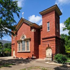
Columbia Canal, Historic waterway in Columbia, South Carolina.

The Columbia Canal is a historic waterway in Richland County, South Carolina, running alongside the Congaree and Broad rivers. It remains operational today, generating hydroelectric power while offering walking paths on both banks for visitors.

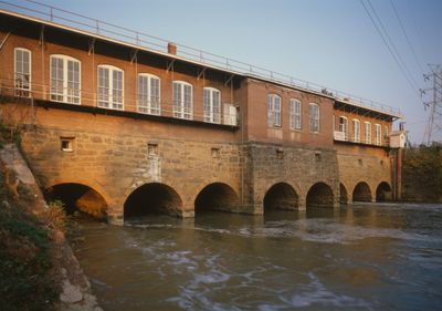
Irish laborers built the canal in 1824 to link inland settlements with trade centers along the Fall Line. In the late 1800s it was rebuilt to generate electricity, shifting its role from transportation to power production.

A granite Irish Memorial stands near the canal to honor the workers who built it. Visitors walking the paths can stop at this monument and read about the people whose labor shaped this waterway.

Walking paths run along both sides of the canal and are accessible to most visitors without any special gear. Visiting on a weekday tends to be quieter than on weekends, when the paths can get busier.

The canal once powered a textile mill that ran electric motors by remote control, which was among the earliest known uses of this technology in the country. The mill showed that electricity could be sent and managed over a distance long before this became common practice.

The community of curious travelers

AroundUs brings together thousands of curated places, local tips, and hidden gems, enriched daily by 60,000 contributors worldwide.

Start exploring
Location
GPS coordinates
34.02083,-81.06194
Latest update
March 3, 2026 14:04
Around this place
Best Friend of Charleston
United States of America

Best Friend of Charleston

2.8 km
Riverbanks Zoo
United States of America

Riverbanks Zoo

1.6 km
South Carolina Governor's Mansion
United States of America

South Carolina Governor's Mansion

2.2 km
South Carolina State Museum
United States of America

South Carolina State Museum

2.8 km
Columbia Museum of Art
United States of America

Columbia Museum of Art

2.9 km
Riverbanks Botanical Garden
United States of America

Riverbanks Botanical Garden

2.2 km
Gervais Street Bridge
United States of America

Gervais Street Bridge

3 km
Lace House
United States of America

Lace House

2.1 km
Arsenal Hill
United States of America

Arsenal Hill

2.3 km
Columbia City Hall
United States of America

Columbia City Hall

2.6 km
Bethel A.M.E. Church
United States of America

Bethel A.M.E. Church

3 km
Ladson Presbyterian Church
United States of America

Ladson Presbyterian Church

2.8 km
Hale-Elmore-Seibels House
United States of America

Hale-Elmore-Seibels House

3 km
J. Bratton Davis United States Bankruptcy Courthouse
United States of America

J. Bratton Davis United States Bankruptcy Courthouse

2.6 km
Mann-Simons Cottage
United States of America

Mann-Simons Cottage

2.7 km
Modjeska Monteith Simkins House
United States of America

Modjeska Monteith Simkins House

2.5 km
South Carolina Memorial Garden
United States of America

South Carolina Memorial Garden

2.1 km
Columbia Historic District I
United States of America

Columbia Historic District I

2.6 km
Debruhl-Marshall House
United States of America

Debruhl-Marshall House

2.8 km
Eau Claire Town Hall and Survey Publishing Company Building
United States of America

Eau Claire Town Hall and Survey Publishing Company Building

2.8 km
Columbia Historic District II
United States of America

Columbia Historic District II

2.8 km
Ebenezer Lutheran Chapel
United States of America

Ebenezer Lutheran Chapel

2.6 km
Harriet M. Cornwell Tourist House
United States of America

Harriet M. Cornwell Tourist House

2.1 km
Bellevue Historic District
United States of America

Bellevue Historic District

2.2 km
Canal Dime Savings Bank
United States of America

Canal Dime Savings Bank

3 km
Caldwell-Hampton-Boylston House
United States of America

Caldwell-Hampton-Boylston House

2.2 km
South Carolina Confederate Relic Room and Military Museum
United States of America

South Carolina Confederate Relic Room and Military Museum

2.7 km
Best Friend of Charleston (1928 replica)
United States of America

Best Friend of Charleston (1928 replica)

2.8 km
Show the full map
Reviews
Share your experience

No review yet

Discussions
Start a discussion...

No discussion yet

« Columbia Canal - Historic waterway in Columbia, South Carolina » is provided by Around Us (aroundus.com). Images and texts are derived from Wikimedia project under a Creative Commons license. You are allowed to copy, distribute, and modify copies of this page, under the conditions set by the license, as long as this note is clearly visible.

Discover hidden gems everywhere you go!

From secret cafés to breathtaking viewpoints, skip the crowded tourist spots and find places that match your style. Our app makes it easy with voice search, smart filtering, route optimization, and insider tips from travelers worldwide. Download now for the complete mobile experience.

Around Us App Screenshot

A unique approach to discovering new places

Le Figaro

All the places worth exploring

France Info

A tailor-made excursion in just a few clicks

20 Minutes

Around Us
Travel Guide & Maps
Download

Send to your phone

QR Code
1

Open the camera app on your mobile.

2

Point at the QR code with your camera. A notification will appear.

3

Tap the notification to open the link.