Enable Location

We need your location to show you interesting places around you

Discover nearby places

Find interesting locations and hidden gems around you

Precise directions

Get accurate directions and distances to places

Your location is never shared with other users. It's only used when you tap the location button.

Log in to your account

Start exploring — it's free

Trusted by 62,043 travelers worldwide

Continue with Google
Continue with Apple
or

We will send you a code to connect

By continuing, you accept our Terms and Conditions and our Privacy Policy

Check your inbox

We've sent a pincode in your inbox. Please enter the code below.

Little Pee Dee State Park

Little Pee Dee State Park, Nature reserve in Dillon County, South Carolina.

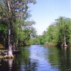
Little Pee Dee State Park is a woodland park in South Carolina centered around Lake Norton and bordered by swamps and sandy shores. The park includes a variety of accommodation options for visitors, from tent sites to RV spaces and one waterfront cabin.

The park was established as a state preserve to protect the natural features of the Atlantic Coastal Plain region. The landscape developed over long periods through natural geological processes that continue to shape the area today.

The park's name honors the Pee Dee Indians who lived in this region, and that heritage remains visible in the landscape and local geography. Walking through the area, you sense this connection to the people who once called this place home.

The park is open during daylight hours and welcomes visitors to hike, fish, and boat on the lake throughout the year. Insect repellent and weather-appropriate clothing are helpful, especially during warmer months when mosquitoes are more active near swampy areas.

The lake allows only electric boat motors, making it one of the quieter fishing spots in the region. This rule helps keep the water peaceful and is appreciated by anglers seeking a calm experience and wildlife watchers exploring from their boats.

The community of curious travelers

AroundUs brings together thousands of curated places, local tips, and hidden gems, enriched daily by 60,000 contributors worldwide.

Start exploring
Location
GPS coordinates
34.32560,-79.27460
Latest update
December 13, 2025 12:41
Around this place
South of the Border
United States of America

South of the Border

19.4 km
Lumber River
United States of America

Lumber River

35 km
Lumber River State Park
United States of America

Lumber River State Park

26.4 km
Smith Tobacco Barn
United States of America

Smith Tobacco Barn

2.7 km
Cotton Press
United States of America

Cotton Press

23 km
Slave Houses, Gregg Plantation
United States of America

Slave Houses, Gregg Plantation

18.8 km
Rankin-Harwell House
United States of America

Rankin-Harwell House

15.7 km
Marion High School
United States of America

Marion High School

19.5 km
Ashpole Presbyterian Church
United States of America

Ashpole Presbyterian Church

25.2 km
Dillon County Courthouse
United States of America

Dillon County Courthouse

13.9 km
St. Paul's Methodist Church
United States of America

St. Paul's Methodist Church

20.6 km
Dillon Downtown Historic District
United States of America

Dillon Downtown Historic District

14.6 km
James W. Dillon House
United States of America

James W. Dillon House

13.8 km
Centenary Methodist Church
United States of America

Centenary Methodist Church

18.7 km
Christ Episcopal Church
United States of America

Christ Episcopal Church

11.9 km
Hamer Hall
United States of America

Hamer Hall

18.5 km
Latta Historic District No. 1
United States of America

Latta Historic District No. 1

14.8 km
James W. Hamer House
United States of America

James W. Hamer House

20.3 km
McMillan House
United States of America

McMillan House

14.8 km
Dillard Barn
United States of America

Dillard Barn

17.9 km
Latta Historic District No. 2
United States of America

Latta Historic District No. 2

14.4 km
Mullins Commercial Historic District
United States of America

Mullins Commercial Historic District

13.7 km
John Hayes Farmstead
United States of America

John Hayes Farmstead

23 km
Rowland Main Street Historic District
United States of America

Rowland Main Street Historic District

23.6 km
Selkirk Farm
United States of America

Selkirk Farm

26.4 km
W.R. Surles Memorial Library
United States of America

W.R. Surles Memorial Library

27.5 km
J.C. Teasley House
United States of America

J.C. Teasley House

13.2 km
Marion Historic District
United States of America

Marion Historic District

20 km
Show the full map
« Little Pee Dee State Park - Nature reserve in Dillon County, South Carolina » is provided by Around Us (aroundus.com). Images and texts are derived from Wikimedia project under a Creative Commons license. You are allowed to copy, distribute, and modify copies of this page, under the conditions set by the license, as long as this note is clearly visible.

Discover hidden gems everywhere you go!

From secret cafés to breathtaking viewpoints, skip the crowded tourist spots and find places that match your style. Our app makes it easy with voice search, smart filtering, route optimization, and insider tips from travelers worldwide. Download now for the complete mobile experience.

Around Us App Screenshot

A unique approach to discovering new places

Le Figaro

All the places worth exploring

France Info

A tailor-made excursion in just a few clicks

20 Minutes

Around Us
Travel Guide & Maps
Download

Send to your phone

QR Code
1

Open the camera app on your mobile.

2

Point at the QR code with your camera. A notification will appear.

3

Tap the notification to open the link.