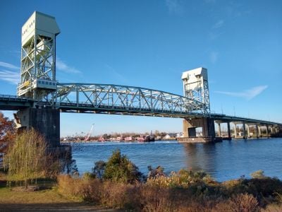
Cape Fear Memorial Bridge, Vertical-lift bridge in Wilmington, North Carolina
The Cape Fear Memorial Bridge is a vertical-lift bridge that spans the Cape Fear River in Wilmington, connecting two counties for vehicle traffic. Its middle section rises up to let ships pass through below.
This bridge opened in 1969 as a major infrastructure project for the region, improving how people could cross the river. Its construction marked an important moment in connecting the two areas on either side of the water.
The structure stands as a central transportation route in Wilmington, carrying US highways 17, 76, and 421 while supporting regional commerce and daily commutes.
The lifting mechanism operates when large ships need to travel upriver, which means traffic stops temporarily while the bridge raises. Drivers should expect delays during these times, especially when vessel traffic is active on the water.
The steel framework of this bridge receives a special hot-dip galvanizing treatment that lasts much longer than traditional paint coatings. This means maintenance work happens less often, which matters for a bridge handling so much daily traffic.
Location: North Carolina
Official opening: October 1, 1969
GPS coordinates: 34.22800,-77.95210
Latest update: December 8, 2025 19:59
USS North Carolina
961 m
Confederate Memorial
904 m
St. Mary Catholic Church
935 m
Temple of Israel
1.1 km
Murchison Building
1.1 km
Wilmington Historic District
788 m
Thalian Hall
1.1 km
The George Davis Monument
1 km
Cape Fear Museum
1.5 km
St. James Episcopal Church
1 km
Cameron Art Museum
6 km
Alton Lennon Federal Building and Courthouse
835 m
Wilmington National Cemetery
2.7 km
Wilmington Riverwalk
1.1 km
First Presbyterian Church
846 m
Burgwin-Wright House and Gardens
960 m
Sunset Park Historic District
2.7 km
Oakdale Cemetery
2.6 km
Carolina Heights Historic District
2.1 km
Market Street Mansion District
2.5 km
Joe and Barbara Schwartz Center
1.6 km
Carolina Place Historic District
2.8 km
James Walker Nursing School Quarters
2 km
Ten Pin Alley
7.8 km
Brookwood Historic District
3.4 km
Delgrado School
2.7 km
Westbrook–Ardmore Historic District
2.3 km
Northside Swimming Pool and Splash Pad
2.8 kmVisited this place? Tap the stars to rate it and share your experience / photos with the community! Try now! You can cancel it anytime.
Discover hidden gems everywhere you go!
From secret cafés to breathtaking viewpoints, skip the crowded tourist spots and find places that match your style. Our app makes it easy with voice search, smart filtering, route optimization, and insider tips from travelers worldwide. Download now for the complete mobile experience.
A unique approach to discovering new places❞
— Le Figaro
All the places worth exploring❞
— France Info
A tailor-made excursion in just a few clicks❞
— 20 Minutes