Enable Location

We need your location to show you interesting places around you

Discover nearby places

Find interesting locations and hidden gems around you

Precise directions

Get accurate directions and distances to places

Your location is never shared with other users. It's only used when you tap the location button.

Pacifica Pier

Log in to your account

Start exploring — it's free

Trusted by 62,840 travelers worldwide

Continue with Google
Continue with Apple
or

We will send you a code to connect

By continuing, you accept our Terms and Conditions and our Privacy Policy

Check your inbox

We've sent a pincode in your inbox. Please enter the code below.

Pacifica Pier

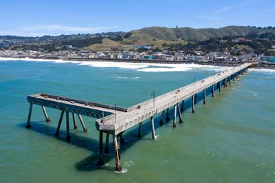
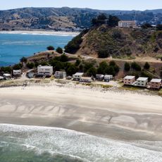
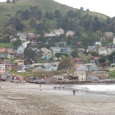
Pacifica Pier, fishing pier

Pacifica Pier is an L-shaped structure made of wood and metal that extends over the ocean at Sharp Park Beach. The platform provides ample space for fishing various species including surfperch, Dungeness crab, and occasionally larger fish, while offering clear sight lines along the entire coastline.

The pier opened in 1973 and was named after Reverend Herschell Harkins, a local minister. It was developed as a community project to provide a safe place where residents could fish and observe wildlife along the coast.

The pier serves as a gathering place where local fishermen share their catches and stories from the water. Over decades, it has become woven into the community's identity, drawing both experienced anglers and visitors who seek a genuine connection to the ocean and coastal life.

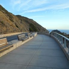
The pier is easily accessible with nearby parking and a visitor center that provides information about whale watching and prime fishing spots. Early morning visits work best when fish are more active and the weather tends to be more stable.

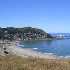
The location is part of the Whale Trail, a network of viewing points along the coast where visitors regularly spot humpback and gray whales that sometimes lift their flukes or breach above the water. This natural spectacle adds an unexpected dimension to what is primarily known as a fishing destination.

The community of curious travelers

AroundUs brings together thousands of curated places, local tips, and hidden gems, enriched daily by 60,000 contributors worldwide.

Start exploring
Location
GPS coordinates
37.63330,-122.49400
Latest update
February 7, 2026 11:00
Around this place
Olympic Club
United States of America

Olympic Club

8.4 km
Devil's Slide
United States of America

Devil's Slide

6.9 km
San Andreas Lake
United States of America

San Andreas Lake

7.6 km
Gray Whale Cove State Beach
United States of America

Gray Whale Cove State Beach

7.7 km
Pacifica State Beach
United States of America

Pacifica State Beach

3.7 km
South San Francisco Hillside Sign
United States of America

South San Francisco Hillside Sign

7.3 km
San Bruno Mountain State Park
United States of America

San Bruno Mountain State Park

7.8 km
San Francisco Bay Discovery Site
United States of America

San Francisco Bay Discovery Site

4.5 km
Thornton State Beach
United States of America

Thornton State Beach

5.6 km
Shelter Cove, Pacifica, California
United States of America

Shelter Cove, Pacifica, California

4.4 km
Pedro Mountain Road
United States of America

Pedro Mountain Road

5.7 km
Sánchez Adobe Park
United States of America

Sánchez Adobe Park

5 km
Devil's Slide Trail
United States of America

Devil's Slide Trail

6.2 km
South San Francisco Public Library
United States of America

South San Francisco Public Library

5.5 km
Congregation B’nai Israel
United States of America

Congregation B’nai Israel

6.4 km
McNee Ranch State Park
United States of America

McNee Ranch State Park

8.3 km
Gray Whale Cove State Beach
United States of America

Gray Whale Cove State Beach

7.9 km
Leo J. Ryan Federal Building
United States of America

Leo J. Ryan Federal Building

6.1 km
San Pedro Valley County Park
United States of America

San Pedro Valley County Park

7 km
Salem Memorial Park and Garden
United States of America

Salem Memorial Park and Garden

5.8 km
Sharp Park Beach
United States of America

Sharp Park Beach

536 m
Wyatt Earp gravesite
United States of America

Wyatt Earp gravesite

5.9 km
Devils Slide Beach
United States of America

Devils Slide Beach

7.8 km
Phillip Burton Memorial Beach
United States of America

Phillip Burton Memorial Beach

8.2 km
Broderick-Terry Dueling Place
United States of America

Broderick-Terry Dueling Place

8.4 km
San Pedro Beach
United States of America

San Pedro Beach

4 km
Westlake Library
United States of America

Westlake Library

7.1 km
Rockaway Beach
United States of America

Rockaway Beach

2.6 km
Show the full map
« Pacifica Pier - fishing pier » is provided by Around Us (aroundus.com). Images and texts are derived from Wikimedia project under a Creative Commons license. You are allowed to copy, distribute, and modify copies of this page, under the conditions set by the license, as long as this note is clearly visible.

Discover hidden gems everywhere you go!

From secret cafés to breathtaking viewpoints, skip the crowded tourist spots and find places that match your style. Our app makes it easy with voice search, smart filtering, route optimization, and insider tips from travelers worldwide. Download now for the complete mobile experience.

Around Us App Screenshot

A unique approach to discovering new places

Le Figaro

All the places worth exploring

France Info

A tailor-made excursion in just a few clicks

20 Minutes

Around Us
Travel Guide & Maps
Download

Send to your phone

QR Code
1

Open the camera app on your mobile.

2

Point at the QR code with your camera. A notification will appear.

3

Tap the notification to open the link.