Enable Location

We need your location to show you interesting places around you

Discover nearby places

Find interesting locations and hidden gems around you

Precise directions

Get accurate directions and distances to places

Your location is never shared with other users. It's only used when you tap the location button.

Naval Auxiliary Landing Field Santa Rosa

Log in to your account

Start exploring — it's free

Trusted by 63,025 travelers worldwide

Continue with Google
Continue with Apple
or

We will send you a code to connect

By continuing, you accept our Terms and Conditions and our Privacy Policy

Check your inbox

We've sent a pincode in your inbox. Please enter the code below.

Naval Auxiliary Landing Field Santa Rosa
Discussion Reviews 1 Photos
2.4k Popularity

Naval Auxiliary Landing Field Santa Rosa, Former military airfield in Santa Rosa, United States

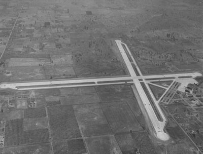
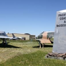
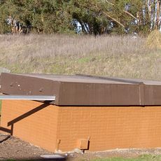
Naval Auxiliary Landing Field Santa Rosa is a former military airfield with two concrete runways, each about 7,000 feet long, laid out at right angles to each other. The property now sits inactive and shows signs of its past use as a training center for fighter planes and other military aircraft.

The facility was commissioned in 1943 and supported training operations for fighter planes, dive bombers, and torpedo bombers during World War II. This airfield played an important role in preparing pilots and aircraft for combat missions in the Pacific theater.

The location served as a major military hub and continues to shape how the area looks and feels today. Its transition from an operational base to an inactive site has changed the way residents and visitors perceive and move through this part of Santa Rosa.

The property requires environmental care due to its military past and current inactive status. Visitors should know that access may be restricted because the site has a brownfield designation with potential soil and groundwater concerns.

The site was used as a filming location for the action film Die Hard 2 in 1990, before being permanently closed in 1991. This Hollywood connection makes it an interesting spot for movie enthusiasts who want to see real locations from well-known productions.

The community of curious travelers

AroundUs brings together thousands of curated places, local tips, and hidden gems, enriched daily by 60,000 contributors worldwide.

Start exploring
Location
Santa Rosa
GPS coordinates
38.41448,-122.76527
Latest update
December 13, 2025 11:42
Around this place
Charles M. Schulz Museum and Research Center
United States of America

Charles M. Schulz Museum and Research Center

5.7 km
McDonald Mansion
United States of America

McDonald Mansion

6.7 km
Taylor Mountain
United States of America

Taylor Mountain

8 km
Luther Burbank Home and Gardens
United States of America

Luther Burbank Home and Gardens

5.3 km
Pacific Coast Air Museum
United States of America

Pacific Coast Air Museum

10.7 km
Luther Burbank Center for the Arts
United States of America

Luther Burbank Center for the Arts

8.9 km
Church of One Tree
United States of America

Church of One Tree

5.1 km
Fountaingrove Lake
United States of America

Fountaingrove Lake

9 km
Luther Burbank's Gold Ridge Experiment Farm
United States of America

Luther Burbank's Gold Ridge Experiment Farm

6.4 km
Rosenberg's Department Store
United States of America

Rosenberg's Department Store

5.6 km
Lake Ralphine
United States of America

Lake Ralphine

9.7 km
Sonoma County Museum
United States of America

Sonoma County Museum

5.1 km
De Turk Round Barn
United States of America

De Turk Round Barn

4.7 km
Roberts Lake
United States of America

Roberts Lake

7.3 km
Ragle Ranch Regional Park
United States of America

Ragle Ranch Regional Park

7.5 km
Copeland Creek
United States of America

Copeland Creek

8.7 km
Washoe Creek
United States of America

Washoe Creek

7.7 km
Hinds Hotel
United States of America

Hinds Hotel

9.1 km
George A. Strout House
United States of America

George A. Strout House

5.7 km
Petaluma and Santa Rosa Railway Powerhouse
United States of America

Petaluma and Santa Rosa Railway Powerhouse

5.2 km
Sonoma State Observatory
United States of America

Sonoma State Observatory

12.1 km
James H. and Frances E. Laughlin House
United States of America

James H. and Frances E. Laughlin House

11.1 km
Children's Museum of Sonoma County
United States of America

Children's Museum of Sonoma County

5.7 km
Fountaingrove Round Barn
United States of America

Fountaingrove Round Barn

7.6 km
Cambria Hotel
United States of America

Cambria Hotel

8 km
Stoke Ranch
United States of America

Stoke Ranch

11.5 km
Wasserman House
United States of America

Wasserman House

5.7 km
Cnopius House
United States of America

Cnopius House

5.8 km
Show the full map
Reviews
Share your experience

No review yet

Discussions
Start a discussion...

No discussion yet

« Naval Auxiliary Landing Field Santa Rosa - Former military airfield in Santa Rosa, United States » is provided by Around Us (aroundus.com). Images and texts are derived from Wikimedia project under a Creative Commons license. You are allowed to copy, distribute, and modify copies of this page, under the conditions set by the license, as long as this note is clearly visible.

Discover hidden gems everywhere you go!

From secret cafés to breathtaking viewpoints, skip the crowded tourist spots and find places that match your style. Our app makes it easy with voice search, smart filtering, route optimization, and insider tips from travelers worldwide. Download now for the complete mobile experience.

Around Us App Screenshot

A unique approach to discovering new places

Le Figaro

All the places worth exploring

France Info

A tailor-made excursion in just a few clicks

20 Minutes

Around Us
Travel Guide & Maps
Download

Send to your phone

QR Code
1

Open the camera app on your mobile.

2

Point at the QR code with your camera. A notification will appear.

3

Tap the notification to open the link.