Enable Location

We need your location to show you interesting places around you

Discover nearby places

Find interesting locations and hidden gems around you

Precise directions

Get accurate directions and distances to places

Your location is never shared with other users. It's only used when you tap the location button.

Lake Ralphine

Log in to your account

Start exploring — it's free

Trusted by 62,442 travelers worldwide

Continue with Google
Continue with Apple
or

We will send you a code to connect

By continuing, you accept our Terms and Conditions and our Privacy Policy

Check your inbox

We've sent a pincode in your inbox. Please enter the code below.

Lake Ralphine

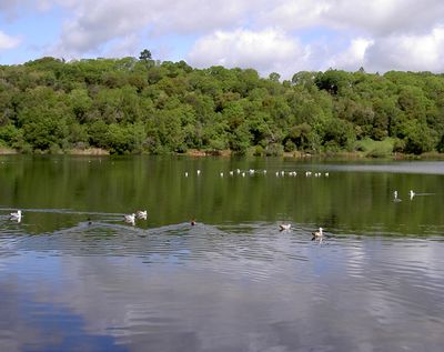
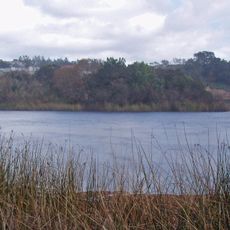
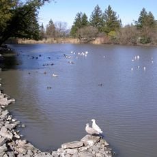
Lake Ralphine, reservoir in Santa Rosa, California

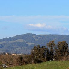
Lake Ralphine is a reservoir in Howarth Memorial Park near Santa Rosa, California. The water is surrounded by gentle trails and framed by trees that provide shade and a natural setting.

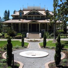
The reservoir was created when Colonel Mark Lindsay McDonald built its dam in 1882. Santa Rosa took ownership in 1947 and transformed it into a public park, establishing it as a community gathering place.

The lake is named after the wife of Colonel Mark Lindsay McDonald, who built the dam in 1882. This personal connection ties the place to the community's local heritage and reminds visitors of the people who shaped it.

Canoes, kayaks, and paddle boats are available for rent during warmer months, with the last launches 30 minutes before closing time. If you bring your own boat, it must be under 20 feet long with an electric motor, and all passengers need life jackets.

The California Department of Fish and Wildlife stocks the lake with trout each year, giving anglers the chance to catch bass, bluegill, and catfish alongside native species. This restocking program keeps the fishing varied and active throughout the year.

The community of curious travelers

AroundUs brings together thousands of curated places, local tips, and hidden gems, enriched daily by 60,000 contributors worldwide.

Start exploring
Location
Inception
1882
GPS coordinates
38.45500,-122.66700
Latest update
February 9, 2026 08:20
Around this place
Petrified Forest
United States of America

Petrified Forest

11.5 km
Charles M. Schulz Museum and Research Center
United States of America

Charles M. Schulz Museum and Research Center

6 km
Safari West
United States of America

Safari West

11.7 km
McDonald Mansion
United States of America

McDonald Mansion

3.3 km
Taylor Mountain
United States of America

Taylor Mountain

6.1 km
Luther Burbank Home and Gardens
United States of America

Luther Burbank Home and Gardens

4.4 km
Trione-Annadel State Park
United States of America

Trione-Annadel State Park

4.7 km
Mount Hood
United States of America

Mount Hood

9.9 km
Luther Burbank Center for the Arts
United States of America

Luther Burbank Center for the Arts

8.3 km
Church of One Tree
United States of America

Church of One Tree

4.6 km
Naval Auxiliary Landing Field Santa Rosa
United States of America

Naval Auxiliary Landing Field Santa Rosa

9.7 km
Fountaingrove Lake
United States of America

Fountaingrove Lake

5.5 km
Sonoma Mountain Zen Center
United States of America

Sonoma Mountain Zen Center

12.5 km
William Hood House
United States of America

William Hood House

8 km
Rosenberg's Department Store
United States of America

Rosenberg's Department Store

4.1 km
Scandia Family Fun Center
United States of America

Scandia Family Fun Center

11.5 km
Sonoma County Museum
United States of America

Sonoma County Museum

4.7 km
Bennett Mountain
United States of America

Bennett Mountain

6 km
De Turk Round Barn
United States of America

De Turk Round Barn

5.2 km
Roberts Lake
United States of America

Roberts Lake

10.7 km
Crane Creek Regional Park
United States of America

Crane Creek Regional Park

12.3 km
Washoe Creek
United States of America

Washoe Creek

13 km
James H. and Frances E. Laughlin House
United States of America

James H. and Frances E. Laughlin House

12 km
Children's Museum of Sonoma County
United States of America

Children's Museum of Sonoma County

6.1 km
Fountaingrove Round Barn
United States of America

Fountaingrove Round Barn

5.8 km
Cambria Hotel
United States of America

Cambria Hotel

12.5 km
Stoke Ranch
United States of America

Stoke Ranch

11.6 km
Wasserman House
United States of America

Wasserman House

4.4 km
Show the full map
« Lake Ralphine - reservoir in Santa Rosa, California » is provided by Around Us (aroundus.com). Images and texts are derived from Wikimedia project under a Creative Commons license. You are allowed to copy, distribute, and modify copies of this page, under the conditions set by the license, as long as this note is clearly visible.

Discover hidden gems everywhere you go!

From secret cafés to breathtaking viewpoints, skip the crowded tourist spots and find places that match your style. Our app makes it easy with voice search, smart filtering, route optimization, and insider tips from travelers worldwide. Download now for the complete mobile experience.

Around Us App Screenshot

A unique approach to discovering new places

Le Figaro

All the places worth exploring

France Info

A tailor-made excursion in just a few clicks

20 Minutes

Around Us
Travel Guide & Maps
Download

Send to your phone

QR Code
1

Open the camera app on your mobile.

2

Point at the QR code with your camera. A notification will appear.

3

Tap the notification to open the link.