Enable Location

We need your location to show you interesting places around you

Discover nearby places

Find interesting locations and hidden gems around you

Precise directions

Get accurate directions and distances to places

Your location is never shared with other users. It's only used when you tap the location button.

Pacific Grove Municipal Golf Links

Log in to your account

Start exploring — it's free

Trusted by 62,050 travelers worldwide

Continue with Google
Continue with Apple
or

We will send you a code to connect

By continuing, you accept our Terms and Conditions and our Privacy Policy

Check your inbox

We've sent a pincode in your inbox. Please enter the code below.

Pacific Grove Municipal Golf Links

Pacific Grove Municipal Golf Links, Public golf course in Pacific Grove, United States

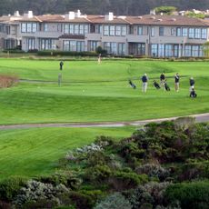
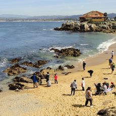
The Pacific Grove Municipal Golf Links is an 18-hole golf course stretching 5,727 yards (5,236 meters) along the California coast. It combines forested terrain with coastal dunes and includes a driving range, practice areas, and a pro shop.

Chandler Egan designed the original nine holes in 1932, establishing the foundation of the course. In 1960, Jack Neville, the creator of Pebble Beach Links, expanded it with a scenic seaside back nine.

The course is regularly used by locals and offers affordable play for Pacific Grove residents. Tournaments and regular events shape the rhythm of the course and connect it to the community's golfing tradition.

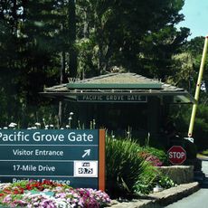
The grounds are accessible throughout the day with clear paths between playing areas for easy navigation. Visitors should be prepared for windy conditions, as the coastal location affects the weather patterns.

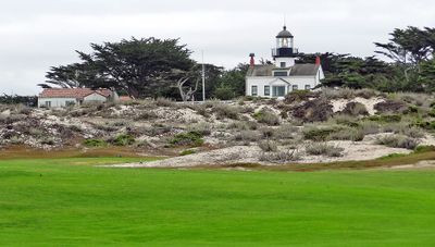
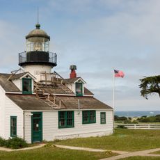
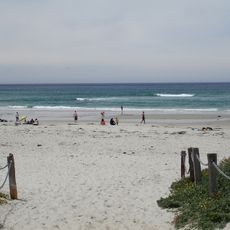
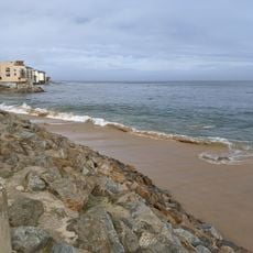
The Point Pinos Lighthouse has operated since 1855 and stands right beside the course, visible from several playing holes. This distinctive landmark adds a blend of golfing and maritime heritage to the playing experience.

The community of curious travelers

AroundUs brings together thousands of curated places, local tips, and hidden gems, enriched daily by 60,000 contributors worldwide.

Start exploring
Location
GPS coordinates
36.63350,-121.93200
Latest update
December 13, 2025 11:44
Around this place
Monterey Bay Aquarium
United States of America

Monterey Bay Aquarium

3.2 km
Asilomar State Beach
United States of America

Asilomar State Beach

1.6 km
Asilomar Conference Grounds
United States of America

Asilomar Conference Grounds

1.5 km
Monterey State Historic Park
United States of America

Monterey State Historic Park

4.8 km
Point Pinos Lighthouse
United States of America

Point Pinos Lighthouse

156 m
Pacific Biological Laboratories
United States of America

Pacific Biological Laboratories

3.4 km
Colton Hall
United States of America

Colton Hall

5 km
Fisherman's Wharf, Monterey, California
United States of America

Fisherman's Wharf, Monterey, California

4.8 km
Old Customhouse
United States of America

Old Customhouse

4.8 km
Asilomar State Marine Reserve
United States of America

Asilomar State Marine Reserve

1.8 km
Edward F. Ricketts State Marine Conservation Area
United States of America

Edward F. Ricketts State Marine Conservation Area

4.7 km
Pacific Grove Museum of Natural History
United States of America

Pacific Grove Museum of Natural History

1.9 km
Monterey Maritime and History Museum
United States of America

Monterey Maritime and History Museum

4.9 km
Wharf Theater
United States of America

Wharf Theater

4.8 km
Vásquez House
United States of America

Vásquez House

5 km
James W. Finch House
United States of America

James W. Finch House

4.6 km
Chautauqua Hall
United States of America

Chautauqua Hall

1.8 km
Trimmer Hill
United States of America

Trimmer Hill

2.6 km
Lou Ellen Parmelee House
United States of America

Lou Ellen Parmelee House

3.5 km
Frank LaVerne Buck House
United States of America

Frank LaVerne Buck House

2.1 km
Josiah Merritt Adobe
United States of America

Josiah Merritt Adobe

4.9 km
Monterey Bay Aquarium
United States of America

Monterey Bay Aquarium

3.2 km
Cannery Row Monument
United States of America

Cannery Row Monument

3.5 km
The Links at Spanish Bay
United States of America

The Links at Spanish Bay

2.5 km
North Moss Beach
United States of America

North Moss Beach

2 km
San Carlos Beach
United States of America

San Carlos Beach

4.2 km
Pacific Grove Gate
United States of America

Pacific Grove Gate

2.3 km
McAbee Beach
United States of America

McAbee Beach

3.5 km
Show the full map
« Pacific Grove Municipal Golf Links - Public golf course in Pacific Grove, United States » is provided by Around Us (aroundus.com). Images and texts are derived from Wikimedia project under a Creative Commons license. You are allowed to copy, distribute, and modify copies of this page, under the conditions set by the license, as long as this note is clearly visible.

Discover hidden gems everywhere you go!

From secret cafés to breathtaking viewpoints, skip the crowded tourist spots and find places that match your style. Our app makes it easy with voice search, smart filtering, route optimization, and insider tips from travelers worldwide. Download now for the complete mobile experience.

Around Us App Screenshot

A unique approach to discovering new places

Le Figaro

All the places worth exploring

France Info

A tailor-made excursion in just a few clicks

20 Minutes

Around Us
Travel Guide & Maps
Download

Send to your phone

QR Code
1

Open the camera app on your mobile.

2

Point at the QR code with your camera. A notification will appear.

3

Tap the notification to open the link.