Enable Location

We need your location to show you interesting places around you

Discover nearby places

Find interesting locations and hidden gems around you

Precise directions

Get accurate directions and distances to places

Your location is never shared with other users. It's only used when you tap the location button.

Mount Sizer

Log in to your account

Start exploring — it's free

Trusted by 61,334 travelers worldwide

Continue with Google
Continue with Apple
or

We will send you a code to connect

By continuing, you accept our Terms and Conditions and our Privacy Policy

Check your inbox

We've sent a pincode in your inbox. Please enter the code below.

Mount Sizer

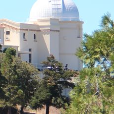
Mount Sizer, Mountain summit in Henry W. Coe State Park, California, US

Description

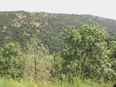
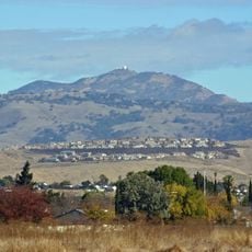
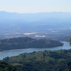
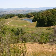
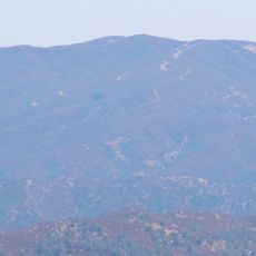
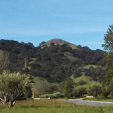
Mount Sizer is a summit in the Diablo Range located within Henry W. Coe State Park, rising to approximately 3,216 feet. Steep trails crisscross the mountain, winding through the terrain and offering expansive views across Santa Clara County from the top.

History

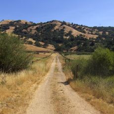
The mountain was accessed via a fire road built in the park's early days to reach Blue Ridge and surrounding areas. This infrastructure reflects early development within California's largest state park.

Culture

Mount Sizer serves as a challenging milestone for hikers participating in the San Francisco Bay Area Classic Peaks Challenge throughout the year.

Practical

The hike to the summit is steep and involves considerable elevation gain, requiring careful preparation. Bring plenty of water since reliable water sources are scarce along the route.

Did you know?

The mountain's northwest slope contains a section called 'The Shortcut' that rises 1,500 feet within 1.3 miles, creating a 22% grade incline.

Location
GPS coordinates
37.21383,-121.51355
Latest update
December 14, 2025 09:40

AroundUs brings together thousands of curated places, local tips, and hidden gems, enriched daily by 60,000 contributors worldwide. Discover all places nearby (California).

Around this place
Lick Observatory
United States of America

Lick Observatory

18.2 km
Mount Hamilton
United States of America

Mount Hamilton

18.3 km
Henry W. Coe State Park
United States of America

Henry W. Coe State Park

4 km
Anderson Lake
United States of America

Anderson Lake

10.5 km
James Lick telescope
United States of America

James Lick telescope

18.2 km
Automated Planet Finder
United States of America

Automated Planet Finder

18.1 km
Villa Mira Monte
United States of America

Villa Mira Monte

15.4 km
C. Donald Shane Telescope
United States of America

C. Donald Shane Telescope

18.1 km
Katzman Automatic Imaging Telescope
United States of America

Katzman Automatic Imaging Telescope

18 km
Crossley telescope
United States of America

Crossley telescope

18.1 km
Sierra Azul Open Space Preserve
United States of America

Sierra Azul Open Space Preserve

22.9 km
Mount Stakes
United States of America

Mount Stakes

15.3 km
Chesbro Reservoir
United States of America

Chesbro Reservoir

20.3 km
Wings of History Museum
United States of America

Wings of History Museum

17 km
Coudé Auxiliary Telescope
United States of America

Coudé Auxiliary Telescope

18.1 km
Anna L. Nickel telescope
United States of America

Anna L. Nickel telescope

18.3 km
Carnegie telescope
United States of America

Carnegie telescope

18.1 km
21-Mile House
United States of America

21-Mile House

16.1 km
Grant Ranch County Park
United States of America

Grant Ranch County Park

21.3 km
Lions Peak
United States of America

Lions Peak

20.4 km
Coyote Grange
United States of America

Coyote Grange

20.1 km
Tulare Hill
United States of America

Tulare Hill

21.4 km
Tauchmann telescope
United States of America

Tauchmann telescope

18.1 km
Edgar Holloway House
United States of America

Edgar Holloway House

23.4 km
Grant Lake
United States of America

Grant Lake

23.4 km
Martin Murphy Middle School
United States of America

Martin Murphy Middle School

22.6 km
Guadalupe River Park & Gardens
United States of America

Guadalupe River Park & Gardens

2.8 km
Copernicus Peak Lookout Tower
United States of America

Copernicus Peak Lookout Tower

18 km
Show the full map
« Mount Sizer - Mountain summit in Henry W. Coe State Park, California, US » is provided by Around Us (aroundus.com). Images and texts are derived from Wikimedia project under a Creative Commons license. You are allowed to copy, distribute, and modify copies of this page, under the conditions set by the license, as long as this note is clearly visible.

Discover hidden gems everywhere you go!

From secret cafés to breathtaking viewpoints, skip the crowded tourist spots and find places that match your style. Our app makes it easy with voice search, smart filtering, route optimization, and insider tips from travelers worldwide. Download now for the complete mobile experience.

Around Us App Screenshot

A unique approach to discovering new places

Le Figaro

All the places worth exploring

France Info

A tailor-made excursion in just a few clicks

20 Minutes

Around Us
Travel Guide & Maps
Download

Send to your phone

QR Code
1

Open the camera app on your mobile.

2

Point at the QR code with your camera. A notification will appear.

3

Tap the notification to open the link.