Hangar One

Log in to your account

AroundUs is a community-driven map of interesting places, built by curious explorers like you. It grows with every review, story, and photo you share.
Connect to save your favorite spots, contribute locations, and create personalized routes.
By continuing, you accept our Terms and Conditions and our Privacy Policy
Add to collection
Map
Suggest a change
Share

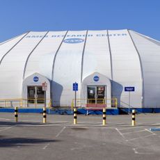
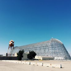
Hangar One, Military hangar at Moffett Federal Airfield, United States

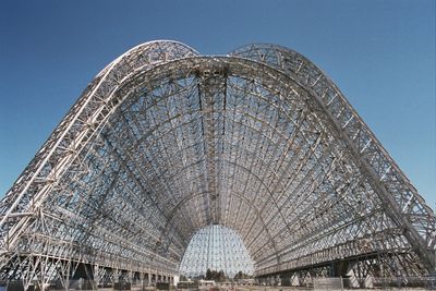
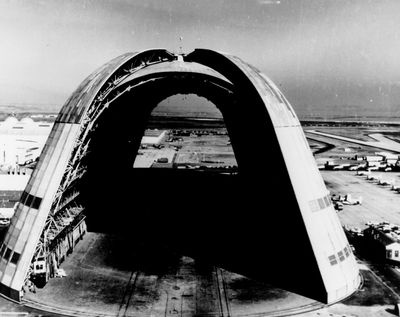
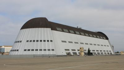
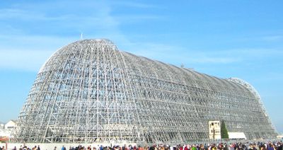
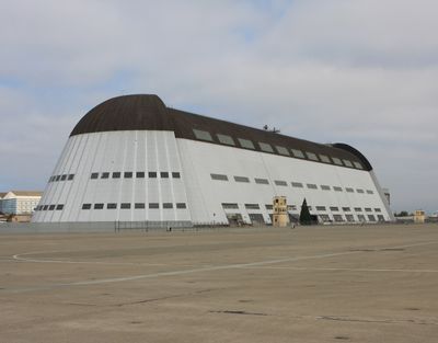
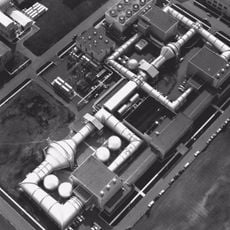
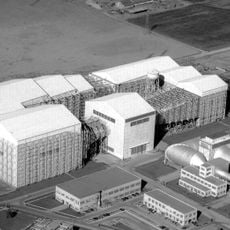
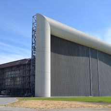
Hangar One is a military hangar at Moffett Federal Airfield in Santa Clara County, measuring 1133 feet (345 meters) in length and 308 feet (94 meters) in width, among the largest freestanding buildings in California. The steel framework was designed to house massive airships and features a curved roof extending across the entire span.

The structure was built in 1933 under the direction of Karl Arnstein to house the naval airship USS Macon, which remained stationed here until its crash in 1935. After the airship era ended, the facility served other military and later civilian aviation projects.

The name recalls the era when this space served as home for naval airships, a chapter still remembered in local tours and regional storytelling. Many people in the surrounding area recognize the structure from outside and associate it with the Bay Area's long aviation tradition.

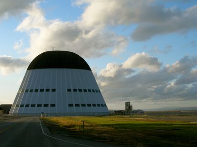
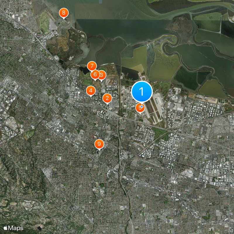
Access to the grounds is restricted since it sits on an active federal airfield, though the exterior remains visible from nearby public roads. The best viewing angles lie along the access routes to the airfield, where the full scale of the structure becomes clear.

The interior space is so large that fog can form near the ceiling under certain temperature conditions, a phenomenon seen in only a few buildings worldwide. The massive clamshell doors each weigh around 200 tons and were designed to minimize wind turbulence when airships moved in and out.

Location: Santa Clara County

Inception: 1933

Architects: Karl Arnstein

Length: 345.34 m

Width: 93.88 m

Part of: Ames Research Center

GPS coordinates: 37.41291,-122.05386

Latest update: December 5, 2025 22:22

Around this place
Show the full map
Computer History Museum
United States of America

Computer History Museum

2.1 km
Shoreline Amphitheatre
United States of America

Shoreline Amphitheatre

2.8 km
Android sculptures
United States of America

Android sculptures

3.1 km
Lunar Orbiter Image Recovery Project
United States of America

Lunar Orbiter Image Recovery Project

403 m
Shoreline Park, Mountain View
United States of America

Shoreline Park, Mountain View

3.2 km
Rengstorff House
United States of America

Rengstorff House

3.6 km
Palo Alto Baylands Nature Preserve
United States of America

Palo Alto Baylands Nature Preserve

6.9 km
Mountain View Center for the Performing Arts
United States of America

Mountain View Center for the Performing Arts

3.6 km
NASA Ames Exploration Center
United States of America

NASA Ames Exploration Center

1 km
Saint Joseph Parish
United States of America

Saint Joseph Parish

3.7 km
Unitary Plan Wind Tunnel
United States of America

Unitary Plan Wind Tunnel

735 m
Sunnyvale Heritage Park Museum
United States of America

Sunnyvale Heritage Park Museum

6.8 km
Los Altos History Museum
United States of America

Los Altos History Museum

6.3 km
Greenmeadow
United States of America

Greenmeadow

5.2 km
Paul Shoup House
United States of America

Paul Shoup House

7.2 km
John W. Christian Greenbelt
United States of America

John W. Christian Greenbelt

3.2 km
Historic Adobe Building
United States of America

Historic Adobe Building

2.8 km
Moffett Field Historical Society Museum
United States of America

Moffett Field Historical Society Museum

149 m
The Foster Museum
United States of America

The Foster Museum

4.2 km
Century Cinema 16
United States of America

Century Cinema 16

2.2 km
Orchard Gardens Park
United States of America

Orchard Gardens Park

2.9 km
40- by 80-Foot Wind Tunnel
United States of America

40- by 80-Foot Wind Tunnel

790 m
Mountain View Public Library
United States of America

Mountain View Public Library

3.6 km
McKelvey Park
United States of America

McKelvey Park

4.2 km
Mountain View Theater
United States of America

Mountain View Theater

3.1 km
80- by 120-Foot Wind Tunnel
United States of America

80- by 120-Foot Wind Tunnel

977 m
3.5-Foot Hypersonic Wind Tunnel
United States of America

3.5-Foot Hypersonic Wind Tunnel

885 m
Google TC1
United States of America

Google TC1

2.2 km
Show the full map

Reviews

Visited this place? Tap the stars to rate it and share your experience / photos with the community! Try now! You can cancel it anytime.

« Hangar One - Military hangar at Moffett Federal Airfield, United States » is provided by Around Us (aroundus.com). Images and texts are derived from Wikimedia project under a Creative Commons license. You are allowed to copy, distribute, and modify copies of this page, under the conditions set by the license, as long as this note is clearly visible.

Discover hidden gems everywhere you go!

From secret cafés to breathtaking viewpoints, skip the crowded tourist spots and find places that match your style. Our app makes it easy with voice search, smart filtering, route optimization, and insider tips from travelers worldwide. Download now for the complete mobile experience.

Around Us App Screenshot

A unique approach to discovering new places

Le Figaro

All the places worth exploring

France Info

A tailor-made excursion in just a few clicks

20 Minutes