Enable Location

We need your location to show you interesting places around you

Discover nearby places

Find interesting locations and hidden gems around you

Precise directions

Get accurate directions and distances to places

Your location is never shared with other users. It's only used when you tap the location button.

Brisbane Baylands development

Log in to your account

Start exploring — it's free

Trusted by 62,836 travelers worldwide

Continue with Google
Continue with Apple
or

We will send you a code to connect

By continuing, you accept our Terms and Conditions and our Privacy Policy

Check your inbox

We've sent a pincode in your inbox. Please enter the code below.

Brisbane Baylands development

Brisbane Baylands development, Mixed-use development site in Brisbane, California

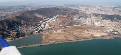
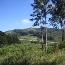
Brisbane Baylands is a large mixed-use development site in California that occupies land between the bay and the highway south of San Francisco. The project will eventually include homes, offices, shops, and public spaces across the entire area.

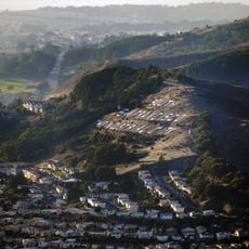
From 1932 to 1967 the land served as San Francisco's main garbage dump, filling in portions of the lagoon to create flat terrain. After decades of industrial use, the site is now transitioning into a neighborhood with mixed purposes.

The development incorporates community input through public meetings and environmental impact reviews to shape the future of this transformative urban project.

The site is accessible by public transit with train connections that link to downtown areas and nearby neighborhoods. Driving is possible via the main highway, though parking can be limited in surrounding areas.

The land requires extensive environmental cleanup before construction can begin due to contamination from its industrial past. This remediation process is a critical step that must be completed before any building work starts.

The community of curious travelers

AroundUs brings together thousands of curated places, local tips, and hidden gems, enriched daily by 60,000 contributors worldwide.

Start exploring
Location
GPS coordinates
37.70700,-122.40400
Latest update
December 12, 2025 14:27
Around this place
Candlestick Point State Recreation Area
United States of America

Candlestick Point State Recreation Area

2.1 km
McLaren Park
United States of America

McLaren Park

1.8 km
Glen Canyon Park
United States of America

Glen Canyon Park

4.9 km
South San Francisco Hillside Sign
United States of America

South San Francisco Hillside Sign

5.2 km
Boxer Stadium
United States of America

Boxer Stadium

4.2 km
Sam Jordan's Bar
United States of America

Sam Jordan's Bar

4 km
San Bruno Mountain State Park
United States of America

San Bruno Mountain State Park

3.6 km
Bernal Heights Summit
United States of America

Bernal Heights Summit

4.1 km
Bayview Opera House
United States of America

Bayview Opera House

3.4 km
Albion Brewery
United States of America

Albion Brewery

3.7 km
Jerry Garcia Amphitheatre
United States of America

Jerry Garcia Amphitheatre

1.9 km
Billy Goat Hill, San Francisco
United States of America

Billy Goat Hill, San Francisco

4.6 km
Cayuga Park
United States of America

Cayuga Park

4.1 km
Quinn House, San Francisco
United States of America

Quinn House, San Francisco

3.5 km
Frank G. Edwards House
United States of America

Frank G. Edwards House

5 km
Cow Palace
United States of America

Cow Palace

1.3 km
United States of America

Hunters View

3.8 km
Bernal Heights Branch Library
United States of America

Bernal Heights Branch Library

3.7 km
Ingleside Branch Library
United States of America

Ingleside Branch Library

5 km
Visitacion Valley Branch Library
United States of America

Visitacion Valley Branch Library

697 m
Glen Park Branch Library
United States of America

Glen Park Branch Library

4 km
Excelsior Branch Library
United States of America

Excelsior Branch Library

3.4 km
Portola Branch Library
United States of America

Portola Branch Library

2.2 km
Mission Branch Library
United States of America

Mission Branch Library

5.2 km
La Grande Tank
United States of America

La Grande Tank

2.5 km
Geneva Office Building and Power House
United States of America

Geneva Office Building and Power House

4 km
Sylvester House
United States of America

Sylvester House

3 km
Endangered Garden
United States of America

Endangered Garden

1.1 km
Show the full map
« Brisbane Baylands development - Mixed-use development site in Brisbane, California » is provided by Around Us (aroundus.com). Images and texts are derived from Wikimedia project under a Creative Commons license. You are allowed to copy, distribute, and modify copies of this page, under the conditions set by the license, as long as this note is clearly visible.

Discover hidden gems everywhere you go!

From secret cafés to breathtaking viewpoints, skip the crowded tourist spots and find places that match your style. Our app makes it easy with voice search, smart filtering, route optimization, and insider tips from travelers worldwide. Download now for the complete mobile experience.

Around Us App Screenshot

A unique approach to discovering new places

Le Figaro

All the places worth exploring

France Info

A tailor-made excursion in just a few clicks

20 Minutes

Around Us
Travel Guide & Maps
Download

Send to your phone

QR Code
1

Open the camera app on your mobile.

2

Point at the QR code with your camera. A notification will appear.

3

Tap the notification to open the link.