Billy Goat Hill, San Francisco

Log in to your account

AroundUs is a community-driven map of interesting places, built by curious explorers like you. It grows with every review, story, and photo you share.
Connect to save your favorite spots, contribute locations, and create personalized routes.
By continuing, you accept our Terms and Conditions and our Privacy Policy

Billy Goat Hill, San Francisco

Add to collection
Map
Suggest a change
Share

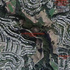
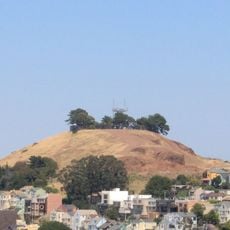
Billy Goat Hill, San Francisco, Summit and park in Diamond Heights, San Francisco, United States.
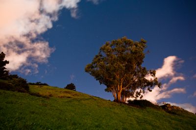
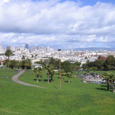
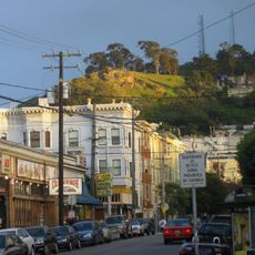
Billy Goat Hill features a network of trails leading through urban forest and grassland plant communities to a 500-foot elevation point.

The site originated as a quarry operated by Gray Brothers during the late 1800s and transformed into an official city park in 1975.

The park serves as a gathering space where residents participate in outdoor activities while appreciating views of the Bay Bridge and downtown.

Visitors can access the park from 30th Street or Beacon Street, with the Muni line 52 stopping near Walter Haas Park.

The park contains California saxifrage plants, which grow naturally in only two other locations throughout San Francisco.

Location: San Francisco

Location: San Francisco County

GPS coordinates: 37.74145,-122.43302

Latest update: March 23, 2025 18:14

The view
The view
QRCode
Sites and monuments of San Francisco: Golden Gate Bridge, Alcatraz and Victorian architecture

San Francisco brings together historical monuments and natural sites that reflect the city's unique history and geography. The Golden Gate Bridge, a 2,737-meter-long suspension bridge completed in 1937, is one of the region's most recognizable structures. Alcatraz Island, a former high-security federal prison operating from 1934 to 1963, is located in the bay and is visited by ferry. The Painted Ladies, seven Victorian houses built between 1892 and 1896, exemplify San Francisco’s characteristic residential architecture with their colorful facades facing Alamo Square Park. The city also includes Fisherman's Wharf, a historic port district developed from late 19th-century Italian fishing piers, and the Fillmore, a performance hall from the 1910s that contributed to the development of the West Coast music scene. Twin Peaks provide viewpoints at 928 feet (283 meters), while Lands End features rocky cliffs and hiking trails at the western tip of the peninsula. The Cable Cars, a mechanical transportation system operating since 1873, run on three lines through San Francisco's sloped streets.

Around this place
Show the full map
Sutro Tower
United States of America

Sutro Tower

2.3 km
Mission Dolores Park
United States of America

Mission Dolores Park

1.9 km
GLBT Historical Society
United States of America

GLBT Historical Society

2.2 km
Glen Canyon Park
United States of America

Glen Canyon Park

836 m
Boxer Stadium
United States of America

Boxer Stadium

2 km
Bernal Heights Summit
United States of America

Bernal Heights Summit

1.5 km
Alfred E. Clarke Mansion
United States of America

Alfred E. Clarke Mansion

2.1 km
Twin Peaks Tavern
United States of America

Twin Peaks Tavern

2.4 km
Alamo Drafthouse New Mission Cinema
United States of America

Alamo Drafthouse New Mission Cinema

2.1 km
Tank Hill
United States of America

Tank Hill

2.4 km
Kadist Art Foundation
United States of America

Kadist Art Foundation

2.5 km
Artists' Television Access
United States of America

Artists' Television Access

2 km
Second Church of Christ, Scientist
United States of America

Second Church of Christ, Scientist

2.1 km
Frank G. Edwards House
United States of America

Frank G. Edwards House

1.2 km
Mount Davidson cross
United States of America

Mount Davidson cross

1.9 km
Maxime Leforestier's blue house
United States of America

Maxime Leforestier's blue house

2.2 km
Bernal Heights Branch Library
United States of America

Bernal Heights Branch Library

1.5 km
Glen Park Branch Library
United States of America

Glen Park Branch Library

841 m
Eureka Valley - Harvey Milk Memorial Branch Library
United States of America

Eureka Valley - Harvey Milk Memorial Branch Library

2.5 km
Seward Street Slides
United States of America

Seward Street Slides

1.9 km
Excelsior Branch Library
United States of America

Excelsior Branch Library

1.6 km
Maison bleue, San Francisco
United States of America

Maison bleue, San Francisco

2.2 km
Castro Street Theatre
United States of America

Castro Street Theatre

2.4 km
Noe Valley - Sally Brunn Branch Library
United States of America

Noe Valley - Sally Brunn Branch Library

993 m
Mission Branch Library
United States of America

Mission Branch Library

1.6 km
La Grande Tank
United States of America

La Grande Tank

2.2 km
Geneva Office Building and Power House
United States of America

Geneva Office Building and Power House

2.6 km
Liberty Street Historic District
United States of America

Liberty Street Historic District

2 km
Show the full map

Reviews

Visited this place? Tap the stars to rate it and share your experience / photos with the community! Try now! You can cancel it anytime.

« Billy Goat Hill, San Francisco: Summit and park in Diamond Heights, San Francisco, United States » is provided by Around Us (aroundus.com). Images and texts are derived from Wikimedia project under a Creative Commons license. You are allowed to copy, distribute, and modify copies of this page, under the conditions set by the license, as long as this note is clearly visible.

Discover hidden gems everywhere you go!

From secret cafés to breathtaking viewpoints, skip the crowded tourist spots and find places that match your style. Our app makes it easy with voice search, smart filtering, route optimization, and insider tips from travelers worldwide. Download now for the complete mobile experience.

Around Us App Screenshot

A unique approach to discovering new places

Le Figaro

All the places worth exploring

France Info

A tailor-made excursion in just a few clicks

20 Minutes